Victorian Resources Online (archived)
DYS99 (Plot 3)
| Site: DYS99 (Plot 3) | Land Unit: Strathdownie |
 |
General Land Unit Description:
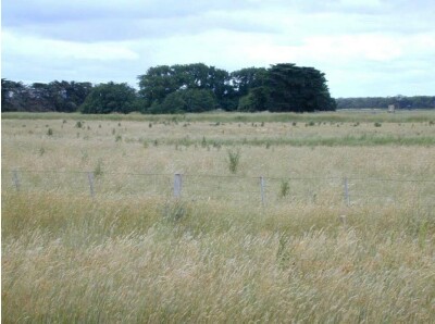
The soils are variable throughout this land unit due to varying depositional environments. A common soil type is a strong texture contrast soil (Chromosol) commonly with a bleached A2 horizon and a mottled subsoil (indicative of impeded internal drainage). The sandy topsoil can be very deep in some soils. Vertosols are also common on the plains and swales in between the dunes. Podosols occur on the flats as well as on the dunes and that may have been mapped as part of this land unit due to restrictions of scale. Many of the soils are poorly drained and exhibit signs of a perched watertable. This site has a 1.5 year old Eucalyptus globulus plantation on ex-agricultural land. The site is probably a heathland/bog. The trees in this plot have been severely affected by waterlogging. |
Site Description:
| Geology: Quaternary lacustrine | Landform pattern: Plain |
| Position in landscape: Flat | Internal drainage: Poorly drained |
Soil Profile Morphology
| A1 | 0-20 cm | Very dark greyish brown (10YR3/2) clay loam; weak angular blocky structure (10-20 mm); firm consistence when dry; few medium ferruginous nodules; many fine macropores; areal porosity 0.7%; common medium roots; clear and smooth transition to: | 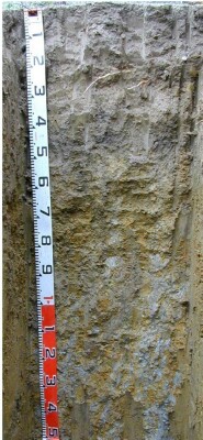 |
| Subsoil | |||
| B1 | 20-35 cm | Greyish brown (10YR5/2) with many medium faint yellowish brown (10YR5/4) and yellowish red (5YR4/6) mottles, light clay; weak angular blocky structure (20-50 mm); weak consistence when moderately moist; few medium ferruginous nodules; many fine macropores; areal porosity 0.5%; few very fine roots; clear and smooth transition to: | |
| B21 | 35-60 cm | Greyish brown (10YR5/2) with many medium faint yellowish brown (10YR5/4) and brownish yellow (10YR6/8) mottles, medium clay; moderate polyhedral structure (20-50 mm) parting to strong polyhedral structure (10-20 mm); weak consistence when moderately moist; few medium ferruginous nodules; many very fine macropores; areal porosity 0.3%; few very fine roots; diffuse and smooth transition to: | |
| B22 | 60-85 cm | Light yellowish brown (10YR6/4) with many medium faint brownish yellow (10YR6/8) and light grey (10YR7/1) mottles, medium clay; moderate polyhedral structure (20-50 mm) parting to moderate granular structure (2-5 mm); weak consistence when moderately moist; many very fine macropores; areal porosity 0.1%; few very fine roots; diffuse and smooth transition to: | |
| B23 | 85-150 cm | Light grey (10YR7/1) with many medium distinct brownish yellow (10YR6/8) and yellowish red (5YR5/8) mottles, medium heavy clay; strong lenticular structure (50-100 mm) (slickensides) parting to strong polyhedral structure (5-10 mm); weak consistence when moist; common very fine macropores; areal porosity 0.05%; few very fine roots (along cracks to 110 cm). | |
| 150-180 cm | Similar to layer above. | ||
| 180-310 cm | Grey heavy clay (slickensides) with light red mottles and iron concretions. | ||
| 310-390 cm | Grey heavy clay with yellow mottles and limestone segregations, no remnant roots observed. | ||
Notes: Sampled by: Ian Sargeant and Paul Feikema (13 December 2000)