Victorian Resources Online (archived)
Site SW18
Location: Glenormiston College (North Farm).
Australian Soil Classification: Vertic, Subnatric, Black SODOSOL
Northcote Factual Key: Dd2.22
Great Soil Group: solodic
Geology: Quaternary basalt (Qvn).
General Landscape Description: Level plain near the edge of some stony rises.
Site Description: Reserve at the edge of a grazing paddock.
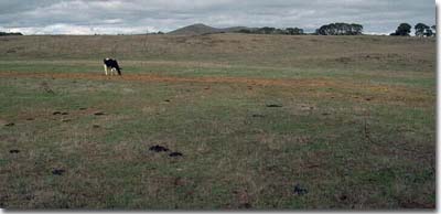 Site SW18 Landscape |
Soil Profile Morphology:
Surface Soil
| A1 | 0-20 cm | Very dark brown (10YR2/2); fine sandy clay loam; strong medium polyhedral structure; weak consistence dry; pH 5.1; gradual change to: | 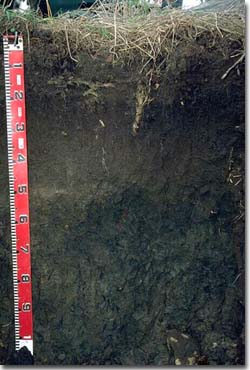 Site SW18 Profile |
| A2 | 20-50 cm | Dark brown (10YR3/3); fine sandy clay loam; weak consistence slightly moist; contains a few (2-5%) ferruginous nodules (2-6 mm in size) at the A/B horizon interface; pH 5.9; abrupt change to: | |
| Subsoil | |||
| B21 | 50-70 cm | Very dark brown (10YR2/2); medium heavy clay; moderate coarse prismatic structure; strong consistence slightly moist; contains a few (2-5%) iron nodules (2-6 mm in size); pH 7.2; gradual change to: | |
| B22 | 70-100 cm | Dark brown (10YR3/3) with a few (< 10%) yellowish brown (10YR5/6) mottles; medium heavy clay; moderate coarse prismatic, parting to moderate coarse blocky structure; very firm consistence slightly moist; contains a few (2-5%) manganese flecks and dark stains along root channels; slickensides are present at 1 metre depth; pH 7.6. | |
Key Profile Features:
- Strong texture contrast between surface (A) horizon (26% clay) and sodic subsoil (B21) horizon (53% clay).
- Vertic properties i.e. significant shrink-swell characteristics, in the subsoil.
pH | Salinity Rating | |||
Surface (A1 horizon) | strongly acid | low | - | none |
Subsoil (B21 horizon) | slightly alkaline | very low-low | sodic | strong 1 |
Deeper subsoil (at 1 m) | slightly alkaline | very low - low | strongly sodic | strong 1 |
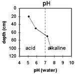 | The surface is strongly acid. The subsoil is slightly alkaline throughout. | 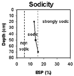 | The upper subsoil is sodic, becoming strongly sodic at 80 cm. |
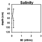 | The salinity rating is low to very low throughout the profile. | 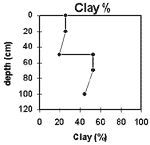 | The clay content increases abruptly at 50 cm by 27%. |
Horizon | Horizon Depth (cm) | pH (water) | pH (CaCl2) | EC 1:5 | Exchangeable Cations | |||
Ca | Mg | K | Na | |||||
meq/100g | ||||||||
A1 | 0-20 | 5.1 | 4.5 | 0.19 | 5.8 | 4.2 | 1.3 | 0.62 |
A2 | 20-50 | 5.9 | 4.7 | 0.07 | 2.7 | 2.9 | 1.1 | 0.5 |
B21 | 50-70 | 7.2 | 6.1 | 0.2 | 7.8 | 13 | 2.2 | 3.6 |
B22 | 70-100 | 7.6 | 6.8 | 0.19 | 5.4 | 9.5 | 1.5 | 3 |
Horizon | Horizon Depth (cm) | Wilting Point pF4.2 | Coarse Sand (0.2- 2.0 mm) | Fine Sand (0.02- 0.2 mm) | Silt (0.002- 0.02 mm) | Clay (<0.002 mm) |
A1 | 0-20 | 22 | 6 | 30 | 23 | 26 |
A2 | 20-50 | 10 | 10 | 39 | 27 | 20 |
B21 | 50-70 | 28 | 4 | 23 | 13 | 53 |
B22 | 70-100 | 22 | 6 | 30 | 17 | 44 |
Management Considerations:
Whole Profile
- Plant available water capacity (PAWC) is considered to be low (estimated at 70 mm). This is based on available laboratory data and assumes an effective rooting depth of 70 cm. Rooting depth will be restricted by the dense and strongly sodic subsoil. The availability of moisture to the plant depends to a large degree on soil structure and consistence. In dense and coarsely structured subsoils such as these, it is likely that there will be a large amount of unused ‘available’ moisture in the subsoil.
- The soil profile has a high level of exchangeable magnesium throughout. Values of the ratio of exchangeable magnesium to CEC of greater than 20% may induce potassium deficiency in some soils (Baker and Eldershaw, 1993).
- The surface horizon (A1) is strongly acid. This indicates that aluminium and manganese toxicity may occur. The level of exchangeable aluminium measured at this site (53 ug/kg) may restrict the growth of highly aluminium sensitive species e.g. lucerne. However, a pH/aluminium test is best performed from samples taken across the paddock and bulked together. There may be benefits in applying lime on this soil. However, other factors need to be considered before lime is recommended e.g. pasture species grown, method of application, local trial responses, soil surface structure and likely cost benefit.
- Deficiencies of molybdenum, phosphorus and potassium can occur in strongly acid soil. Increasing pH by lime application should enable phosphorus (from superphosphate) and molybdenum to become more available. If lime is required, and pH is increased, then the availability of major nutrients should improve.
- Manganese toxicity can also occur in strongly acid soils, particularly under waterlogged conditions.
- The inherent fertility of the surface soil is moderate based on the sum of the exchangeable cations (Ca, Mg, K).
- The coarsely structured subsoil is sodic and strongly dispersive. The deeper subsoil becomes strongly sodic at 80 cm depth. These subsoil conditions will result in restricted root and water movement down the profile.
- The subsoil is mottled, indicating that drainage is imperfect within the subsoil.
- The subsoil displays vertic properties i.e. slickensides which indicates that significant shrinking and swelling occurs with wetting and drying cycles. This may disturb the roots of some plant species. The shrinking and swelling also has engineering implications e.g. disturbance to building foundations and fence lines.
References:
Baker, D.E. and Eldershaw, V.J. (1993). Interpreting Soil Analysis for Agricultural Land Use in Queensland. Project Report Series. Queensland, Department of Primary Industries.