Victorian Resources Online (archived)
Site SW19
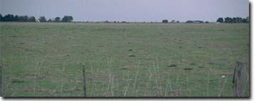
Location: Glenormiston College.
Australian Soil Classification: Melacic, Eutrophic, Brown CHROMOSOL
Northcote Factual Key: Db2.12
Great Soil Group: podzolic
Geology: Quaternary volcanic tuff deposits (Qvs) derived from Mt. Noorat.
General Landscape Description: Level Plain.
Site Description: Paddock reserve associated with a non-irrigated dairy paddock.
 Site SW19 Landscape |
Soil Profile Morphology:
Surface Soil
| A11 | 0-30 cm | Very dark brown (10YR2/2); fine sandy clay loam; strong polyhedral, parting to fine polyhedral structure; slight compaction evident; weak consistence dry; pH 4.9; abrupt change to: | 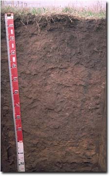 Site SW19 Profile |
| A12 | 30-35 cm | Very dark brown (10YR2/2); fine sandy clay loam; very firm consistence dry; contains many (40%) manganese nodules (2-6 mm in size) as well as an ironstone accumulation and many dark root channels; pH 5.6; abrupt change to: | |
| Subsoil | |||
B21 | 35-70 cm | Brown (7.5YR4/4); medium heavy clay; strong polyhedral, parting to fine polyhedral structure (shiny-faced peds); very firm consistence moist; contains few (5%) manganese nodules (2-5 mm in size) as well as worm casts; pH 6.4; clear change to: | |
| B22 | 70-100 cm | Brown (7.5YR4/4) with slight strong brown (7.5YR5/6) mottles; medium clay; moderate coarse polyhedral, parting to strong fine polyhedral structure; very firm consistence moist; contains few (2%) manganese nodules (2-5 mm in size) as well as few (10%) manganese stains; pH 7.0; abrupt change to: | |
| C1 | 100-120 cm | Mainly weathered yellow brown volcanic tuff: | |
C2 | 120+ cm | Dark brown (7.5YR3/3); volcanic tuff; contains some olivine. |
Key Profile Features:
- Strong texture contrast between the sub-surface (A12) horizon (29% clay) and the sodic subsoil (B21) horizon (65% clay).
pH | Salinity Rating | |||
Surface (A1 horizon) | very strongly acid | low | non-sodic | none |
Subsoil (B21 horizon) | slightly acid | very low | non-sodic | none |
Deeper subsoil (at 1m) | neutral | very low | non-sodic | none |
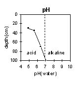 | 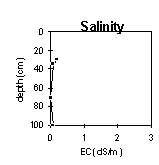 | 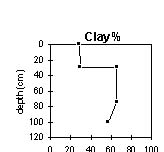 |
The surface is very strongly acid. The subsoil is slightly acid, becoming neutral at 80 cm depth. | The salinity rating is low to very low throughout the profile. | The clay content increases abruptly at the A/B horizon boundary. |
Horizon | Horizon Depth (cm) | pH (water) | pH (CaCl2) | EC 1:5 | Exchangeable Cations | |||
Ca | Mg | K | Na | |||||
meq/100g | ||||||||
A12 | 30-35 | 5.6 | 4.7 | 0.06 | 7.1 | 2.6 | 0.46 | 0.33 |
B21 | 35-70 | 6.4 | 5.4 | <0.05 | 14 | 8.8 | 0.81 | 0.52 |
B22 | 70-100 | 7 | 6.2 | 0.08 | 13 | 15 | 0.66 | 0.74 |
Horizon | Horizon Depth (cm) | Wilting Point pF4.2 | Coarse Sand (0.2- 2.0 mm) | Fine Sand (0.02- 0.2 mm) | Silt (0.002- 0.02 mm) | Clay (<0.002 mm) |
A12 | 30-35 | 16.4 | 24 | 23 | 18 | 29 |
B21 | 35-70 | 28.9 | 9 | 12 | 5 | 65 |
B22 | 70-100 | 29.6 | 5 | 18 | 14 | 57 |
Management Considerations:
Whole Profile
- Plant available water capacity (PAWC) is considered to be medium (estimated at 120 mm). This is based on available laboratory data and assumes an effective rooting depth of 100 cm. Effective plant available water in the subsoil will be higher for this profile compared to sites SW17 and SW18. The subsoil at site SW19 and SW16 is non-sodic and has better structure.
- The inherent fertility of the surface soil is low-moderate, based on the sum of the exchangeable cations (Ca, Mg, K).
- The surface (A1) horizon is very strongly acid. This indicates that aluminium and manganese toxicity may occur. The level of exchangeable aluminium measured at this site is high (140 mg/kg) and may restrict the growth of aluminium sensitive species e.g. lucerne. However, a pH/aluminium test is best performed from samples taken across the paddock and bulked together. There may be benefits in applying lime on this soil. Other factors also need to be considered before lime is recommended e.g. pasture species grown, method of application, local trial responses, soil surface structure and likely cost benefit.
- Manganese toxicity can also occur in strongly acid soils, particularly under waterlogged conditions.
- Deficiencies of molybdenum, phosphorus and potassium can occur in strongly acid soil. Increasing pH by lime application should enable phosphorus (from superphosphate) and molybdenum to become more available. If lime is required, and pH is increased, then the availability of major nutrients should improve.
- The subsoil has a high inherent fertility, based on the sum of the exchangeable cations (Ca, Mg, K).
- The subsoil is non-sodic and non-dispersive. It is also well structured, parting down to fine polyhedral shaped peds. Water movement should not be significantly restricted as a result and subsoil drainage will be better than for sites SW17 and SW18. The increase in clay content at the A/B horizon interface may result in some restricted water movement as compared to sites SW16 and SW20 where there is a more gradual texture change.