Victorian Resources Online (archived)
MM367
| Site: MM367 | Land Unit: Richie Hill |
| Aust. Soil Class.: Mottled-Sodic, ?, Brown CHROMOSOL (confidence level 4) | |
| General Land Unit Description: This unit consists the undulating slopes of Richie Hill north of Streatham. The soils are typically Brown Chromosols on the steeper slopes, and Brown Sodosols on the gentler colluvial slopes (Richie Hill Slopes land unit). There are minor occurrences of Black Chromosols or Dermosols. |
Site Description:
| Geology: Quaternary basalt | Landform pattern: Undulating rises |
| Position in landscape: Mid slope | Internal drainage: Imperfectly drained |
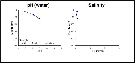
| A1 | 0-20 cm | Dark reddish brown (5YR3/4) clay loam, moderate blocky structure (10-20mm), ferromanganiferous nodules are common, pH 4.9. Clear transition to: |
| A2 | 20-25 cm | Reddish brown (5YR4/4) clay loam, ferromanganiferous nodules are common. Sharp transition to: |
| Subsoil | ||
| B21 | 25-40 cm | Red (2.5YR4/6) light clay, strong blocky structure (5-10 mm), pH 6.1. Gradual transition to: |
| B23 | 60+ cm | Brown (7.5YR4/4) medium clay, red mottles (2.5YR4/6), strong blocky structure (5-10 mm), pH 6.9. |
Key profile features:
- Strongly acidic topsoil
- Strong texture contrast between topsoil and subsoil
- Ferromanganiferious nodules are common in topsoil
- Mottled subsoil
- Topsoil dispersive when worked when wet
- Top of subsoil dispersive when worked when wet
- Deeper subsoil sodic