Victorian Resources Online (archived)
MM371
| Site: MM371 | Land Unit: Tatyoon Basalt |
| Aust. Soil Class.: Mottled-Sodic, ?, Brown CHROMOSOL (confidence level 3) | |
| General Land Unit Description: This land unit occupies a large area of basalt east of Willaura. The major soil types on the crests and slopes tends to be Brown Chromosols which are often sodic at depth, or Brown Sodosols. On the lower slopes or depressions, Grey Sodosols tend to be the dominant soil type. The topsoil is often highly acidic. There are isolated occurrences of red soils on the better drained areas. |
Site Description:
| Geology: Quaternary basalt | Landform pattern: Gently undulating rises |
| Position in landscape: Mid slope | Internal drainage: Moderately well drained |
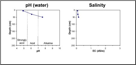
| A1 | 0-10 cm | Dark brown (10YR3/3) clay loam, ferromanganiferous nodules are common, pH 4.1 (water). Sharp transition to: |
| Subsoil | ||
| B21 | 10-50 cm | Yellowish brown (10YR5/4) medium clay, red mottles(2.5YR4/6), strong blocky structure (5-10 mm), pH 6.9. Gradual transition to: |
| B22 | 50+ cm | Reddish brown (2.5Y5/4) heavy clay, red mottles (2.5YR4/6), strong blocky structure (20-50 mm), ferromanganiferous nodules are common, pH 7.6. |
Key profile features:
- Strong texture contrast between topsoil and subsoil
- Strongly acidic topsoil
- Ferromanganiferious are common
- Deeper subsoil sodic