Victorian Resources Online (archived)
MM498
| Site: MM498 | Land Unit: Glenormiston–Terang Basalt Plains |
| Aust. Soil Class.: Ferric, Mottled-Subnatric, Black SODOSOL (confidence level 3) | |
| General Land Unit Description: This land unit consists of the gently undulating basalt plains in the Glenormiston–Terang area. The dominant soils are Ferric Black Sodosols, commonly with a bleached A2 horizon and or a mottled subsoil. There are minor occurrences of Black and Brown Chromosols, commonly with a ferric horizon above the clay. |
Site Description:
| Geology: Quaternary basalt | Landform pattern: Gently undulating plains |
| Position in landscape: Mid slope | Internal drainage: Imperfectly drained |
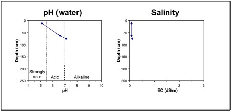
| A1 | 0-15 cm | Very dark brown (10YR2/2), clay loam, hard setting surface condition, apedal, firm consistence when dry, ferromanganiferous nodules are common, pH 5.1. Clear transition to: |
| A2 | 20-50 cm | Sporadically bleached when dry (10YR7/2), clay loam, ferromanganiferous nodules are abundant. Sharp transition to: |
| Subsoil | ||
| B21 | 50-75 cm | Very dark greyish brown (10YR3/2) heavy clay, dark yellowish brown mottles, strong blocky structure (20-50 mm), pH 6.6. Gradual transition to: |
| B22 | 75+ cm | Grey (2.5Y4/2), heavy clay, yellowish brown mottles, strong blocky structure (20-50 mm), pH 7.1. |
Key profile features:
- Strongly acidic topsoil
- Bleached A2 horizon
- Ferromanganiferious nodules are abundant in A2 horizon
- Strong texture contrast between topsoil and subsoil
- Mottled subsoil
- Topsoil dispersive when worked when wet
- Subsoil dispersive when worked wen wet