Victorian Resources Online (archived)
MM581
| Site: MM581 | Land Unit: Glenthompson Granites |
| Aust. Soil Class.: Ferric, Mottled-Subnatric, Brown SODOSOL (confidence level 3) | |
| General Land Unit Description: This land unit comprises a small area of Cambrian granites south of Glenthompson. The soils tend to have a strong texture contrast with a sodic subsoil. There are many ferromangaiferous nodules above the clay, which is common to many soils in the study area. The mottled subsoil and the bleached A2 horizon indicate that the soil is imperfectly drained. This feature, together with the ferric horizon, would be the major restriction for land use. |
Site Description:
| Geology: Cambrian granite | Landform pattern: Undulating rises |
| Position in landscape: Upper slope | Internal drainage: Moderately well drained |
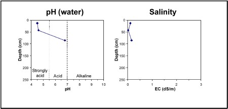
| A1 | 0-25 cm | Very dark grey (10YR3/1) loamy sand, consistence very weak, pH 5. Gradual transition to: |
| A2 | 25-60 cm | Yellowish brown (10YR5/4) sand, conspicuously bleached (10YR7/2) when dry, single grain structure, pH 5. Clear transition to: |
| A22 | 60-80 cm | Brown (10YR4/3) loamy sand, many medium ferromanganiferous nodules (2-6 mm). Sharp transition to: |
| A3 | 80-85 cm | Dark yellowish brown (10YR4/4) sandy loam, yellowish red (5YR4/6) mottles. Sharp transition to: |
| Subsoil | ||
| B21 | 85+ cm | Yellowish brown (10YR5/6) medium clay, yellowish red (5YR4/6) mottles, weak blocky structure (20-50 mm), pH 7. |
Key profile features:
- Strongly acidic topsoil
- Deep sandy topsoil
- Bleached A2 horizon
- Strong texture contrast between topsoil and subsoil
- Mottled subsoil
- Sodic subsoil
- Many ferromanganiferous nodules in A22 horizon