Victorian Resources Online (archived)
MM625
| Site: MM625 | Land Unit: Woorndoo Basalt |
| Aust. Soil Class.: Ferric, ?, Brown CHROMOSOL (confidence level 4) | |
| General Land Unit Description: This unit occurs on the level to gently undulating basalt plains in the Woorndoo area. The soils consist of Ferric Brown Chromosols in association with Black Chromosols and Black Sodosols. The Black Chromosols and Sodosols typically occur on areas that experience gilgai microrelief. |
Site Description:
| Geology: Quaternary basalt | Landform pattern: Level to gently undulating plain |
| Position in landscape: Flat | Internal drainage: Imperfectly drained |
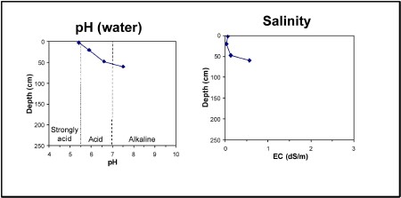
| A1 | 0-5 cm | Dark greyish brown (10YR4/2) clay loam, ferromanganiferous nodules are common, pH 5.4. Clear transition to: |
| A2 | 5-35 cm | Sporadically bleached clay loam, ferromanganiferous are abundant, pH 5.9. Sharp transition to: |
| Subsoil | ||
| B21 | 35-60 cm | Yellowish brown (10YR5/6) medium clay, red mottles (2.5YR4/6), firm consistence when moist, ferromanganiferous nodules are abundant, pH 6.6. Gradual transition to: |
| B22 | 60+ cm | Light yellowish brown (2.5Y6/4) medium clay, firm consistence when moist, many ferromanganiferous nodules, pH 7.5. |
Key profile features:
- Strongly acidic topsoil
- Ferromanganiferious are abundant
- Mottled subsoil