Victorian Resources Online (archived)
MM667
| Site: MM667 | Land Unit: Basalt Alluvial |
| Aust. Soil Class.: ?, Mottled-Subnatric, Brown SODOSOL (confidence level 3) | |
| General Land Unit Description: This land unit consists of the smaller swamps and depressions which occur on the basalt plains. Grey Vertosols tend to dominate the smaller swamps and depressions on the plains. Black Vertosols are commonly found in the swamps and depressions associated with the stony rise landscapes and the larger alluvial plains. Both soil types are typically sodic at depth and imperfectly drained. There are minor occurrences of Sodosols, similar to this site. In some areas of the basalt plain, this land unit would have been incorporated into the basalt land units. |
Site Description:
| Geology: Quaternary alluvium | Landform pattern: Gently undulating plain |
| Position in landscape: Drainage depression | Internal drainage: Imperfectly drained |
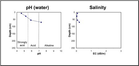
| A11 | 0-15 cm | Very dark greyish brown (10YR3/2) clay loam, hard-setting surface, pH 4.6, clear transition to: |
| A12 | 15-40 cm | Greyish brown (10YR5/2) silty clay loam, conspicuously bleached (10YR7/1) when dry, pH 5.2, sharp transition to: |
| Subsoil | ||
| B21 | 40-70 cm | Yellowish brown (10YR5/4) medium clay, brownish yellow mottles, pH 5.9, clear transition to: |
| B22 | 70+ cm | Brown (10YR5/3) heavy clay, brownish yellow mottles, pH 7.3. |
Key profile features:
- Strongly acidic topsoil
- Strong texture contrasts between topsoil and subsoil
- Bleached A2 horizon
- Mottled subsoil
- Sodic topsoil
- Topsoil dispersive when dry
- Sodic subsoil
- Subsoil dispersive when dry