Victorian Resources Online (archived)
MM726
| Site: MM726 | Land Unit: Buckley Swamp Peats |
| Aust. Soil Class.: Terric, Acidic, Sapric ORGANOSOL (confidence level 4) | |
| General Land Unit Description: Buckley Swamp consists of a valley infilled by an earlier lava flow, with the subsequent blockage of the drainage line resulting in peat accumulation. The area has been drained and burnt at various times in the past, resulting in some decomposition and loss of peat. The dominant soils of the plain are Organosols with massive or well-structured surfaces. The soils of the backplain are commonly Hydrosols with well structured surfaces and peaty horizons. There are also minor occurrences of Vertosols. |
Site Description:
| Geology: Quaternary basalt overlain by alluvium | Landform pattern: Flood plain |
| Position in landscape: Drainage depression | Internal drainage: Imperfectly drained |
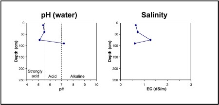
| A11 | 0-20 cm, | Loam (possibly peat), soft surface, very weak consistence when moist, pH 5.4. Gradual transition to: |
| A12 | 20-60 cm | Loam (possibly peat), very weak consistence when moist, pH 5.5. Sharp transition to: |
| Subsoil | ||
| D1 | 60-90 cm | Very dark brown (10YR2/2) light clay, red mottles, blocky structure, firm consistence when moist, pH 5.1. Clear transition to: |
| D2 | 90+ cm | Very dark grey (10YR3/1) medium clay, red mottles, very firm consistence when moist, pH(water) 7.2. |
Key profile features:
- Strongly acidic topsoil
- Strongly acidic subsoil
- Strong texture contrast between topsoil and subsoil
- Mottled subsoil