Victorian Resources Online (archived)
MM752
| Site: MM752 | Land Unit: Hawkesdale West Basalt |
| Aust. Soil Class.: Ferric, ?, Brown CHROMOSOL (confidence level 3) | |
| General Land Unit Description: The gently undulating rises and undulating plains between Macarthur and Hawkesdale consist of Ferric Brown Chromosols on the crests and rises and Bleached-Ferric Chromosols on the lower slopes. There are minor occurrences on upper slope’s and crests of Chromosols with shallow soils. Relatively poorer drained mottled brown or yellow Chromosols may occur on flats and Sodosols are minor soils of the drainage lines between rises. Areas of gilgai microrelief may occur on the flats where the soils are often black Chromosols. A few surface stones usually occur on rises with gilgai microrelief. |
Site Description:
| Geology: Quaternary basalt | Landform pattern: Level to gently undulating plain |
| Position in landscape: Upper slope | Internal drainage: Imperfectly drained |
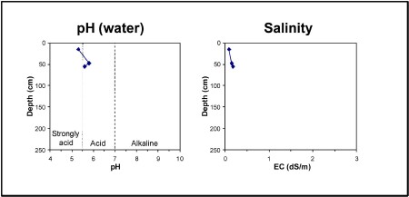
| A11 | 0-30 cm | Very dark greyish brown (10YR3/2) clay loam, pH 5.3. Clear transition to: |
| A12 | 30-40 cm | Very dark greyish brown (10YR3/2) clay loam, ferromanganiferous nodules are abundant. Sharp transition to: |
| Subsoil | ||
| B21 | 40-55 cm | Yellowish brown (10YR5/6) medium clay, red mottles (2.5YR4/6), basalt fragments are common (200-600 mm), strong blocky structure (5-10 mm), pH 5.8 . |
| B22 | 55+ cm | Yellowish brown (10YR5/6) medium clay, red mottles (2.5YR4/6), basalt fragments are common (200-600 mm), strong blocky structure (5-10 mm), pH 5.6 . |
Key profile features:
- Acidic topsoil
- Ferromanganiferious nodules are abundant above the clay
- Topsoil dispersive when worked when wet
- Subsoil dispersive when worked when wet