Victorian Resources Online (archived)
MM754
| Site: MM754 | Land Unit: Warrabkook Basalts |
| Aust. Soil Class.: Ferric, Mottled-Subnatric, Brown SODOSOL (confidence level 3) | |
| General Land Unit Description: This land unit consists of gently undulating basalt plains in the Macarthur area. In some drainage lines, the basalt has been dissected sufficiently to expose the underlying sediments. The soils on the basalt plains are commonly Brown Kurosols or Chormosols, intermixed with Sodosols, particularly on the lower slopes and drainage depressions. |
Site Description:
| Geology: Quaternary basalt | Landform pattern: Undulating plain |
| Position in landscape: Mid to lower slope | Internal drainage: Imperfectly drained |
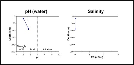
| A11 | 0-35 cm | Very dark greyish brown (10YR3/1) loamy sand, apedal structure (single grain), pH 5.0. Gradational transition to: |
| A12 | 35-70 cm | Brown (10YR4/3) sandy loam. Gradational transition to: |
| A2 | 70-90 cm | Pale brown (10YR6/3) sandy loam, conspicuously bleached (10YR7/2) when dry, ferromanganiferous nodules are abundant. Sharp transition to: |
| Subsoil | ||
| B21 | 90+ cm | Yellowish brown (10YR5/4), heavy clay, yellowish brown mottles, pH 5.7. |
Key profile features:
- Acidic topsoil
- Ferromanganiferious nodules are abundant in A2 horizon
- Sodic subsoil
- Strong texture contrast between topsoil and subsoil
- Bleached A2 horizn
- Mottled subsoil