Victorian Resources Online (archived)
SW16
Location: Glenormiston College.
Australian Soil Classification: Melanic-Sodic, Eutrophic, Black DERMOSOL
Northcote Factual Key: Gn3.42
General Landscape Description: Level Plain.
Site Description: Irrigated paddock.
Geology: Quaternary volcanic tuff and scoriaceous deposits (Qvs) derived from Mt. Noorat.
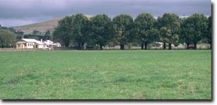 SW16 Landscape |
Soil Profile Morphology
Surface Soil
| A1 | 0-15 cm | Very dark brown (10YR2/2); clay loam; strong medium polyhedral, parting to strong fine polyhedral structure; weak consistence moist; contains few (5%) ferromanganiferous nodules (2-5 mm in size); some compaction present; pH 7.8; gradual change to: | 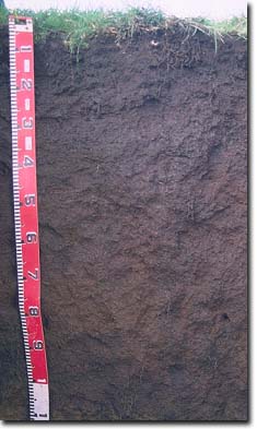 SW16 Profile |
| Subsoil | |||
| B21 | 15-25 cm | Very dark brown (10YR2/2); light clay; strong medium polyhedral, parting to strong fine polyhedral structure; weak consistence moist; contains few (2-5%) ferromanganiferous nodules (2-5 mm in size); pH 7.8; clear change to: | |
| B22 | 25-45 cm | Dark brown (7.5YR3/2); medium heavy clay; strong medium blocky, parting to strong fine blocky structure; shiny-faced peds; firm consistence moist; contains few (2-5%) ferromanganiferous nodules (2-5 mm in size); pH 7.8; clear change to: | |
| B23 | 45-75 cm | Dark reddish brown (5YR3/3) with many reddish brown (5YR4/4) mottles; medium heavy clay; moderate coarse polyhedral structure; weak consistence moist; contains few (5-10%) ferromanganiferous nodules (2-6 mm in size); pH 7.9; gradual change to: | |
| B24 | 75-105 cm | Yellowish red (5YR5/6) with some brown (7.5YR4/2) mottles; fine sandy clay loam (gritty); moderate coarse polyhedral structure; weak consistence moist; contains few (5%) ferromanganiferous nodules (2-10 mm in size); pH 8.3; 70-90 cm depth has a discontinuous scoria layer: | |
| C | 105+ cm | Volcanic tuff. | |
Key Profile Features:
- Minimal texture contrast between surface (A) horizon and subsoil (B21) horizon.
- Well structured soil profile throughout.
pH | Salinity Rating | |||
Surface (A1 horizon) | Slightly Alkaline | Low | Non-Sodic | None 1 |
Subsoil (B21 horizon) | Slightly Alkaline | Very Low | Non-Sodic | None 2 |
Deeper subsoil (at 80 cm) | Moderately Alkaline | Low | sodic | None |
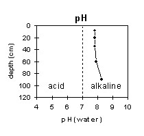 | 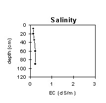 | 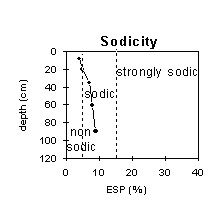 | 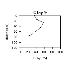 |
The surface soil is slightly alkaline, becoming moderately alkaline at 80 cm. | The salinity rating is low to very low throughout | The surface soil is non-sodic. The sub-soil becomes sodic at about 30 cm. | The clay content increases gradually with depth in the upper profile and then decreases in the lower profile. |
Horizon | Horizon Depth (cm) | pH (water) | pH (CaCl2) | EC 1:5 | Exchangeable Cations | |||
Ca | Mg | K | Na | |||||
meq/100g | ||||||||
A1 | 0-15 | 7.8 | 6.9 | 0.15 | 22 | 19 | 1.9 | 1.8 |
B21 | 15-25 | 7.8 | 6.9 | 0.15 | 19 | 21 | 1.3 | 2 |
B22 | 25-45 | 7.8 | 6.8 | 0.2 | 16 | 23 | 0.64 | 2.9 |
B23 | 45-75 | 7.9 | 7.1 | 0.24 | 14 | 24 | 0.47 | 3.2 |
B24 | 75-105 | 8.3 | 7.5 | 0.23 | 19 | 22 | 0.33 | 3.7 |
Horizon | Horizon Depth (cm) | Wilting Point pF4.2 | Coarse Sand (0.2- 2.0 mm) | Fine Sand (0.02- 0.2 mm) | Silt (0.002- 0.02 mm) | Clay (<0.002 mm) |
A1 | 0-15 | 33 | 9 | 16 | 21 | 37 |
B21 | 15-25 | 30 | 8 | 16 | 20 | 42 |
B22 | 25-45 | 37 | 6 | 13 | 12 | 58 |
B23 | 45-75 | 36 | 8 | 13 | 13 | 51 |
B24 | 75-105 | 30 | 16 | 23 | 25 | 23 |
Management Considerations:
Whole Profile
- Plant available water capacity (PAWC) is considered to be medium (estimated at 110 mm) for this profile. Effective rooting depth is estimated to be 100 cm. Most roots evident in the soil profile occur in the upper 70 cm.
- The soil profile has a relatively high level of exchangeable calcium. This promotes flocculation of clays and results in the soil being well structured (parting down strongly into fine sized polyhedral shaped peds) and having a weak consistence when moist. These conditions are very favourable for root and water movement down the profile. The high organic matter levels in the upper soil profile also contribute to favourable soil structure.
- The soil profile also has a high free iron oxide content (5% in B21 horizon) which also contributes to the well-developed structure. However, the free iron oxide, will tend to ‘fix’ phosphorus which makes it less available to plants. Regular phosphorus application will assist in overcoming such a deficiency. Zinc and copper can also be ‘fixed’ by high iron oxide contents.
- The soil profile has a very high inherent fertility based on the sum of the exchangeable cations (Ca, Mg, K).
- The soil profile has a high level of exchangeable magnesium throughout. Values of the ratio of exchangeable Magnesium to CEC of greater than 20% may induce potassium deficiency in some soils (Baker and Eldershaw, 1993).
- The relatively higher pH levels in the upper subsoil may be due to the irrigation water having a high calcium level.
- The surface soil has a very high inherent fertility based on the sum of the exchangeable cations (Ca, Mg, K) and high total nitrogen levels, which is associated with high organic matter levels.
- The surface soil is well structured (parting strongly to fine polyhedral shaped peds) and friable when moist. This will create ideal seedbed conditions. The high organic matter content will also assist in maintaining a high degree of water-stable aggregation. Infiltration rates will be high as a result.
- The high wilting point value (33%) indicates that plants will be unable to utilise light rains when the soil is relatively dry. If the soil dries out, then small amounts of rain may not be sufficient to wet the soil above permanent wilting point. Moisture stress is likely to occur during dry periods. The high wilting point indicates that water is ‘held tightly’ by the soil which decreases it’s availability to plants as the water content approaches this point.
- Due to the reasonably high clay content in the surface horizon, excessive cultivation or trafficking when the soil is moist may result in soil compaction developing. Cultivation or heavy trafficking should be avoided when the soil is wetter than the plastic limit. Some evidence of compaction was evident at this site.
- The upper subsoil is non-sodic. However, it does disperse strongly after remoulding. This indicates that structural deterioration can occur if this horizon is disturbed by cultivation whilst in a moist condition.
- The subsoil is also very well structured (parting to fine polyhedral shaped peds) which will be advantageous for root and water movement. Internal drainage will be good.
Profile Described By: Mark Imhof and David Rees (May 1997).
References:
Baker, D.E. and Eldershaw, V.J. (1993). Interpreting Soil Analysis for Agricultural Land Use in Queensland. Project Report Series. Queensland, Department of Primary Industries.