Victorian Resources Online (archived)
SW2
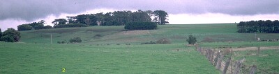
Location: Grassmere
Australian Soil Classification: Humose, Hypocalcic, Black CHROMOSOL
Northcote Factual Key: Dd1.13
Great Soil Group:rendzina
General Landscape Description: Lower terrace of Merri Creek.
Land Unit: Port Campbell Limestone (Tmc).
Geology: Quaternary alluvial material and volcanic ash deposits overlying Tertiary period
 SW2 Landscape |
Soil Profile Morphology:
Surface Soil
| A11 | 0-15 cm | Black (10YR2/1); clay loam; strong medium polyhedral, parting to strong fine polyhedral structure; weak consistence moist; pH 7.6; gradual change to: | 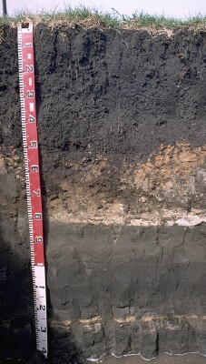 SW2 Profile |
| A12 | 15-25 cm | Black (10YR2/1) clay loam; strong medium polyhedral, parting to strong fine polyhedral structure; weak consistence moist; pH 7.8; clear to gradual change to: | |
| Subsoil | |||
| B21 | 25-45 cm | Black (10YR2/1) light medium clay; strong medium polyhedral, parting to strong fine polyhedral structure (smooth faced peds); weak consistence moist; pH 8.0; gradual change to: | |
| B22 | 45-60 cm | Dark brown (7.5YR3/2) light clay; moderate medium blocky, parting to strong fine subangular blocky structure; weak consistence moist; pH 8.1 ; abrupt change to: | |
The underlying horizons are layered tuff, volcanic ash and alluvial deposits of varying thickness. | |||
| D1 | 60-80 cm | Greyish brown (10YR5/2) clayey marl; weakly structured; very weak consistence moist; contains a few (10%) carbonate nodules (5 -15 mm size); pH 8.6; clear change to: | |
| D2 | 80-90 cm | Dark greyish brown (10YR4/2) fine sandy marl, structureless; very firm consistence moderately moist; abrupt change to: | |
| D3 | 90-100 cm | Very dark greyish brown (2.5Y3/2) fine sandy loam; structureless; pH 8.8; sharp change to: | |
| D4 | 100-102 cm | Carbonate layer | |
| D5 | 102-120 cm | Very dark grey (10YR3/1) fine sandy marl; very firm consistence, moderately moist; variably compacted; distinctly layered. | |
Key Profile Features:
- Texture contrast between surface (A) horizons and upper subsoil (B21) horizon.
- High organic matter content in surface horizons.
- Presence of old lake bed deposits from 60 cm depth.
Soil Profile Characteristics:
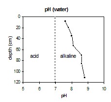
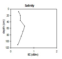
- | pH | Salinity | ||
Surface Soil (A11 horizon) | Slightly Alkaline | Medium | Non-Sodic | - |
Subsoil (25-45 cm) | Moderately Alkaline | Medium | Non-Sodic | None |
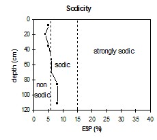
Deeper Subsoil (102-120 cm) | Strongly Alkaline | High | Sodic | None |
 |  |  | 
|
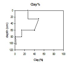
| The surface horizons are slightly alkaline. The subsoil is moderately alkaline. The marly D horizons are strongly alkaline. | The salinity rating is low-moderate for the upper 45 cm of the profile. The rating then becomes medium-high in the deeper subsoil before decreasing in the marl D horizons. | The surface horizons and upper subsoil are non-sodic. The deeper subsoil and marl D horizons are marginally sodic. | The clay percentage increases significantly at the A/B horizon interface |
| Horizon | Horizon Depth (cm) | pH (water) | pH (CaCl2) | EC dS/m | Organic Carbon % | Total Nitrogen % | Exchangeable Cations | Coarse Sand (0.2-2.0 mm) % | Fine Sand (0.02-0.2 mm) % | Silt (0.002-0.02 mm) % | Clay (<0.002 mm) % | Wilting Point % w/w | |||
| Ca | Mg | K | Na | ||||||||||||
| meq/100g | |||||||||||||||
| A11 | 0-15 | 7.6 | 7.0 | 0.35 | 6.0 | 0.62 | 42 | 13 | 0.72 | 2.9 | 8 | 20 | 22 | 27 | 39.7 |
| A12 | 15-25 | 7.8 | 7.3 | 0.43 | 4.5 | 47 | 12 | 0.58 | 2.2 | 8 | 21 | 24 | 26 | 32.6 | |
| B21 | 25-45 | 8.0 | 7.4 | 0.42 | 1.5 | 49 | 18 | 1.03 | 3.2 | 7 | 15 | 14 | 49 | 46.2 | |
| B22 | 45-60 | 8.1 | 7.6 | 0.61 | 48 | 25 | 0.99 | 4.8 | 6 | 16 | 22 | 41 | 47.6 | ||
| D1 | 60-80 | 8.6 | 7.9 | 0.53 | 49 | 24 | 0.45 | 4.6 | 3 | 18 | 12 | 14 | 27.6 | ||
| D2 | 80-90 | 8.6 | 8.0 | 0.46 | 43 | 18 | 0.63 | 5.3 | 15 | 39 | 7 | 2 | 21.8 | ||
| D5 | 102-120 | 8.8 | 8.1 | 0.31 | 29 | 8.3 | 0.79 | 3.2 | 17 | 46 | 2 | 3 | 12.6 | ||