Victorian Resources Online (archived)
SW41
Location: Elingamite
Australian Soil Classification: Bleached-Vertic (& Ferric), Eutrophic, Brown CHROMOSOL
General Landscape Description: Level plain (between basalt barriers).
Site Description: Grazing paddock (dairy).
Mapping Unit: Unit 2 (Maher and Martin, 1987).
Geology: Quaternary - Newer volcanics (basalt).
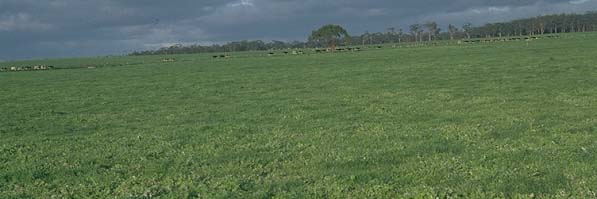 Site SW41 Landscape |
Soil Profile Morphology:
Surface Soil
| A1 | 0-10 cm | Very dark greyish brown (10YR3/2); very fine sandy clay loam; moderate medium blocky structure; weak consistence moist; pH 5.7; clear change to: |
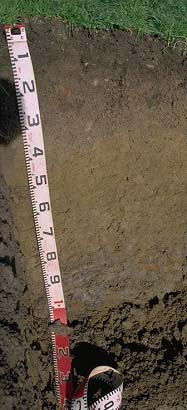 Site SW41 profile |
| A21 | 10-20 cm | Yellowish brown (10YR5/8); fine sandy clay loam; firm consistence, dry; contains a few (5%) basalt fragments; pH 5.5; clear change to: | |
| A22 | 20-40 cm | Brown (10YR5/3), conspicuously bleached; fine sandy clay loam; firm consistence, dry; contains very many (70%) ferruginous nodules (2-10 mm in size); pH 6.0; sharp and wavy change to: | |
| Subsoil | |||
| B21 | 40-60 cm | Yellowish brown (10YR5/4) with a few bright yellowish brown (10YR5/8) mottles; medium clay; strong medium blocky, parting to strong fine polyhedral structure; weak consistence moist; contains very few (5%) ferruginous nodules (2-10 mm in size); pH 6.0; clear change to: | |
| B22 | 60-80 cm | Greyish brown (10YR5/2) with many yellowish brown (10YR5/8) mottles; medium heavy clay; strong lenticular structure; slickensides present; firm consistence moist; pH 5.9; clear change to: | |
| B23 | 80-100 cm | Grey (10YR5/1) with common yellowish brown (10YR5/8) mottles; light medium clay; strong lenticular structure; strong consistence, dry; large slickensides present; contains a common (10%) amount of basalt fragments; pH 6.0: | |
| C | 100+ cm | Weathered basalt. | |
Key Profile Features:
- Strong texture contrast between surface (A) horizon and subsoil (B21) horizon.
Soil Profile Characteristics:
- | pH | Salinity | ||
Surface Soil (A1 horizon) | Moderately Acid | Low | Non-Sodic | None |
Subsoil (40-60 cm) | Moderately Acid | Very Low | Sodic | None |
Deeper Subsoil (80-100 cm) | Moderately Acid | Low | Sodic | None |
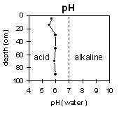 | 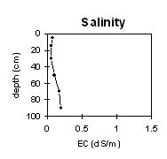 | 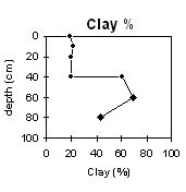 |
The whole profile is moderately acid throughout. | The profile has a very low to low salinity rating. | The clay content increases sharply at 40 cm depth. |
Chemical and Physical Analysis:
Horizon | Horizon Depth (cm) | pH (water) | pH (CaCl2) | EC dS/m | Organic Carbon % | Total Nitrogen % | Exchangeable Cations | Coarse Sand (0.2-2.0 mm) % | Fine Sand (0.02-0.2 mm) % | Silt (0.002-0.02 mm) % | Clay (<0.002 mm) % | Field Capacity % w/w | Wilting Point % w/w | |||
Ca | Mg | K | Na | |||||||||||||
meq/100g | ||||||||||||||||
A1 | 0-10 | 5.7 | 5.0 | 0.08 | 4.8 | 0.26 | 6.9 | 0.9 | 0.2 | 0.05 | 6 | 32 | 28 | 19 | 43 | 17 |
A21 | 10-20 | 5.5 | 4.7 | 0.06 | 3 | 1 | 0.2 | 0.05 | 5 | 37 | 29 | 21 | 34 | 12 | ||
A22 | 20-40 | 6.0 | 5.2 | 0.06 | 1.3 | 1.5 | 0.1 | 0.05 | 21 | 32 | 24 | 20 | 27 | 10 | ||
B21 | 40-60 | 6.0 | 5.2 | 0.1 | 2.8 | 6.5 | 0.2 | 0.8 | 4 | 12 | 9 | 61 | 50 | 31 | ||
B22 | 60-80 | 5.9 | 5.3 | 0.17 | 3.6 | 8.5 | <0.1 | 1.7 | 2 | 8 | 9 | 69 | 56 | 37 | ||
B23 | 80-100 | 6.0 | 5.3 | 0.2 | 4.8 | 9.9 | <0.1 | 2.1 | 11 | 28 | 12 | 43 | 50 | 28 | ||
Profile Described By: Mark Imhof and Austin Brown, August 1998.