Victorian Resources Online (archived)
SW9
Location: Nullawarre
Australian Soil Classification: Melacic, Parapanic, Semiaquic PODOSOL (f Grey KUROSOL) (thick sandy surface)
General Landscape Description: Lower-midslope of an undulating sandy rise.
Geology: Quaternary sand deposits overlying Tertiary (Port Campbell Limestone) sediments.
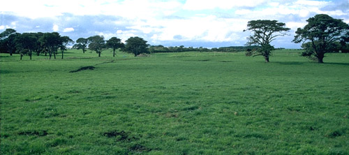
SW9 Landscape
Soil Profile Morphology:
| Surface Soil | 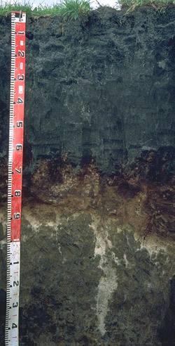 SW9 Profile | ||
| A1 | 0-30 cm | Black (10YR2/1) sandy loam; weakly structured; pH 5.1; clear change to: | |
| A2 | 30-60 cm | Black (10YR2/1) loamy sand; (peppered with bleached sand); pH 4.6; sharp change to: | |
| Subsoil | |||
| Bhs | 60-85 cm | Dark reddish brown (5YR3/2) coffee rock layer; strong consistence moderately moist; pH 5.4; clear change to: | |
| 2A | 85-90 cm | Dark brown (10YR3/3) with yellowish brown (10YR5/6) mottles; light sandy loam; very weak consistence moist; sharp change to: | |
| 2B21 | 90-130 cm | Dark greyish brown (10YR4/2) with dark yellowish brown (10YR4/6) mottles; sandy clay; moderate coarse blocky, parting to moderate medium blocky structure; moderately sticky consistence wet; fine sand pockets in discontinuous band to 100 cm, occasional piping after 100 cm; pH 5.4; clear change to: | |
| 2B22 | 130-160 cm | Greyish brown (10YR5/2) with dark yellowish brown (10YR4/6) mottles; sandy clay loam; slightly sticky consistence wet; pH 5.7. |
Key Profile Features:
- Thick sandy surface horizons.
- Zone of cemented sand ('coffee rock') formed within the A horizon of an older Kurosol.
pH | Salinity Rating | |
Surface (A1 horizon) | Strongly Acid | Low-Medium |
Upper Subsoil (2B21 horizon) | Strongly Acid | Very Low |
Deeper Subsoil (at 130-160 cm) | Moderately Acid | Very Low |
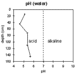 | 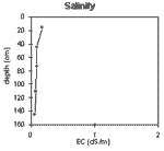 | 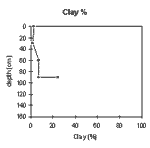 |  |
| The strongly acid surface horizon overlies the very strongly acid subsurface horizon. The soil horizons below the 'coffee rock' zone are moderately to strongly acid. | The level of soluble salts is very low throughout the soil profile. | The clay percentage increases in the deeper subsoil |
Chemical and Physical Analysis:
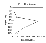
Horizon | Horizon Depth (cm) | pH (water) | pH (CaCl2) | EC dS/m | Exchangeable Cations | Coarse Sand (0.2-2.0 mm) % | Fine Sand (0.02-0.2 mm) % | Silt (0.002-0.02 mm) % | Clay (<0.002 mm) % | Wilting Point % w/w | |||
Ca | Mg | K | Na | ||||||||||
meq/100g | |||||||||||||
A1 | 0-30 | 5.1 | 4.1 | 0.18 | 5.3 | 0.76 | 0.34 | 0.60 | 41.1 | 43.7 | 4.5 | 2.5 | 8.3 |
A2 | 30-60 | 4.6 | 3.7 | 0.09 | 1.5 | 0.34 | 0.08 | 0.24 | 43.4 | 48.4 | 5.0 | 1.5 | 2.1 |
Bhs | 60-85 | 5.4 | 4.4 | 0.09 | 36.6 | 43.2 | 3.5 | 7.0 | |||||
2B21 | 90-130 | 5.4 | 4.3 | 0.08 | 1.1 | 3.1 | 0.30 | 0.52 | 26.8 | 42.5 | 4.5 | 24.5 | |
2B22 | 130-160+ | 5.7 | 4.5 | 0.06 | |||||||||
Management Considerations:
Whole Profile
- Plant available water capacity (PAWC) is considered to be very low (estimated at 43 mm) for the soil profile. This is based on available laboratory data and assumes an effective rooting depth of 60 cm. Rooting depth will be restricted by the 'coffee rock' layer. Most of the plant available water (ie. 30 mm) is held in the surface (A1) horizon.
Surface (A) Horizons
- Lime may be needed to raise the pH of the strongly acid surface soil. Other factors need to be considered, however, before lime is recommended (eg. pasture species grown, method of application, local trial responses, likely cost-benefit).
- The sandy surface horizons are very well drained but have a low water storage capacity. The low wilting point value, however, indicates that plants will be able to utilise light rains falling on dry soil. However, due to the low storage capacity, plants will soon suffer moisture stress until further rain falls occur. Organic matter is important in these sandy soils to enhance water holding capacity.
- The sandy surface soil is prone to wind erosion if plant cover is removed and blow-outs can occur.
- The surface soil has a low inherent fertility (based on the sum of the basic exchangeable cations). Such strongly leached soils are also likely to be naturally deficient in nitrogen, phosphorus, sulphur and potassium. Regular fertiliser inputs are required for intensive cropping. Nitrate and sulphate are readily soluble and easily removed by leaching. More regular but smaller applications of fertiliser will assist in reducing loss of nutrients through leaching. Nutrients lost through leaching may influence catchment water quality.
- The sub-surface (A2) horizons have a very low inherent fertility, so building up the surface (A1) soil should be a prime objective.
- Lime application will result in increased pH levels and make certain nutrients such as phosphorus more available to plants. Many vegetables prefer a pH closer to 6.5 (see Appendix A-3). Burnt lime is preferred when planting Brassica species or when a rapid pH change is required (pers. comm. Geoff Morrow).
- Deficiencies of the trace element molybdenum (Mo) are likely to occur in acid sandy soils (soil adsorption of Mo increases as pH decreases, leading to reduced availability to plants). U.S.A. research has found that the following vegetables can be susceptible to molybdenum deficiency: Brassica species (eg. cauliflower, broccoli and cabbage), lettuce and tomato (Clark 1984). Any deficiencies can be confirmed by plant tissue analysis. Deficiencies can be remedied with molybdenum enriched fertiliser and foliar application. Lime application on acid soils will also make molybdenum more available to plants.
- Nutrients such as calcium and magnesium are usually low in strongly acid soils. Magnesium deficiency has been found to affect vegetables such as tomatoes, potatoes and cauliflowers (NSW Dept. Agric. 1987). Magnesium deficiency can be assessed by plant tissue analysis and can be treated by applying dolomite to the soil or using a foliar spray. Calcium deficiency can affect vegetable crops such as tomatoes, lettuce, celery, brussels sprouts and potatoes (NSW Dept. Agric. 1987). Foliar spray application, adjusting soil pH with lime application or using calcium based fertilisers can be utilised to treat deficiencies.
- The trace element boron (B) leaches rapidly through acid sandy soils and deficiencies are likely to occur. Susceptible crops include cauliflower, cabbage and celery (NSW Dept. Agric. 1986). Over-liming in sandy soils can make trace elements such as boron, zinc and manganese less available. Organic matter can complex with metal ions enabling trace elements (Fe, Zn, Cu) to become more available to plants.
- Organic matter is an important source of nutrient holding capacity in sandy soils. Levels of organic matter are often low in continually cropped vegetable growing soils and inputs such as poultry manure are often recommended.
- The subsurface (A2) horizon has a very low nutrient status (based on the sum of the exchangeable basic cations)
Subsoil (B) Horizons
- The 'coffee rock' layer will restrict the movement of water and plant roots.
- Horizons below 'coffee rock' zone are sodic and dispersive and likely to be poorly permeable. This will further restrict movement of water down the soil profile.
Profile Described By: Mark Imhof, Austin Brown, Graeme Ward and Ruth Lourey (April 1996).