Victorian Resources Online (archived)
LWA1
| Location: Chinkapook | Australian Soil Classification: Epibasic, Pedal, Hypercalcic CALCAROSOL |
| General Landscape Description: Crest of east-west dune | Site Description: Landcare delivery site |
| Geology:Quaternary Aeolian deposits (Woorinen Formation) |
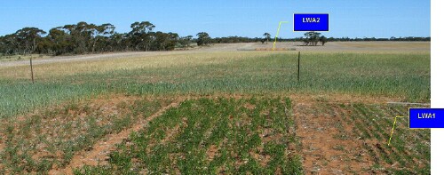 LWA1 Landscape |
Soil Profile Morphology:
Surface Soil
| A11 | 0-10 cm | Brown (7.5YR4/4); loamy sand; soft surface condition; apedal; pH 7.2; clear change to: | 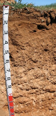 LWA1 Profile |
| A12 | 10-15 cm | Brown (7.5YR4/4); light sandy loam; apedal; pH 7.6; clear change to: | |
Subsoil | |||
| B1 | 15-25 cm | Yellowish red (5YR4/6); sandy clay loam; firm to very firm consistence (dry); few (5%) fine-earth carbonates; visible effervescence; evidence of compaction at 15-22 cm; macropores present pH 8.2; clear change to: | |
| B21 | 25-40 cm | Yellowish red (5YR5/6); sandy clay; weak to moderate, coarse to fine (10–50 mm) subangular blocky structure; few (5%) fine-earth carbonates; pH 8.5; gradual change to: | |
| B22k | 40-70 cm | Reddish yellow (5YR6/6); sandy clay; weak to moderate, coarse to fine (5–50 mm) subangular blocky structure; many (40%) calcareous nodules (5-20 mm) and fine earth carbonates; pH 8.7; gradual change to: | |
| B23k | 70-110 cm | Yellowish red (5YR4/6); light sandy clay loam; many (40%) calcareous nodules (1 cm) and fine-earth carbonates; macropores present; pH 9.4; gradual change to: | |
| B24 | 110-140 cm | Red (2.5YR5/8); light sandy clay loam; firm to strong consistence (dry); few (10%) calcareous nodules with some hard carbonate/silica nodules (5 cm);very many small dark flecks; pH 9.8. | |
Key Profile Features:
- Gradual increase in texture (i.e. Clay content) with depth down the profile.
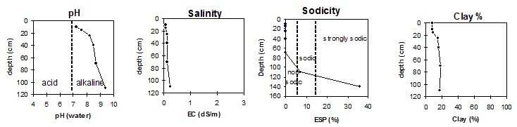
pH | Salinity Rating | |||
Surface (Ap horizon) | Slightly alkaline | Very low | Non-sodic | None |
Subsoil (B21 horizon) | Moderately alkaline | Very low | Non-sodic | None |
Deeper subsoil (at 110-140 cm) | Extremely alkaline | Medium | Strongly sodic | Strong |
 |
Horizon | Horizon Depth | pH (water) | pH CaCl2 | EC 1:5 | Org. Carbon mg/kg | Exchangeable Cations | |||
Ca | Mg | K | Na | ||||||
Meq/100g | |||||||||
A11 | 0-10 | 7.2 | 6.8 | 0.07 | 0.46 | 4.5 | 1.0 | 1.0 | 0.1 |
A12 | 10-15 | 7.6 | 7.2 | 0.07 | 0.37 | 5 | 1.1 | 0.8 | 0.1 |
B1 | 15-25 | 8.2 | 7.7 | 0.11 | 11 | 2.1 | 1.2 | 0.1 | |
B21 | 25-40 | 8.5 | 8.0 | 0.12 | 23 | 3.3 | 0.8 | 0.1 | |
B22K | 40-70 | 8.7 | 8.1 | 0.12 | 21 | 5.1 | 0.5 | 0.3 | |
B23K | 70-110 | 9.4 | 8.5 | 0.23 | 19 | 7.1 | 0.8 | 2.1 | |
B3 | 110-140 | 9.8 | 8.9 | 0.39 | 2 | 4.5 | 1.1 | 4.3 | |
Horizon | Horizon Depth | Boron mg/kg | Field pF2.5 g/100g | Wilting Point pF4.2 g/100g | Coarse Sand (0.2-2.0mm) % | Fine Sand (0.02-0.2mm) % | Silt (0.002-0.02mm) % | Clay (<0.002mm) % |
A11 | 0-10 | 0.7 | 9.8 | 2.4 | 56 | 34 | 3 | 8 |
A12 | 10-15 | 0.6 | 9.7 | 2.6 | 57 | 31 | 3 | 9 |
B1 | 15-25 | 0.8 | 17.0 | 5.6 | 47 | 30 | 8 | 15 |
B21 | 25-40 | 0.8 | 22.3 | 7.3 | 39 | 30 | 7 | 16 |
B22K | 40-70 | 0.9 | 24.0 | 8.4 | 35 | 26 | 5 | 18 |
B23K | 70-110 | 3.9 | 21.2 | 8.5 | 36 | 28 | 5 | 17 |
B3 | 110-140 | 10.0 |
Note:
- Soil characterised by