Victorian Resources Online (archived)
LWA2
| Location: Chinkapook | Australian Soil Classification: Endohypersodic, Pedal, Hypercalcic CALCAROSOL |
| General Landscape Description: Swale between east-west dune | Site Description: Landcare selivery site |
| Geology: Quaternary Aeolian deposits (Woorinen Formation) |
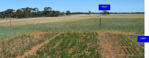 LWA2 Landscape |
Soil Profile Morphology:
Surface Soil
| A11 | 0-10 cm | Dark brown (7.5YR3/3); sandy loam; weak to moderate medium (10 – 20 mm) blocky structure; very weak consistence (dry); visible effervescence; pH 8.5; clear change to: | 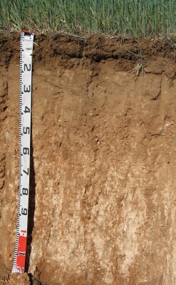 LWA2 Profile |
| A12 | 10-16 cm | Dark brown (7.5YR3/3); sandy loam; very weak to weak consistence (dry); pH 8.5; abrupt change to: | |
| Subsoil | |||
| B21 | 16-35 cm | Brown (7.5YR4/4); sandy clay loam; weak very coarse (>50 mm) blocky structure; weak to firm consistence (dry); few (2%) carbonate nodules (5-15 mm); pH 8.6; clear change to: | |
| B22 | 35-50 cm | Strong brown (7.5YR5/6); sandy clay; weak consistence (dry) many (20%) calcareous nodules (5-20 mm) and fine-earth carbonates; pH 8.8; gradual change to: | |
| B23k | 50-70 cm | Yellowish red (5YR5/8); sandy clay; moderate coarse (20-50 mm) blocky structure; very many (40%) fine-earth carbonates and semi-hard calcareous nodules (5-20 mm); pH 9.3; gradual change to: | |
| B24k | 70-110 cm | Red (2.5YR5/8); sandy clay; moderate to strong medium (20-50 mm) subangular blocky structure; very many (50%) fine-earth carbonates and carbonate/silica nodules (5-40 mm); pH 9.7; gradual change to: | |
| B25 | 110+ cm | Red (2.5YR5/8); light medium clay (sandy); moderate medium (20-50 mm) subangular blocky structure; fine dark stains; pH 9.7. |
Key Profile Features:
- Gradual increase in texture (i.e. Clay contrast with depth down the profile).
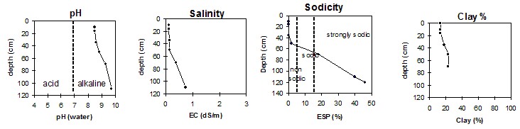
pH | Salinity Rating | |||
Surface (Ap horizon) | Moderately alkaline | Low | Non-sodic | None |
Subsoil (B21 horizon) | Strongly alkaline | Low | Non-sodic | None |
Deeper subsoil (at 110+ cm) | Extremely alkaline | High | Strongly sodic | Strong |
- 1 Moderate dispersion after remoulding.
2 Complete dispersion after remoulding.
3 Lack of dispersion probably due to high level of soluble salts.
 |
Horizon | Horizon Depth | pH (water) | pH CaCl2 | EC 1:5 | Org. Carbon mg/kg | Exchangeable Cations | |||
Ca | Mg | K | Na | ||||||
Meq/100g | |||||||||
A11 | 0-10 | 8.5 | 8.0 | 0.11 | 0.61 | 18 | 1.4 | 1.4 | 0.1 |
A12 | 10-16 | 8.5 | 8.0 | 0.12 | 0.53 | 20 | 1.6 | 1.4 | 0.1 |
B21 | 16-35 | 8.6 | 8.1 | 0.15 | 24 | 2.8 | 1.4 | 0.2 | |
B22 | 35-50 | 8.8 | 8.1 | 0.15 | 23 | 5.3 | 0.7 | 0.6 | |
B23K | 50-70 | 9.3 | 8.4 | 0.39 | 4 | 5.2 | 0.8 | 2.3 | |
B24K | 70-110 | 9.7 | 8.7 | 0.73 | 2 | 4.4 | 1.1 | 4.9 | |
B25 | 110+ | 9.7 | 8.9 | 0.86 | 1 | 4.6 | 1.4 | 6.4 | |
Horizon | Horizon Depth | Boron mg/kg | Field pF2.5 g/100g | Wilting Point pF4.2 g/100g | Coarse Sand (0.2-2.0mm) % | Fine Sand (0.02-0.2mm) % | Silt (0.002-0.02mm) % | Clay (<0.002mm) % |
A11 | 0-10 | 1.2 | 11.1 | 3.6 | 54 | 30 | 3 | 13 |
A12 | 10-16 | 1.4 | 13.1 | 3.7 | 54 | 27 | 5 | 13 |
B21 | 16-35 | 1.3 | 24.2 | 8.8 | 36 | 25 | 8 | 18 |
B22 | 35-50 | 1.6 | 25.8 | 9.8 | 30 | 21 | 5 | 23 |
B23K | 50-70 | 4.6 | 24.1 | 9.6 | 29 | 19 | 4 | 23 |
B24K | 70-110 | 18.0 | 23.2 | 10.6 | ||||
B25 | 110+ | 22.0 |
Note:
- Soil characterised by