Victorian Resources Online (archived)
LWA5
| Location: Cowangie | Australian Soil Classification: Endohypersodic, Petrocalcic, Lithocalcic CALCAROSOL |
| General Landscape Description: Surface between east-west dunes | Site Description: Stubble paddock |
| Geology: Quaternary aeolian deposits (Woorinen formation) |
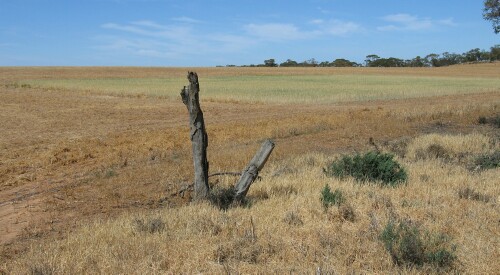 LWA5 Landscape |
Soil Profile Morphology:
Surface Soil
| A1 | 0-12 cm | Brown (7.5YR4/3); light sand; apedal; pH 8.2; some calcareous fragments at surface; abrupt change to: | 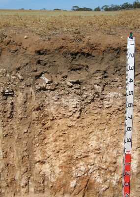 LWA5 Profile |
| Subsoil | |||
| B2 | 12-30 cm | Dark brown (7.5YR3/2); fine sandy clay loam; weak to firm consistence (dry); many roots present; pH 8.8; wavy and abrupt change to: | |
| Ck | 30-60 cm | Layered calcrete; gradual and wavy change to: | |
| D1k | 60-85 cm | Reddish yellow (7.5YR6/6); sandy clay loam; firm consistence (dry); very many (60%) fine-earth carbonates and some semi-hard calcareous nodules; pH 9.2; gradual change to: | |
| D2k | 85-120 cm | Reddish yellow (7.5YR6/6); sandy clay loam; very many (50%) fine-earth carbonates; pH 9.4; clear and wavy change to: | |
| D3k | 120+ cm | Yellowish red (5YR5/8) with light yellowish brown (10YR6/4) mottles; few (5%) semi-hard calcareous nodules and very few (2%) manganese stains; pH 9.2. | |
Key Profile Features:
- Shallow soil profile overlying hard calcrete layer.
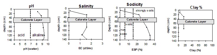
pH | Salinity Rating | |||
Surface (Ap horizon) | Moderately alkaline | Low | Non-sodic | None |
Subsoil (B2 horizon 12-30 cm) | Strongly alkaline | Extremely high | Strongly sodic | None1 |
Deeper subsoil (120+ cm) | Very strongly alkaline | Extremely high | Strongly sodic | Slight2 |
 |
Horizon | Horizon Depth | pH (water) | pH CaCl2 | EC 1:5 | Org. Carbon mg/kg | Exchangeable Cations | |||
Ca | Mg | K | Na | ||||||
Meq/100g | |||||||||
A1 | 0-12 | 8.2 | 7.7 | 0.1 | 0.61 | 6.4 | 0.7 | 0.7 | 0.1 |
B2 | 12-30 | 8.8 | 8.3 | 1.6 | 0.95 | 7.6 | 4.4 | 1.7 | 3.8 |
Ck | Calcrete layer | ||||||||
D1k | 60-85 | 9.2 | 8.7 | 1.6 | 2.2 | 4.0 | 0.8 | 3.2 | |
D2k | 85-120 | 9.4 | 8.7 | 1.2 | 1.5 | 3.7 | 0.8 | 3.2 | |
D3k | 120+ | 9.2 | 8.7 | 16.0 | 1.4 | 3.7 | 0.9 | 3.3 | |
Horizon | Horizon Depth | Boron mg/kg | Field pF2.5 g/100g | Wilting Point pF4.2 g/100g | Coarse Sand (0.2-2.0mm) % | Fine Sand (0.02-0.2mm) % | Silt (0.002-0.02mm) % | Clay (<0.002mm) % |
A1 | 0-12 | 0.6 | 30.1 | 2.6 | 45 | 44 | 3 | 4 |
B2 | 12-30 | 3.9 | 21.9 | 10.5 | 26 | 34 | 7 | 16 |
Ck | Calcrete layer | |||||||
D1k | 60-85 | 16.0 | 22.5 | 8.1 | 29 | 23 | 9 | 16 |
D2k | 85-120 | 16.0 | 16.1 | 9.1 | ||||
D3k | 120+ | 15.0 | ||||||
Note:
- Soil characterised by Jan 04.