Victorian Resources Online (archived)
LWA6
| Location: Cowangie | Australian Soil Classification: Epibasic, Pedal, Supracalcic, CALCAROSOL |
| General Landscape Description: Upper Slope | Site Description: Landcare Delivery Site |
| Geology: Quaternary aeolian deposits (Woorinen formation) |
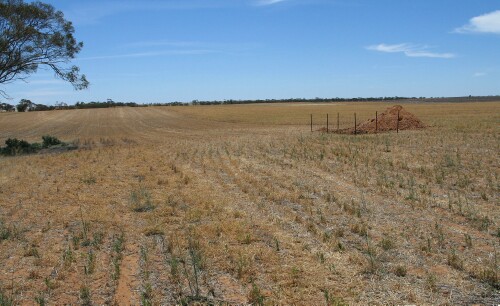 LWA6 Landscape |
Soil Profile Morphology:
Surface Soil
| A1 | 0-12 cm | Brown (7.5YR4/4); loamy sand pH 7.6: | 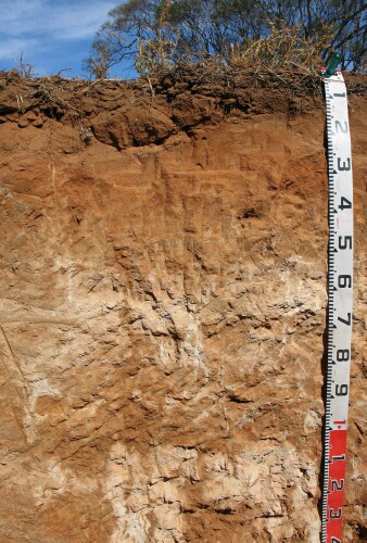 LWA6 Profile |
| A2 | 12-20 cm | Yellowish red (5YR4/6); loamy sand; firm consistence (dry); wavy change to; pH 8.1: | |
| Subsoil | |||
| B1 | 20-45 cm | Yellowish red (5YR5/8); sandy loam (clayey); weak to moderate coarse (20-50 mm) subangular blocky structure; very firm consistence (dry); pH 8.7: | |
| B21k | 45-80 cm | Yellowish red (5YR5/8); sandy clay loam; moderate coarse to very coarse (20 - <50 mm) blocky structure; very firm consistence (dry); very many (50%) fine earth carbonates and semi-hard calcareous nodules; pH 9.5: | |
| B22 | 80-100 cm | Yellowish red (5YR5/8) with brownish yellow (10YR6/6) mottles; sandy loam(clayey); moderate coarse to medium (10-50 mm) blocky structure; firm to very firm consistence (dry); many (20%) hard and semi-hard calcareous nodules and fine-earth carbonates; pH 9.8: | |
| B23k | 100-120 cm | Reddish yellow (7.5YR6/6) with red (2.5YR5/8); sandy clay loam; moderate coarse to medium (10-50 mm) subangular blocky structure; very many (50%) hard and semi-hard calcareous nodules and fine-earth carbonates; pH9.9: | |
| B24 | 120+ cm | Reddish yellow (7.5YR6/6) with yellowish red (5YR5/6) mottles; sandy clay loam; medium moderate to coarse (10-50 mm) subangular blocky structure. |
Key Profile Features:
- Gradual increase in texture contrast (i.e. Clay percentage) with depth down the profile.
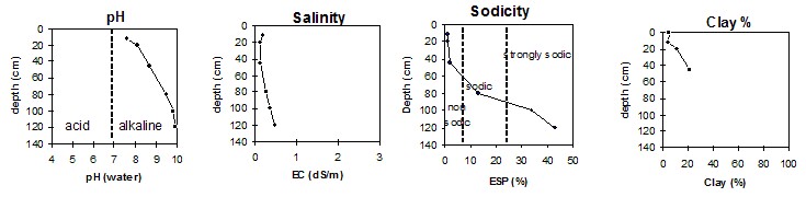
pH | Salinity Rating | |||
Surface (Ap horizon) | Slightly alkaline | Low | Non-sodic | None |
Subsoil (B21 horizon) | Very slightly alkaline | Low | Sodic | Moderate 1 |
Deeper subsoil (at cm) | Extremely alkaline | Medium | Strongly sodic | Strong - Complete |
- 1 Strong dispersion after remoulding.
 |
Horizon | Horizon Depth | pH (water) | pH CaCl2 | EC 1:5 | Org. Carbon mg/kg | Exchangeable Cations | |||
Ca | Mg | K | Na | ||||||
Meq/100g | |||||||||
A1 | 0-12 | 7.6 | 7.3 | 0.2.0 | 1.1 | 6.5 | 1.5 | 1.2 | 0.2 |
A2 | 12-20 | 8.1 | 7.7 | 0.11 | 4.3 | 1.2 | 0.6 | 0.1 | |
B1 | 20-45 | 8.7 | 8.2 | 0.13 | 12.0 | 3.6 | 1.0 | 0.2 | |
B21k | 45-80 | 9.5 | 8.7 | 0.26 | 3.4 | 5.3 | 1.1 | 2.0 | |
B22 | 80-100 | 9.8 | 9.0 | 0.36 | 1.8 | 3.6 | 1.0 | 3.3 | |
B23k | 100-120 | 9.9 | 8.9 | 0.48 | |||||
B24 | 120+ | 9.9 | 9.0 | 0.48 | 1.5 | 3.7 | 1.2 | 4.8 | |
Horizon | Horizon Depth | Boron mg/kg | Field pF2.5 g/100g | Wilting Point pF4.2 g/100g | Coarse Sand (0.2-2.0mm) % | Fine Sand (0.02-0.2mm) % | Silt (0.002-0.02mm) % | Clay (<0.002mm) % |
A1 | 0-12 | 0.9 | 5.8 | 3.4 | 57 | 30 | 7 | 5 |
A2 | 12-20 | 0.6 | 4.9 | 2.2 | 55 | 36 | 3 | 4 |
B1 | 20-45 | 2.1 | 15.2 | 6.6 | 44 | 33 | 9 | 11 |
B21k | 45-80 | 8.6 | 19.9 | 9.3 | 35 | 33 | 3 | 21 |
B22 | 80-100 | 10.0 | 18.1 | 7.5 | ||||
B23k | 100-120 | 11.0 | ||||||
B24 | 120+ |
Note:
- Soil characterised by Jan 04.