Victorian Resources Online (archived)
LWA7
| Location: Cowangie | Australian Soil Classification: Lithocalcic, Mottled-Mesonatric, Red SODOSOL |
| General Landscape Description: Depression | Site Description: Landcare delivery site |
| Geology:Quaternary aeolian deposits (Woorinen formation) |
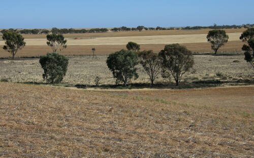 LWA7 Landscape |
Soil Profile Morphology:
Surface Soil
| A1 | 0-18 cm | Dark brown (7.5YR3/3); sandy loam; apedal; weak consistence (dry); pH 8.4; clear change to: | 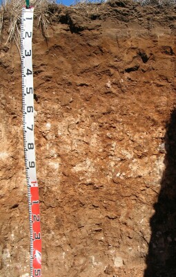 LWA7 Profile |
| Subsoil | |||
| B1 | 18-40 cm | Brown (7.5YR4/4); fine sandy clay loam; weak structure; firm structure (dry); pH 8.7; clear change to: | |
| B21k | 40-60 cm | Yellowish red (5YR4/6) with brown (7.5YR4/4) mottles; light clay (sandy); very many (50%) soft and semi-hard calcareous nodules; pH 8.7; gradual change to: | |
| B22k | 60-100 cm | Reddish brown (5YR4/4); light clay (sandy); moderate coarse to medium (10-50 mm) subangular blocky; very many (50%) soft and semi-hard calcareous nodules; pH 8.9; clear change to: | |
| B23 | 100+ cm | Reddish yellow (5YR6/6) with light brownish grey (10YR6/2) mottles; strong coarse (50-100 mm) prismatic, parting to strong coarse to medium (10-50 mm) blocky structure; few (5%) soft calcareous nodules; pH 9.1. | |
Key Profile Features:
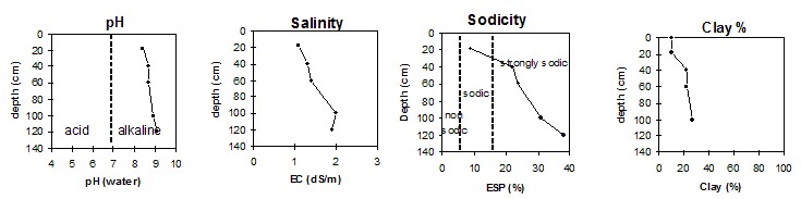
Soil Profile Characteristics:
pH | Salinity Rating | |||
Surface (A1 horizon) | Moderately alkaline | Very high | Sodic | None 1 |
Subsoil (B21 horizon 40-60 cm) | Strongly alkaline | Extremely high | Strongly sodic | None 1 |
Deeper subsoil (100+ cm) | Very strongly alkaline | Extremely high | Strongly sodic | None 1 |
- 1 Due to high levels of soluble salts.
 |
Horizon | Horizon Depth | pH (water) | pH CaCl2 | EC 1:5 | Org. Carbon mg/kg | Exchangeable Cations | |||
Ca | Mg | K | Na | ||||||
Meq/100g | |||||||||
A1 | 0-18 | 8.4 | 8.0 | 1.1 | 1.3 | 8.1 | 1.3 | 1.7 | 1.1 |
B1 | 18-40 | 8.7 | 8.2 | 1.3 | 9.4 | 3.0 | 1.1 | 3.7 | |
B21k | 40-60 | 8.7 | 8.3 | 1.4 | 8.6 | 3.7 | 1.1 | 4.2 | |
B22k | 60-100 | 8.9 | 8.5 | 2.0 | 4.5 | 5.6 | 1.5 | 5.1 | |
B23 | 100+ | 9.1 | 8.6 | 1.9 | 3.5 | 7.8 | 1.7 | 8.1 | |
Horizon | Horizon Depth | Boron mg/kg | Coarse Sand (0.2-2.0mm) % | Fine Sand (0.02-0.2mm) % | Silt (0.002-0.02mm) % | Clay (<0.002mm) % |
A1 | 0-18 | 1.5 | 41 | 39 | 3 | 10 |
B1 | 18-40 | 1.4 | 33 | 30 | 9 | 22 |
B21k | 40-60 | 3.3 | 32 | 27 | 10 | 22 |
B22k | 60-100 | 18.0 | 27 | 16 | 5 | 27 |
B23 | 100+ | 21.0 |
Note:
- Soil characterised by Jan 04.