Victorian Resources Online (archived)
MP41
| Location: Nullawil. | Australian Soil Classification: Bleached-Sodic, Calcic, Grey, DERMOSOL (clayey surface). |
| Geology: Quaternary alluvial & aeolian sediments. | General Landscape Description: Level plain (floodplain of Tyrell Creek). |
| Site Description: Cropping paddock. |
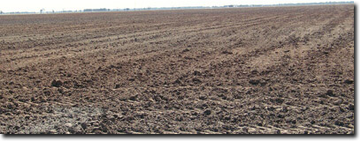 Site MP41 Landscape |
Soil Profile Morphology:
Surface Soil
| Ap | 0-8 cm | Very dark greyish brown (10YR3/2); light clay; soft surface condition; weak consistence (dry); pH 7.4: | 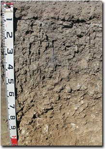 Site MP41 Profile |
| A12 | 8-10 cm | Brown (10YR5/3) conspicuously bleached (10YR7/1 dry); heavy sandy clay loam; firm consistence (dry); pH 8.1: | |
| Subsoil | |||
| B21 | 10-30 cm | Light brownish grey (10YR6/2) with few (5%) faint brownish yellow (10YR6/6) mottles; medium clay; moderate coarse prismatic, parting to strong coarse to medium blocky structure; strong consistence (dry); pH 8.3: | |
| B22 | 30-50 cm | Greyish brown (10YR5/2); medium heavy clay; strong coarse to medium blocky structure; strong consistence (dry); few (5%) medium (3-10 mm) calcareous nodules; pH 9.4: | |
| B23k | 50-80 cm | Reddish yellow (7.5YR7/6); medium heavy clay; fine-earth carbonates and calcareous nodules common (15%); pH 9.8: | |
| B24k | 80-100 cm | Reddish yellow (7.5YR7/6); medium clay; fine-earth carbonates common (15%); pH 9.8: | |
| B25 | 100-140 cm | Reddish yellow (7.5YR7/6); medium clay; very few (2%) manganese stains; pH 9.8. |
Key Profile Features:
- Lack of strong texture contrast between surface (A) horizons and subsoil (B21) horizon.
- Clayey surface horizons.
- Fine-earth carbonates common in deeper subsoil.
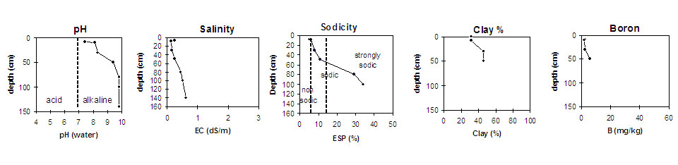
pH | Salinity Rating | |||
Surface (Ap horizon) | Slightly Alkaline | Low | Non-Sodic | None1 |
Subsoil (B21 horizon) | Strongly Alkaline | Low | Sodic | Moderate |
Deeper subsoil (at 100-140 cm) | Very Strongly Alkaline | Very High | Strongly Sodic | strong |
 | ||||
Horizon | Horizon Depth (cm) | pH (water) | pH (CaCl2) | EC 1:5 | NaCI % | Exchangeable Cations | Boron (CaCl2) mg/kg | Field Capacity pF2.5 | Wilting Point pF4.2 | Coarse Sand (0.2 - 2 mm) | Fine Sand (0.02 - 0.2 mm) | Silt (0.002 - 0.02 mm) | Clay (<0.002 mm) | |||
Ca | Mg | K | Na | |||||||||||||
meq/100g | ||||||||||||||||
Ap | 0-8 | 7.4 | 6.9 | 0.24 | 12 | 5.3 | 1.6 | 0.85 | 2.3 | 24 | 13 | 25 | 28 | 9 | 32 | |
A2 | 8-10 | 8.1 | 7.2 | 0.13 | 9.2 | 4.3 | 0.68 | 0.92 | 1.7 | 22 | 11 | 28 | 27 | 11 | 32 | |
B21 | 10-30 | 8.3 | 7.4 | 0.16 | 13 | 7 | 0.98 | 1.7 | 2.5 | 31 | 16 | 22 | 20 | 9 | 46 | |
B22 | 30-50 | 9.4 | 8.4 | 0.25 | 18 | 8.7 | 1.1 | 3.3 | 5.6 | 39 | 18 | 23 | 19 | 7 | 46 | |
B23k | 50-80 | 9.8 | 9.5 | 0.44 | <0.01 | 6.4 | 11 | 1.4 | 7.7 | 47 | 20 | |||||
B24k | 80-100 | 9.8 | 9.4 | 0.52 | 0.01 | 5.4 | 11 | 1.4 | 9.0 | |||||||
B25 | 100-140 | 9.8 | 9.5 | 0.62 | 0.03 | |||||||||||
Profile Described By: Mark Imhof, April 2004.