Victorian Resources Online (archived)
MP42
| Location: Nullawil. | Australian Soil Classification: Epihypersodic, Pedal, Hypercalcic, CALCAROSOL (loamy surface). |
| Geology: Quaternary alluvial & aeolian deposits. | General Landscape Description: Level plain with gilgai microrelief. |
| Site Description: Cropping paddock (with barley stubble). |
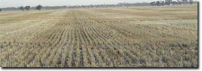 Site MP42 Landscape |
Soil Profile Morphology:
Surface Soil
| Ap | 0-5 cm | Brown (7.5YR4/2); sandy clay loam; soft surface condition; weak-moderate medium to fine polyhedral structure; very weak to weak consistence (dry); moderately calcareous; pH 8.4; sharp change to: | 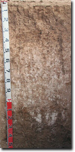 Site MP42 Profile |
| Subsoil | |||
B21 | 5-15 cm | Brown (7.5YR4/4); sandy clay; weak-moderate very coarse prismatic, parting to weak-moderate coarse to medium blocky structure; very firm consistence (dry); moderately calcareous; pH 8.7; clear change to: | |
B22 | 15-30 cm | Brown (7.5YR4/4); sandy clay; weak-moderate very coarse prismatic structure; firm to very firm consistence (dry); moderately calcareous; pH 8.7; clear change to: | |
B23k | 30-45 cm | Yellowish red (5YR5/6); light medium clay (sandy); weak-moderate very coarse prismatic structure; firm to very firm consistence (dry); fine-earth carbonates common (20%); pH 9.4; gradual change to: | |
B24k | 45-110 cm | Reddish yellow (5YR6/6); light medium clay (sandy); weak-moderate coarse to medium polyhedral structure; firm consistence (dry); very many (80%) fine-earth carbonates; pH 10.0; clear and irregular change to: | |
B25k | 110-130 cm | No sample taken. | |
B3 | 130+ cm | Light brownish grey (2.5Y6/2) with many (40%) reddish brown (5YR5/4) mottles; medium heavy clay; strong coarse to medium polyhedral structure (smooth-faced peds); few (5%) manganese flecks; pH 9.6. |
Key Profile Features:
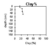
- Gradual increase in texture (clay content) with depth down the soil profile.
- Very many fine-earth carbonates in deeper subsoil.
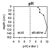
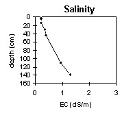
pH | Salinity Rating | |||
Surface (Ap horizon) | Moderately Alkaline | Low | Non-Sodic | None |
Subsoil (B21 horizon) | Strongly Alkaline | Low | Non-Sodic | None |
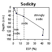
Deeper subsoil (at 45-110 cm) | Very Strongly Alkaline | High | Strongly Sodic | Moderate |
 |  |  | |
 | 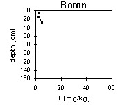 |
Horizon | Horizon Depth (cm) | pH (water) | pH (CaCl2) | EC 1:5 | NaCI % | Exchangeable Cations | Boron (CaCl2) mg/kg | Field Capacity pF2.5 | Wilting Point pF4.2 | Coarse Sand (0.2 - 2.0 mm) | Fine Sand (0.02 -0.2 mm) | Silt (0.002 -0.02 mm) | Clay (<0.002 mm) | |||
Ca | Mg | K | Na | |||||||||||||
meq/100g | ||||||||||||||||
Ap | 0-5 | 8.4 | 8.0 | 0.22 | 24 | 2.9 | 2.4 | 0.22 | 2.6 | 21 | 10 | 37 | 27 | 15 | 16 | |
B21 | 5-15 | 8.7 | 8.2 | 0.23 | 27 | 5.4 | 1.6 | 0.58 | 2.4 | 27 | 14 | 31 | 24 | 18 | 23 | |
B22 | 15-35 | 8.7 | 8.2 | 0.35 | <0.01 | 17 | 7.2 | 1.5 | 1.0 | 27 | 15 | 35 | 20 | 13 | 24 | |
B23k | 35-45 | 9.4 | 8.6 | 0.40 | 0.03 | 9.3 | 9.2 | 0.9 | 3.0 | 5 | 29 | 15 | 31 | 18 | 5 | 26 |
B24k | 45-110 | 10 | 9.1 | 0.93 | 0.11 | 2.1 | 8.1 | 1.3 | 8.1 | 31 | 16 | |||||
B25k | 110-130 | |||||||||||||||
B3 | 130+ | 9.6 | 9.5 | 1.3 | 0.07 | 2.4 | 13 | 2.1 | 12 | |||||||
Notes: Most roots observed to 40 cm depth.
Profile Described By: Mark Imhof, April 2004.