Victorian Resources Online (archived)
MP45
| Location: Watchupga. | |
| Australian Soil Classification: Hypercalcic, Subnatric, Red, SODOSOL (loamy surface). | |
| Geology: Quaternary alluvial and aeolian deposits (Woorinen Formation). | General Landscape Description: Plain with sandy rises. |
| Site Description: Cropping paddock (wheat, vetch). | |
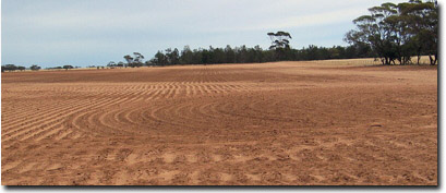 Site MP45 Landscape |
Soil Profile Morphology:
Surface Soil
| Ap | 0-10 cm | Dark reddish brown (5YR3/3); light sandy clay loam; soft surface condition; weak consistence (dry); non-calcareous; pH 7.4; clear change to: | 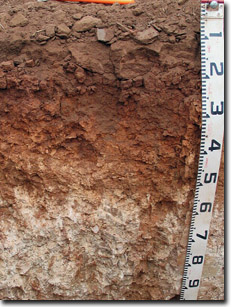 Site MP45 Profile |
A12 | 10-15 cm | Dark reddish brown (5YR3/3); sandy clay loam; massive; very firm to strong consistence (dry); forms a hardpan; non-calcareous; pH 8.1; sharp change to: | |
Subsoil | |||
B21 | 15-30 cm | Yellowish red (5YR5/8); medium heavy clay; strong coarse to medium subangular blocky structure; strong consistence (dry); few (5%) fine-earth carbonates; moderately calcareous; pH 9.1; gradual change to: | |
B22k | 30-55 cm | Yellowish red (5YR5/8); medium clay; moderate coarse to medium subangular blocky structure; many (20%) fine-earth carbonates; pH 9.5 gradual change to: | |
B23k | 55-100 cm | Light grey (10YR7/2) with many (40%) yellowish red (5YR5/8) mottles; medium clay; moderate very coarse to coarse polyhedral structure; very many (60%) fine-earth carbonates and few (5%) calcareous-siliceous nodules (10-40 mm); pH 9.9; gradual change to: | |
B24k | 100-140 cm | Yellowish red (5YR5/8) with light grey (10YR7/2) mottles; medium clay; many (30%) fine-earth carbonates and few (5%) calcareous-silica nodules (10-20 mm); pH 9.9. |
Key Profile Features:
- Strong texture contrast between surface (A) horizons and subsoil (B21) horizon.
- Subsoil calcareous throughout, surface horizons non-calcareous.
- Very many fine-earth carbonates at 55 cm depth.
pH | Salinity Rating | |||
Surface (Ap horizon) | Slightly Alkaline | Low | Non-Sodic | None1 |
Subsoil (B21 horizon) | Very Strongly Alkaline | Low | Sodic | Some2 |
Deeper subsoil (at 100-140 cm) | Extremely Alkaline | High | Strongly Sodic | Moderate-Strong |
2Strong dispersion after remoulding
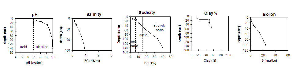 | |||
Horizon | Horizon Depth (cm) | pH (water) | pH (CaCl2) | EC 1:5 | NaCI % | Exchangeable Cations | Boron (CaCl2) mg/kg | Field Capacity pF2.5 | Wilting Point pF4.2 | Coarse Sand (0.2 - 2 mm) | Fine Sand (0.02 - 0.2 mm) | Silt (0.002 - 0.02 mm) | Clay (<0.002 mm) | |||
Ca | Mg | K | Na | |||||||||||||
meq/100g | ||||||||||||||||
Ap | 0-10 | 7.4 | 7.0 | 0.18 | 6.9 | 2.5 | 1.2 | 0.26 | 1.5 | 14 | 6 | 46 | 33 | 4 | 15 | |
A12 | 10-15 | 8.1 | 7.4 | 0.17 | 6.9 | 3.0 | 0.87 | 0.91 | 1.8 | 15 | 7 | 43 | 32 | 3 | 21 | |
B21 | 15-30 | 9.1 | 8.3 | 0.30 | 0.01 | 13 | 10 | 1.8 | 3.0 | 5.2 | 40 | 19 | 31 | 14 | 3 | 48 |
B22k | 30-55 | 9.5 | 8.7 | 0.49 | 0.03 | 9.2 | 13 | 1.8 | 5.1 | 14 | 47 | 22 | 23 | 12 | 3 | 51 |
B23k | 55-100 | 9.9 | 9.6 | 0.79 | 0.05 | 2.8 | 13 | 1.8 | 8.9 | 24 | ||||||
B24k | 100-140 | 9.9 | 9.5 | 0.93 | 0.11 | 2.4 | 9.6 | 1.7 | 9.0 | |||||||
Notes: Most roots evident to 45 cm depth.
Profile Described By: Mark Imhof, April 2004.