Victorian Resources Online (archived)
MP46
| Location: Birchip. | Australian Soil Classification: Epihypersodic, Pedal, Calcic, CALCAROSOL (clayey surface). |
| Geology: Quaternary alluvial and aeolian deposits. | General Landscape Description: Level plain. |
| Site Description: Cropping paddock (GRDC trial site). |
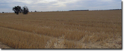 Site MP46 Landscape |
Soil Profile Morphology:
Surface Soil
| A1 | 0-10 cm | Reddish brown (5YR4/4); light clay; soft surface condition; very firm consistence (dry); slightly calcareous; pH 8.2; clear change to: | 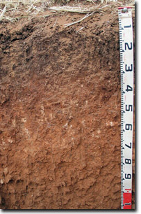 Site MP46 Profile |
| Subsoil | |||
B21 | 10-25 cm | Dark reddish brown (5YR3/3); light medium clay; strong medium to fine subangular blocky, parting to moderate very fine polyhedral structure; very firm consistence (dry); slightly calcareous; pH 9.1; clear change to: | |
B22k | 25-40 cm | Reddish brown (5YR4/4); light medium clay; strong-moderate very coarse to coarse prismatic, parting to strong coarse to medium subangular blocky structure; firm consistence (slightly moist); few (5-10%) fine-earth carbonates; pH 9.2; clear change to: | |
B23k | 40-65 cm | Reddish yellow (5YR6/8); light medium clay; weak-moderate very coarse to coarse prismatic, parting to strong coarse to medium blocky structure; macropores present; firm consistence (slightly moist); few (5-10%); fine-earth carbonates; pH 9.4; gradual change to: | |
B24 | 65-105 cm | Reddish yellow (5YR6/8); light medium clay (sandy); moderate coarse polyhedral structure; weak consistence (slightly moist); few (2-5%) fine-earth carbonates; pH 9.5: | |
B25 | 105+ cm | Reddish yellow (5YR6/6); medium heavy clay; strong consistence (moist); few (2-5%) fine-earth carbonates and few (2-5%) manganese flecks; pH 9.4. |
Key Profile Features:
- Lack of strong texture contrast between clayey surface horizon and subsoil (B21) horizon.
- Soil profile calcareous throughout.
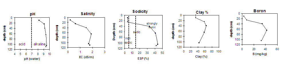
pH | Salinity Rating | |||
Surface (A1 horizon) | Moderately Alkaline | Low | Non-Sodic | None |
Subsoil (B21 horizon) | Very Strongly Alkaline | Medium | Non-Sodic | Slight-Moderate1 |
Deeper subsoil (at 105+ cm) | Very Strongly Alkaline | Very High | Strongly Sodic | None2 |
2 Probably due to high levels of soluble salts.
 | |||
Horizon | Horizon Depth (cm) | pH (water) | pH (CaCl2) | EC 1:5 | NaCI % | Exchangeable Cations | Boron (CaCl2) mg/kg | Field Capacity pF2.5 | Wilting Point pF4.2 | Coarse Sand (0.2 - 2.0 mm) | Fine Sand (0.02 -0.2 mm) | Silt (0.002 -0.02 mm) | Clay (<0.002 mm) | |||
Ca | Mg | K | Na | |||||||||||||
meq/100g | ||||||||||||||||
A1 | 0-10 | 8.2 | 7.7 | 0.21 | 20 | 4.4 | 2.2 | 0.94 | 2.7 | 38 | 15 | 25 | 25 | 12 | 34 | |
B21 | 10-25 | 9.1 | 8.4 | 0.63 | 0.09 | 20 | 4.8 | 2.7 | 1.0 | 8.2 | 51 | 24 | 18 | 16 | 2 | 58 |
B22k | 25-40 | 9.2 | 8.7 | 1.5 | 0.26 | 11 | 16 | 2.3 | 14 | 34 | 62 | 29 | 12 | 13 | 3 | 64 |
B23k | 40-65 | 9.4 | 9.3 | 1.9 | 0.33 | 6.7 | 14 | 2.3 | 16 | 42 | 59 | 28 | 10 | 12 | 4 | 58 |
B24 | 65-105 | 9.5 | 8.8 | 1.7 | 0.3 | 5.5 | 11 | 1.7 | 14 | 33 | 51 | 29 | 18 | 15 | 6 | 43 |
B25 | 105+ | 9.4 | 9.1 | 1.8 | 0.3 | 5.7 | 11 | 1.6 | 13 | |||||||
Notes: Most roots evident to 45 cm depth.
Profile Described By: Mark Imhof, April 2004.