Victorian Resources Online (archived)
ORZC14
| Location: Birchip. | Australian Soil Classification: Vertic (& Sodic), Calcic, Grey DERMOSOL. |
| Geology: Quaternary (Woorinen Formation). | General Landscape Description: Level plain. |
| Site Description: Grazing paddock. | Native Vegetation: Mallee (with Casuarina). |
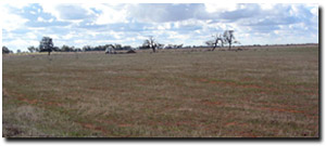 Site ORZC14 Landscape |
Soil Profile Morphology:
Surface Soil
| Ap | 0-12 cm | Dark greyish brown (10YR4/2); light clay; moderate coarse to medium blocky structure; hardsetting surface; firm to very firm consistence (dry); no surface cracking evident; non-calcareous; pH 7.6; clear change to: | 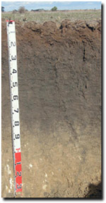 Site ORZC14 Profile |
| Subsoil | |||
| B21 | 12-40 cm | Dark grey (10YR4/1); medium clay; weak-moderate very coarse prismatic, parting to moderate-strong coarse to medium blocky and moderate fine blocky structure; non-calcareous; very firm to strong consistence (dry); pH 8.4; gradual change to: | |
| B22 | 40-90 cm | Dark grey (10YR4/1); fine sandy light clay; weak-moderate very coarse prismatic, parting to moderate coarse blocky structure; some slickensides present; moderately calcareous; strong consistence (dry); pH 9.1; gradual change to: | |
| B23k | 90-130 cm | Light yellowish brown (10YR6/4); light clay; moderate strong coarse to medium blocky structure; few (5-10%) soft and semi-hard carbonate segregations; moderately calcareous; firm consistence (dry); pH 9.3. | |
Key Profile Features:
- Clay texture throughout soil profile.
- Significant shrinking and swelling occurs during drying and wetting cycles.
- Vertic properties (i.e. slickensides) in subsoil.
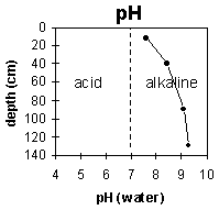
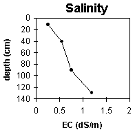
pH | Salinity Rating | |||
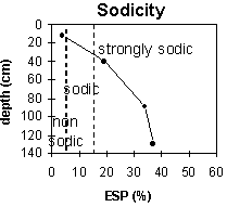
Surface soil (Ap horizon) | Slightly Alkaline | Low | Non-Sodic | None1 |
Upper subsoil 12-40 cm | Moderately Alkaline | Low-Medium | Strongly Sodic | Slight2 |
Deeper subsoil (at 40-90 cm) | Very Strongly Alkaline | High | Strongly Sodic | None2 |
Deep subsoil (at 90-130 cm) | Very Strongly Alkaline | High-Very High | Strongly Sodic | None2 |
 |  |  |
 | 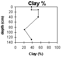 |
Horizon | Horizon Depth (cm) | pH (water) | pH (CaCl2) | EC 1:5 | NaCI % | Exchangeable Cations | Boron mg/kg | Field Capacity pF 2.5 | Wilting Point pF 4.2 | Coarse Sand (0.2 - 2.0 mm) | Fine Sand (0.02 -0.2 mm) | Silt (0.002 -0.02 mm) | Clay (<0.002 mm) | |||
Ca | Mg | K | Na | |||||||||||||
meq/100g | ||||||||||||||||
Ap | 0-12 | 7.6 | 7.1 | 0.26 | <0.01 | 13 | 4.5 | 2.1 | 0.8 | 1.6 | 30 | 15 | 23 | 26 | 9 | 38 |
B21 | 12-40 | 8.4 | 7.6 | 0.55 | 0.06 | 16 | 9.4 | 1.4 | 6.2 | 2.8 | 44 | 25 | 8 | 13 | 17 | 55 |
B22 | 40-90 | 9.1 | 8.3 | 0.75 | 0.11 | 9.1 | 8.1 | 1.2 | 9.2 | 6.5 | 42 | 21 | 17 | 23 | 35 | 22 |
B23k | 90-130 | 9.3 | 8.6 | 1.2 | 0.21 | 6.5 | 8.8 | 1.2 | 9.7 | 9.7 | 38 | 19 | 25 | 19 | 12 | 38 |
Management Considerations:
General
- Management strategies for all soils should aim to increase organic matter levels in the surface soil; minimise the degradation of soil aggregates and porosity; promote the development of stable biopores; improve the calcium status of the cation exchange complex (particularly when sodium is a significant part), and break up any hardpans. Less frequent tillage, using less aggressive implements, and working the soil at optimum moisture content can all assist in maintaining soil aggregation and porosity as well as reducing the breakdown of organic matter.
- Tillage of clayey soils like these, should be avoided if the soil is wet (i.e. wetter than the plastic limit). At such moisture conditions, excessive tillage, trafficking or over-stocking could result in some structural damage e.g. compaction. Ideally, tillage should take place on clayey soils when the soil is drier than the plastic limit – down to at least the tillage depth.
- The level of soluble salts becomes high in the deeper subsoil (i.e. from 40 cm depth). This is likely to restrict the growth of salt-sensitive species.
- The level of boron measured at this pit site is not as high as for the site nearby i.e. Site 13.
The subsoil displays vertic properties (i.e. slickensides), which indicates that significant shrinking and swelling occurs during drying and wetting cycles. - The deeper subsoil (from 40 cm depth) is very strongly alkaline. This indicates that phosphorus and some trace elements such as iron, manganese, copper and zinc may be poorly available to plants. Deficiencies can be determined by plant tissue analysis.
- The coarsely structured subsoil is strongly sodic throughout. The upper subsoil horizon disperses slightly. Dispersion in the deeper subsoil is suppressed by the higher level of soluble salts.
Profile Described By: Mark Imhof, Paul Rampant and Steve Ryan (2002).