Victorian Resources Online (archived)
ORZC5
| Location: Reedy Dam | Australian Soil Classification: Epicalcareous-Endohypersodic, Self-mulching, Grey VERTOSOL |
| Geology: Quaternary (Woorinen Formation). | General Landscape Description: Gently undulating plain. |
| Site Description: Ploughed cropping paddock. | Native Vegetation: Mallee. |
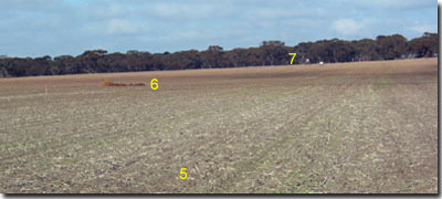 Site ORZC5 Landscape |
Soil Profile Morphology:
Surface Soil
| Ap | 0-12 cm | Dark greyish brown (10YR4/2); light clay; soft surface condition with surface flake; very weak to weak consistence (moist); slightly calcareous; pH 7.9; clear change to: |
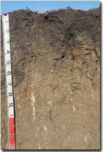 Site ORZC5 Profile |
| Subsoil | |||
| B21 | 12-20 cm | Dark grey (10YR4/1); medium clay; moderate coarse prismatic, parting to moderate coarse blocky structure; moderately calcareous; strong consistence (dry); pH 8.3; clear change to: | |
| B22 | 20-35 cm | Grey (10YR5/1); medium heavy clay; very few (2%) fine calcareous nodules; small and medium slickensides present; dark infill material down ped faces; very highly calcareous; strong consistence (dry); pH 8.7; gradual change to: | |
| B23 | 35-60 cm | Pale brown (10YR6/2); medium heavy clay; weak to moderate very coarse prismatic structure; dark infill material along ped faces; few (2-5%) fine earth carbonates and fine nodules (2 mm size); slickensides present; strong consistence (dry); pH 9.3; gradual change to: | |
| B24k | 60-100 cm | Pale brown (10YR6/3); light medium clay; some ferruginous sandstone; few (10%) fine earth carbonates (and some fine nodules); strong consistence (dry); pH 9.7; gradual change to: | |
| B25 | 100-140 cm | Pale brown (10YR6/3) with grey (10YR6/1) mottles; light medium clay; weak very coarse prismatic, parting to moderate coarse to medium polyhedral structure; few (2-5%) calcareous segregations (some fine nodules); moderately calcareous; strong consistence (dry); pH 9.7. | |
Key Profile Features:
- Soil profile cracks when dry.
- Clay texture throughout soil profile.
- Vertic properties (i.e. slickensides).
pH | Salinity Rating | |||
Surface (Ap horizon) | Slightly Alkaline | Low | Non-Sodic | None1 |
Upper subsoil (12-20 cm) | Moderately Alkaline | Low | Non-Sodic | None |
Deeper subsoil (at 35-60 cm) | Very Strongly Alkaline | Low | Strongly Sodic | Strong |
Deeper subsoil (at 100-140 cm) | Extremely Alkaline | Low | Strongly Sodic | Strong |
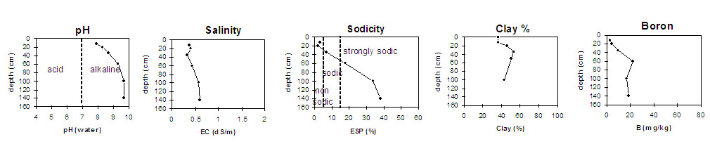 |
Horizon | Horizon Depth (cm) | pH (water) | pH (CaCl2) | EC 1:5 | NaCl % | Boron mg/kg | Exchangeable Cations | Field Capacity pF 2.5 | Wilting Point pF 4.2 | Coarse Sand (0.2-2 mm) | Fine Sand (0.02-0.2 mm) | Silt (0.002-0.02 mm) | Clay (<0.002 mm) | |||
Ca | Mg | K | Na | |||||||||||||
meq/100g | ||||||||||||||||
Ap | 0-12 | 7.9 | 7.5 | 0.37 | <0.01 | 2.7 | 23 | 4.0 | 1.9 | 0.7 | 31 | 17 | 20 | 25 | 13 | 37 |
B21 | 12-20 | 8.3 | 7.9 | 0.41 | <0.01 | 4.5 | 27 | 8.2 | 1.0 | 0.7 | 38 | 21 | 17 | 18 | 9 | 46 |
B22 | 20-35 | 8.7 | 8.1 | 0.34 | <0.01 | 9.7 | 19 | 14 | 1.1 | 2.3 | 45 | 26 | 14 | 15 | 9 | 53 |
B23 | 35-60 | 9.3 | 8.5 | 0.44 | <0.01 | 22 | 11 | 18 | 1.5 | 6.7 | 53 | 27 | 13 | 14 | 10 | 51 |
B24k | 60-100 | 9.7 | 8.8 | 0.58 | <0.01 | 17 | 5.9 | 12 | 1.2 | 9.6 | 49 | 21 | 21 | 21 | 5 | 44 |
B25 | 100-140 | 9.7 | 8.9 | 0.61 | <0.01 | 19 | 4.6 | 9.6 | 1.1 | 9.1 | ||||||
Management Considerations:
Whole Profile
- In general, management strategies for all soils should aim to increase organic matter levels in the surface soil, minimise the degradation of soil aggregates and porosity, promote the development of stable biopores, improve the calcium status of the ion exchange complex (particularly when sodium is a significant part) and break up any hardpans. Less frequent tillage, using less aggressive implements and working the soil at optimum moisture conditions can all assist in maintaining soil aggregation and porosity, as well as, reducing the breakdown of organic matter.
- The surface soil is well suited as a seedbed – the surface condition is soft and the soil has a weak consistence (i.e. it does not become excessively hard). However, it is quite shallow and should be protected as much as possible from wind and water erosion, and over-cultivation. Promoting organic matter levels would be beneficial.
- Tillage of clayey soils like these should be avoided if the soil is wet (i.e. wetter than the plastic limit). At such moisture conditions, excessive tillage, trafficking or over-stocking could result in some structural damage (e.g. compaction). Ideally, tillage should take place on clayey soils when the soil is drier than the plastic limit – down to at least the tillage depth.
- Some dispersion was noted in the field after the soil was remoulded which indicates that some structural degradation (e.g. surface sealing, crusting, increased cloddiness) may occur if the soil is cultivated or overstocked in a moist to wet condition. Also, raindrop impact on bare surface soil may also promote dispersion and result in surface sealing. Surface cover should be maintained to protect the soil against raindrop action. Management practices such as minimum tillage, stubble retention and pasture rotation can be used to improve organic matter levels.
- The upper subsoil is non-sodic (with a Ca:Mg ratio of >1) and does not disperse. This will provide conditions that will not significantly restrict root and water movement into the upper subsoil. Most roots in the soil profile were observed within 35 cm of the soil surface.
- From 35 cm depth, the subsoil becomes strongly sodic (with a Ca:Mg <1) and strongly dispersive which will restrict root and water movement into the deeper subsoil.
- The subsoil is mainly strongly alkaline. This indicates that phosphorus and some trace elements such as iron, manganese, zinc and copper may be poorly available to plants and deficiencies may occur. Deficiencies can be determined by plant tissue analysis. Boron toxicity can also occur in strongly alkaline soils. Levels of boron measured in this pit site increase in the very strongly alkaline deeper subsoil (from 35 cm depth) to levels that may affect boron sensitive species. These include cereals, pulses and pasture legumes. Boron concentrations as low as 10 ppm, for example, can reduce lentil yield. Although there is limited data it is estimated that the threshold level of soluble boron for cereals is 15 mg/kg (Cartwright et al., 1984). Other work at VIDA indicates that where there are low levels of soluble salts boron tolerance can be comparatively high, with little reduction in wheat yield at levels of up to 45 ppm (Quinlan, 2001),
References:
Cartwright, B., Zarcinas, B.A, and Mayfield, A.H. (1984). Toxic concentrations of boron in a red-brown earth at Gladstone, South Australia. Australian Journal of Soil Research. 22. 261-72.
Hobson, K. (2001). Boron Tolerant Lentils. In On The Pulse pamphlet. NRE. 2001.
Quinlan, J. (2001). Sorting out the Boron Problem. Wimmera Farming & Landcare Newsletter. 19-20.
Rengasamy, P. and Churchman, G.J. (1999). Cation Exchange Capacity, Exchangeable Cations and Sodicity. In: Soil Analysis – An Interpretation Manual. (eds. Peverill, K.I et al). CSIRO Publishing.