Victorian Resources Online (archived)
Vertosols
Vertosols are cracking clay soils that display significant shrinking and swelling during wetting and drying cycles. They exhibit strong cracking when dry, and at depth have slickensides and/or lenticular peds.
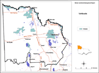
| Vertosols in the Mallee Region. This map of Vertosols in the Mallee region has been developed by Jim Rowan and is based on the Land Systems of Victoria (1:250 000). It shows areas where Vertosols are most likely to occur within the region and should only be used as a general indication of their distribution. Please note that other soil types may also occur within these mapped areas. Vertosols may occur in areas not mapped here, however, these are most likely to be minor occurrences. |
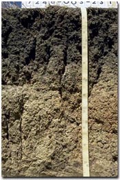 A Vertosol near Birchip. Note the large cracks in the subsoil. |
Vertosols occur on alluvium and associated lake bed deposits, along creeks and rivers as well as on broad low-lying plains in the northern Mallee.
|