Victorian Resources Online (archived)
MP14
| Location: Murrayville. | Australian Soil Classification: Hypercalcic, Subnatric, Red SODOSOL. |
| Geology: Quaternary (Woorinen Formation) deposits. | General Landscape Description: Swale between dunes. |
| Site Description: Cropping paddock (Mallee Research Station wheat variety trial site). |
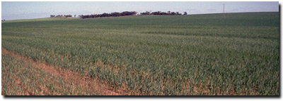 MP14 Landscape |
Soil Profile Morphology:
Surface Soil
| A1 | 0-10 cm | Dark brown (7.5YR4/4); sandy clay loam; massive, tending towards a plough pan; firm consistence dry; moderately calcareous; pH 8.7; sharp change to: | 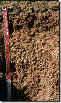 MP14 Profile |
| Subsoil | |||
| B21 | 10-25 cm | Yellowish red (5YR5/8); medium clay; moderate coarse blocky structure; strong consistence dry; moderately calcareous; pH 9.0; clear change to: | |
| B22 | 25-45 cm | Yellowish red (5YR5/8); light medium clay; moderate coarse blocky, parting to moderate medium blocky structure; very strong consistence dry; very highly calcareous; pH 9.5; clear change to: | |
| B23k | 45-75 cm | Reddish yellow (5YR6/8); light medium clay; moderate coarse prismatic, parting to strong medium blocky structure; very firm consistence dry; contains many (20-50%) soft carbonates in pockets; very highly calcareous; pH 9.6; gradual change to: | |
| B24k | 75+ cm | Reddish yellow (5YR6/6); medium heavy clay; strong coarse prismatic, parting to strong medium blocky structure (smooth-faced peds); very strong consistence dry; contains many (20-50%) soft carbonate in patches and a few (5-10%) carbonate nodules (6 cm in size); pH 9.5. | |
Key Profile Features:
- Strong texture contrast between surface (A1) horizon and subsoil (B21) horizon.
- Soil profile calcareous throughout.
- Large amount of soft calcium carbonate (lime) in deeper subsoil (i.e. hypercalcic).
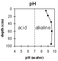 |  | |
| The surface and subsoil is strongly alkaline, becoming extremely alkaline at 45 cm depth. |
| |
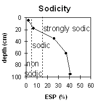 The surface soil is non-sodic. The upper subsoil is sodic and becomes strongly sodic at about 30 cm. | ||
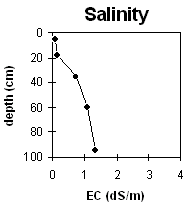
Horizon | Horizon Depth (cm) | pH (water) | pH (CaCl2) | EC 1:5 | NaCl | Total Nitrogen % | Organic Carbon % | Exchangeable Cations | |||
Ca | Mg | K | Na | ||||||||
Meq/100g | |||||||||||
A1 | 0-10 | 8.7 | 7.9 | 0.10 | <0.05 | 0.56 | 10.6 | 2.4 | 1.2 | 0.3 | |
B21 | 10-25 | 9.0 | 8.2 | 0.16 | 8.9 | 6.0 | 1.0 | 1.2 | |||
B22 | 25-45 | 9.5 | 8.8 | 0.74 | 0.10 | 5.6 | 12 | 6.6 | 6.6 | ||
B23k | 45-75 | 9.6 | 9.1 | 1.07 | 0.17 | 3.5 | 11 | 9.2 | 9.2 | ||
B24k | 75+ | 9.5 | 9.2 | 1.35 | 0.20 | 3.3 | 11 | 1.6 | 10.7 | ||
Horizon | Horizon Depth (cm) | Field Capacity pF2.5 | Wilting Point pF4.2 | Coarse Sand (0.2-2.0 mm) | Fine Sand (0.02-0.2 mm) | Silt (0.002-0.02 mm) | Clay (<0.002 mm) |
A1 | 0-10 | 17 | 9 | ||||
B21 | 10-25 | 22 | 15 | ||||
B22 | 25-45 | 41 | 28 | ||||
B23k | 45-75 | ||||||
B24k | 75+ |
Management Considerations
Whole Profile
- In general, management strategies for all soils should aim to increase organic matter levels in the surface soil; minimise the degradation of soil aggregates and porosity; promote the development of stable biopores; improve the calcium status of the ion exchange complex (particularly when sodium is a significant part – i.e. sodic), and break up any hardpans. Less frequent tillage; using less aggressive implements, and working the soil at optimum moisture conditions can all assist in maintaining soil aggregation and porosity as well as reducing the breakdown of organic matter.
- The strongly alkaline profile suggests that phosphorus and some trace elements such as iron, manganese, zinc and copper may be poorly available to plants and deficiencies may occur. Nutrient deficiencies can be assessed by plant tissue analysis. Plant species should be chosen in accordance with this pH level.
- Boron toxicity can also occur in strongly alkaline soils.
Surface (A) Horizon
- The surface soil slakes when wet and although non-sodic, disperses slightly after remoulding. This indicates that tillage or over-stocking of the soil whilst in a moist to wet condition may result in structural degradation occurring (e.g. surface sealing, increased cloddiness). There is evidence of some plough pan development at this site. Raindrop action on bare soil may have a similar effect, so it is important to maintain surface cover. The levels of organic carbon for cropping soils in the Mallee are quite low. Increasing organic matter levels will help to enhance water stable aggregation as well as improving soil fertility and water holding capacity. Gypsum application may also assist in improving surface soil structural condition by decreasing crusting on such soils.