Victorian Resources Online (archived)
MP16
| Location: Murrayville. | Australian Soil Classification: Ceteric, Petrocalcic, Lithocalcic CALCAROSOL (shallow profile depth). |
| Geology: Quaternary (Woorinen Formation) deposits. | General Landscape Description: Swale. |
| Site Description: Wheat cropping paddock (Mallee Research Station barley cropping trial). | |
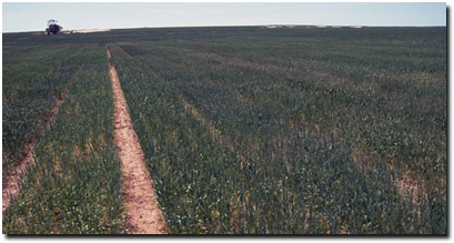 Site MP16 Landscape |
Soil Profile Morphology:
Surface Soil
| A1 | 0-10 cm | Dark brown (7.5YR4/4); sandy loam; soft surface condition overlain with calcrete gravel (less than 2 cm in size); weakly structured; firm consistence dry; moderately calcareous; pH 8.7; clear change to: | 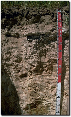 Site MP16 Profile |
| A2k | 10-25 cm | Brown (7.5YR5/4); sandy clay loam; massive in structure; firm consistence dry; many (20-50%) carbonate nodules in 20-25 cm zone; very highly calcareous; pH 8.9; sharp change to: | |
| Subsoil | |||
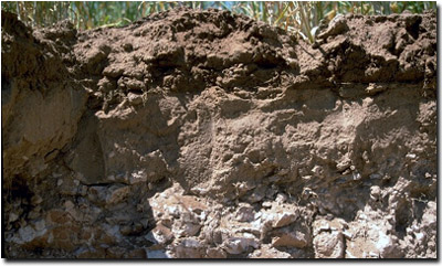
| C | 25-60 cm | Calcrete layer. | |
| Dk | 60-120 cm | Mainly carbonate gravel and soft carbonate, with pockets of reddish yellow (7.5YR6/6); sandy clay loam; gradual change to: | |
| D1 | 120+ cm | Light yellowish brown (10YR6/4) with red (2.5YR5/8) mottles; heavy clay (sandy); strong consistence dry; very few (2%) dark (manganese) flecks in patches; slightly calcareous; pH 10.1. | |
Site MP16 Profile
Key Profile Features:
- Strongly alkaline throughout.
- Shallow soil profile overlying calcrete layer.
- Calcrete layer at 25-60 cm depth.
 |
 | |
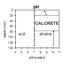
The surface soil is strongly alkaline and the subsoil (below calcrete layer) is extremely alkaline. |
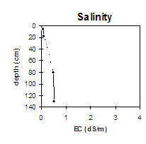
The surface soil has a low salinity rating. The subsoil (below calcrete layer) has a low to moderate salinity rating. | |
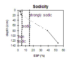 The surface soil is non-sodic. The subsoil below the calcrete layer is strongly sodic. The diagonal dotted line shows where the layer of calcrete lies within the soil profile. | ||
Horizon | Horizon Depth (cm) | pH (water) | pH (CaCl2) | EC 1:5 | NaCl | Total Nitrogen % | Organic Carbon % | Exchangeable Cations | |||
Ca | Mg | K | Na | ||||||||
Meq/100g | |||||||||||
A1 | 0-10 | 8.7 | 7.9 | 0.09 | <0.05 | 0.47 | 6.2 | 1.0 | 1.0 | 0.2 | |
A2k | 10-25 | 8.9 | 8.1 | 0.11 | 7.6 | 1.8 | 0.9 | 0.4 | |||
D1 | 120+ | 10.1 | 8.8 | 0.55 | <0.05 | 1.4 | 3.4 | 1.5 | 3.9 | ||
Horizon | Horizon Depth (cm) | Field Capacity pF2.5 | Wilting Point pF4.2 | Coarse Sand (0.2- 2.0 mm) | Fine Sand (0.02- 0.2 mm) | Silt (0.002- 0.02 mm) | Clay (<0.002 mm) |
A1 | 0-10 | 9 | 3 | ||||
A2k | 10-25 | ||||||
D1 | 120+ | 23 | 11 |
Management Considerations
Whole Profile
- In general, management strategies for all soils should aim to increase organic matter levels in the surface soil; minimise the degradation of soil aggregates and porosity; promote the development of stable biopores; improve the calcium status of the ion exchange complex (particularly when sodium is a significant part – i.e. sodic), and break up any hardpans. Less frequent tillage; using less aggressive implements, and working the soil at optimum moisture conditions can all assist in maintaining soil aggregation and porosity as well as reducing the breakdown of organic matter.
- Plant available water capacity (PAWC) for the profile will be quite low due to the shallow profile depth.
- The soil profile will be well drained. Water is also likely to readily move down the fractured calcrete layer.
- The strongly alkaline profile suggests that phosphorus and some trace elements such as iron, manganese, zinc and copper may be poorly available to plants and deficiencies may occur. Nutrient deficiencies can be assessed by plant tissue analysis. Plant species should be chosen in accordance with this pH level.
- Boron toxicity can occur in strongly alkaline soils.
- The sandy surface will have rapid water infiltration, slowing down at the less permeable sub-surface and calcrete substrate.
- The low wilting point value (3%) indicates that plants will be able to utilise light rains during dry periods. However, due to this soils low water storage capacity, plants will suffer moisture stress unless further rains occur. Increasing the low levels of organic matter will assist in enhancing soil water holding capacity as well as fertility and aggregation.
- The calcrete layer is likely to restrict root and water movement to some degree, however, water and roots are likely to penetrate this layer more easily in comparison to sodic clay subsoils in the region.
- The calcrete layer will not supply adequate nutrients required for plant growth.
- The subsoil below the calcrete layer is very gravelly and calcareous and has a very low inherent fertility, extremely high alkalinity and is strongly sodic. These factors make the layer fairly inhospitable for plant growth.
- The surface layer (A1) contains boron while the subsurface horizon (A2) has double this amount of boron.