Victorian Resources Online (archived)
MP47
| Location: Murrayville Landcare Group. | Australian Soil Classification: Endohypersodic, Pedal, Hypercalcic, CALCAROSOL. |
| Geology: Quaternary (Woorinen Formation) deposits. | General Landscape Description: Flat plain. |
| Site Description: Grazing paddock. |
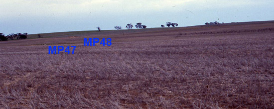
MP47 Landscape
Soil Profile Morphology:
Surface Soil
| A11 | 0-10 cm | Dark greyish brown (7.5YR3/4); sandy clay loam; weak to firm consistence (dry); slightly calcareous; pH 8.3; clear change to: |
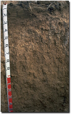 MP47 Profile |
| A12 | 10-20 cm | Darkish greyish brown (7.5YR4/4); sandy clay loam (heavy); firm consistence (moist); moderately calcareous; pH 8.5; clear change to: | |
| Subsoil | |||
| B1 | 20-30 cm | Darkish greyish brown (7.5YR4/4); light clay; strong medium blocky structure; firm to very firm consistence (moist); highly calcareous; pH 9.0; clear change to: | |
| B21k | 30-60 cm | Greyish brown (7.5YR5/4), with light greyish brown (10RY7/2) mottles; light medium clay; strong coarse prismatic, parting to strong coarse to medium blocky structure; strong consistence (dry); many (20%) fine-earth carbonates; highly calcareous; pH 9.8; gradual change to: | |
| B22 | 60-100 cm | Brown (7.5YR5/6); medium heavy clay; strong coarse prismatic parting to strong coarse to medium blocky structure; strong consistence (dry); few (5%) fine-earth carbonates; highly calcareous; pH 9.8; change to: | |
| B23 | 100+ cm | Reddish brown (5YR5/6); strong very coarse prismatic, parting to strong fine to medium blocky structure; strong consistence (moist); contains few (2%) fine-earth carbonates; moderately calcareous; pH 9.5. | |
Key Profile Features:
- Gradual increase in texture with depth down the soil profile.
- Soil profile is calcareous throughout.
pH | Salinity Rating | |||
Surface (A1 horizon) | Moderately alkaline | low | Non-sodic | None |
Subsoil (B21 horizon) | Extremely alkaline | low-medium | Strongly sodic | Mod-strong |
Deeper subsoil (at 1 m) | Very strongly alkaline | Very high | Strongly sodic | strong |
 |  |
| The soil profile becomes increasingly alkaline with depth. | The level of soluble salts increases with depth down the profile. |
 |  |
| The soil profile becomes increasingly sodic with depth. | The clay content increases gradually with depth down the profile. |
Horizon | Horizon Depth (cm) | pH (water) | pH (CaCl2) | EC 1:5 | NaCl | Total Nitrogen % | Organic Carbon % | Exchangeable Cations | |||
Ca | Mg | K | Na | ||||||||
Meq/100g | |||||||||||
A11 | 0-10 | 8.3 | 7.8 | 0.15 | - | 0.1 | 2.9 | 20 | 2.5 | 1.7 | 0.13 |
A12 | 10-20 | 8.5 | 7.9 | 0.14 | - | - | - | 22 | 3.1 | 1.1 | 0.18 |
B1 | 20-30 | 9 | 8.2 | 0.22 | - | - | - | 27 | 8.6 | 1.2 | 1.4 |
B21k | 30-60 | 9.8 | 8.7 | 0.57 | 0.03 | - | - | 7.5 | 11 | 1.1 | 3.6 |
B22 | 60-100 | 9.8 | 9.1 | 1.2 | 0.15 | - | - | 5.5 | 9.2 | 1.4 | 7.6 |
B23 | 100+ | 9.5 | 9.1 | 1.5 | 0.21 | - | - | - | - | - | - |
Horizon | Horizon Depth (cm) | Exchangeable Aluminium mg/kg | Field Capacity pF2.5 | Wilting Point pF4.2 | Coarse Sand (0.2- 2.0 mm) | Fine Sand (0.02-0.2 mm) | Silt (0.002-0.02 mm) | Clay (<0.002 mm) |
A11 | 0-10 | - | 16 | 6.7 | 34 | 44 | 5 | 15 |
A12 | 10-20 | - | 16.5 | 7.4 | 32 | 42 | 4 | 19 |
B1 | 20-30 | - | 27.2 | 13.6 | 23 | 31 | 10 | 23 |
B21k | 30-60 | <5 | 35.3 | 18.5 | 22 | 23 | 5 | 33 |
B22 | 60-100 | <5 | 41.7 | 20.7 | 21 | 23 | 6 | 43 |
B23 | 100+ | - | - | - | - | - | - | - |
Management Considerations:
Whole Profile
- Much of the soil profile is extremely alkaline. This suggests that some nutrients (e.g. manganese, zinc, iron, copper) may be poorly available to plants.
Surface (A) Horizons
- The surface soil has a relatively high nutrient holding capacity compared to many other soils in the area. This is due to the relatively higher clay and organic matter contents.
Subsoil (B) Horizons
- The subsoil is sodic and dispersive. Root and water movement into the subsoil will be restricted as a result. It is important to avoid cultivating this soil whilst in a moist to wet condition as some structural degradation could occur.
- The high level of soluble salts in the deeper subsoil may restrict the growth of deeper- rooted salt sensitive species.
Profile Described By: Mark Imhof (August 1999).