Victorian Resources Online (archived)
MP31
| Location: Speed. | Australian Soil Classification: Supracalcic, Mesonatric, Red SODOSOL (very thick sandy surface). |
| Geology: Quaternary Woorinen Formation overlying Tertiary Parilla Sandstone. | |
| General Landscape Description: Upper slope of a north-south stranded beach ridge. | |
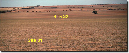 Site MP31 and MP32 Landscape |
Soil Profile Morphology:
Surface Soil
| Ap | 0-22 cm | Brown (7.5YR5/4); sand; loose surface condition and slightly water repellent; structureless (single grain); very weak consistence dry; pH 6.7; sharp and wavy change to: |  Site MP31 Profile |
| Ap | 22-25 cm | Reddish yellow (7.5YR7/6) discontinuous conspicuous bleach; sand; structureless (single grain); loose consistence dry; sharp and smooth change to: | |
| A12 | 25-30 cm | Brown (7.5YR4/4); sand; structureless (single grain); very weak consistence dry; pH 7.1; abrupt and wavy change to: | |
| A21 | 30-65 cm | Reddish yellow (7.5YR6/8); sand; structureless (single grain); very weak consistence dry; pH 7.8; abrupt and wavy change to: | |
| A22 | 65-70 cm | Reddish yellow (7.5YR6/6); sand; structureless (single grain); loose consistence moist; pH 8.6; sharp and wavy change to: | |
Subsoil | |||
| B1 | 70-85 cm | Reddish yellow (5YR5/8); sandy loam; massive; firm consistence dry; pH 9.5; wavy and gradual change to: | |
| B21 | 85-105 cm | Reddish yellow (5YR5/8); sandy clay loam (clayey) patches; weakly structured; very firm consistence moist; contains few (2-5%) fine-earth carbonates in patches; pH 9.6; wavy and gradual change to: | |
| C | 105+ cm | Sand with very many fine-earth carbonates and hard carbonate nodules in bands. With greater depth the carbonate reduces and the profile becomes a reddish yellow clayey sand; pH 10.1. | |
Key Profile Features:
- Deep sandy surface horizons.
- Increase in clay in subsoil which is massive to weakly structured.
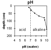 | 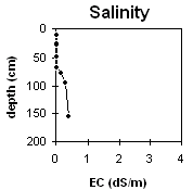 |
The surface horizon is slightly acid. The rest of the surface soil becomes more alkaline with depth. The subsoil is very strongly alkaline, becoming extremely alkaline at 1m. | The salinity rating is very low for the surface horizons and marginally increases with depth in the subsoil. |
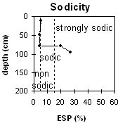 | 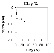 |
The surface horizons are non-sodic. The subsoil is strongly sodic. | The clay content increases in the subsoil horizons. |
Whole Profile
- In general, management strategies for all soils should aim to: increase organic matter levels in the surface soil, minimise the degradation of soil aggregates and porosity, promote the development of stable biopores, break up any hardpans, and improve the calcium status of the ion exchange complex. Particularly when sodium plays a significant part i.e. the soil is sodic. Less frequent tillage, using less aggressive implements, and working the soil at optimum moisture conditions can all assist in maintaining soil aggregation and porosity, as well as reducing the breakdown of organic matter. Farming practices on cropping soils such as residue retention, minimum tillage and pasture rotations could be utilised to build up organic matter, reduce erosion risk and increase the soils low inherent fertility.
- The sandy surface horizons have a very low plant available water capacity and low inherent fertility. This surface soil also displays a degree of water repellence that may restrict water infiltration. Otherwise water infiltration should be high through the sandy horizons. The low wilting point value for the surface soil indicates that plants will be able to readily utilise light rains, as opposed to heavier textured surface horizons. However, these soils can become ‘droughty’ if further rainfalls do not eventuate.
- The strongly alkaline subsoil suggests that some nutrients (e.g. manganese, zinc, iron, copper) may be poorly available to plants. Boron toxicity can also occur in strongly alkaline soils.
- The coarsely structured subsoil is strongly sodic and has a low exchangeable calcium to magnesium ratio (ie. 0.8). Dispersion occurs as a result, restricting root and water movement in the deeper subsoil.
Profile Described By: Mark Imhof, Paul Rampant and Sonia Thompson (17/4/95).