Victorian Resources Online (archived)
WCSS10
| Location: Speed | Plot: Speed Field Day site |
| Aust. Soil Class.: Hypercalcic, Effervescent, Red SOSOSOL | |
| General Landscape Description: Dune and swale | Site Description: Speed Field Days site |
| Geology: Quaternary aeolian deposits | |
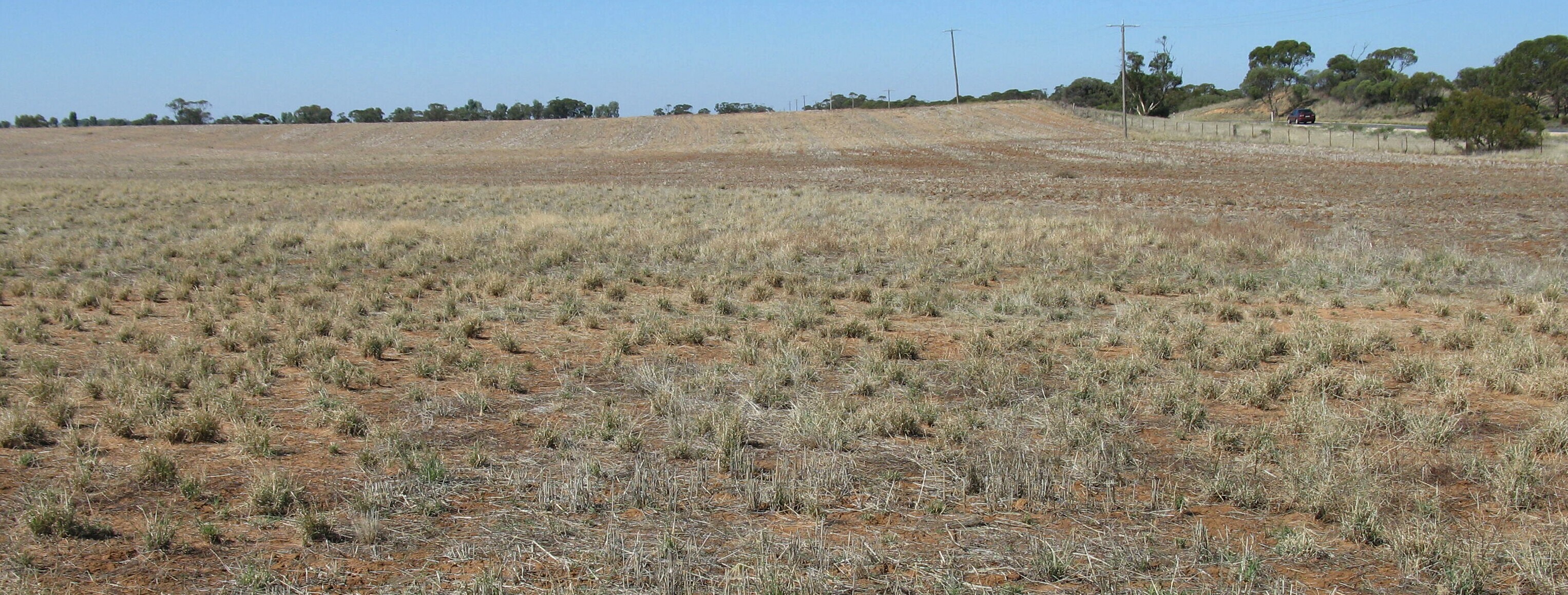 WCSS10 Landscape |
Soil Profile Morphology:
Surface Soil
| A1 | 0-12 cm | Brown (7.5YR4/4); loamy sand; weak platey structure; loose consistence (dry); soft surface condition; slightly clacareous; pH 7.8; sharp change to: | 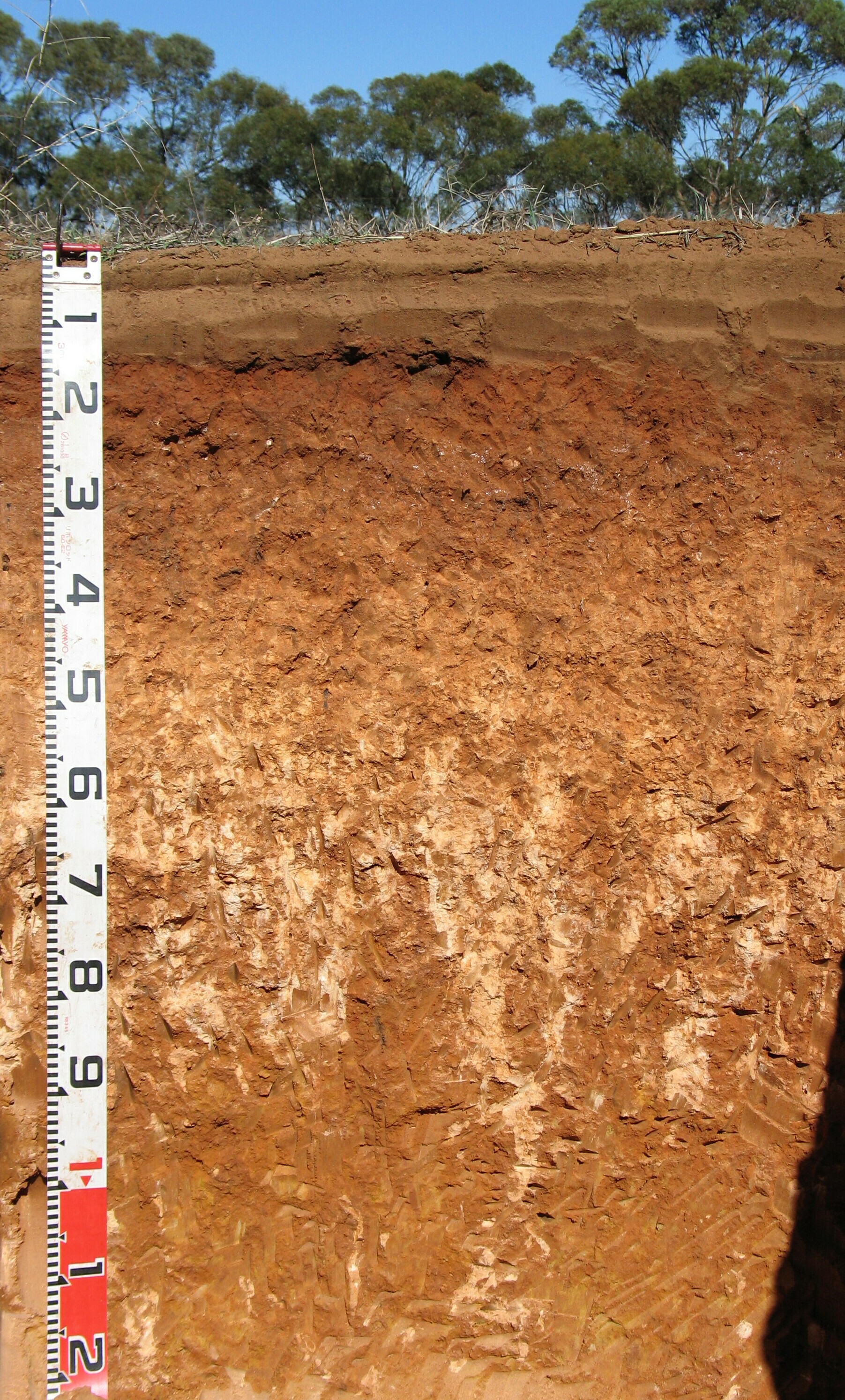 WCSS10 Profile |
| Subsoil | |||
| B21 | 12-20 (30) cm | Red (2.5YR4/8); medium clay (coarse sandy); strong coarse angular blocky, parting to coarse subangular blocky structure; very firm consistence (moderately moist); slightly calcareous; pH 8.4; clear change to: | |
| B22k | 20(30)-50 cm | Red (2.5YR5/8); light medium clay; strong coarse angular blocky, parting to moderate medium subangular blocky structure; strong consistence (dry); soft extremely coarse calcareous segregations common; highly calcareous; pH 9.4; gradual change to: | |
| B23k | 50-90 cm | Yellowish red (5YR5/8); medium clay; moderate strong to medium subangular blocky structure; very firm (dry) consistence; many soft calcareous segregations with a few calcareous nodules; very highly calcareous; pH 9.9; gradual change to: | |
| B24 | 90-130 cm | Yellowish red (5YR5/8) with many medium distinct reddish yellow mottles (7.5YR6/8); medium clay (coarse sandy); moderate strong to medium subangular blocky structure; strong (dry) consistence; few soft calcareous segregations; slightly calcareous; pH 9.9. | |
Key Profile Features:
- Strong texture contrast between surface (A) horizon and subsoil (B21) horizon
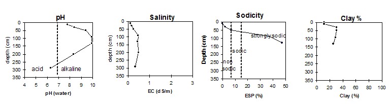
pH | Salinity Rating | |||
Surface (A1 horizon) | Slightly alkaline | Very low | Sodic | |
Subsoil (B21 horizon ) | Moderately alkaline | Very low | Strongly sodic | |
Deeper subsoil (90-130 cm) | Extremely alkaline | Low-Medium | sodic |
- 1 Due to high levels of soluble salts.
 |
Horizon | Horizon Depth | pH (water) | pH CaCl2 | EC 1:5 | Org. Carbon mg/kg | Exchangeable Cations | |||
Ca | Mg | K | Na | ||||||
Meq/100g | |||||||||
A1 | 0-12 | 7.8 | 7.2 | 0.1 | 0.91 | 5.8 | 1.6 | 0.06 | 0.06 |
B21 | 12-20(30) | 8.4 | 7.8 | 0.17 | 0.42 | 19 | 6.2 | 0.5 | 0.5 |
B22k | 20(30)-50 | 9.4 | 8.5 | 0.25 | 19 | 9.4 | 2.2 | 2.2 | |
B23k | 50-90 | 9.9 | 8.9 | 0.46 | 1.2 | 6.6 | 0.96 | 5.2 | |
B24 | 90-130+ | 9.9 | 9.0 | 0.44 | 0.71 | 5.4 | 0.83 | 6.1 | |
200 | 8.3 | 7.5 | 0.48 | ||||||
290 | 6.3 | 5.8 | 0.33 | ||||||
Horizon | Horizon Depth | Boron mg/kg | ESP % | Field pF 2.5 | Wilting Point pF 4.2 | Coarse Sand (0.2-2.0mm) % | Fine Sand (0.02-0.2mm) % | Silt (0.002-0.02mm) % | Clay (<0.002mm) % |
A1 | 0-12 | 0.7 | <1 | 8.7 | 3.9 | 51 | 34 | 1 | 11 |
B21 | 12-20(30) | 1.7 | 2 | 24.4 | 11.7 | 35 | 25 | 6 | 30 |
B22k | 20(30)-50 | 9.2 | 7 | 30.2 | 15.4 | 25 | 18 | 1 | 30 |
B23k | 50-90 | 19 | 37 | 30.6 | 13.4 | 29 | 29 | 3 | 29 |
B24 | 90-130+ | 14 | 47 | 29.6 | 11.3 | 34 | 36 | 2 | 25 |
200 | 3.3 | ||||||||
290 | 2 |