Victorian Resources Online (archived)
MP38b
Location: WalpeupAustralian Soil Classification: Sodic, Hypercalcic, Red CHROMOSOL (medium sandy surface)
General Landscape Description: Swale between east-west dune.
Geology: Quaternary (Woorinen Formation) deposits.
Land Use: Cropping.
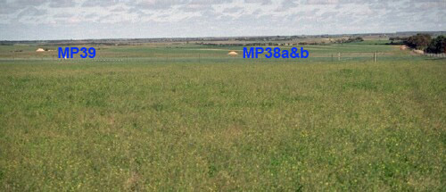 MP38 and MP39 landscape |
Soil Profile Morphology:
Surface Soil
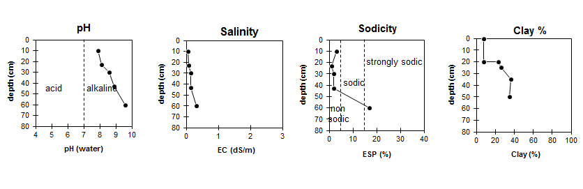
| A1 | 0-20 cm | Strong brown (7.5YR4/6); loamy sand; very weak consistence dry; non calcareous; pH 7.9: | 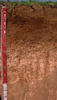 MP38b profile |
| Subsoil | |||
| B1 | 20-25 cm | Dark brown (7.5YR3/4); sandy clay loam; weak coarse blocky structure; weak consistence moist; non calcareous; pH 8.1: | |
| B21 | 25-35 cm | Yellowish red (5YR5/6) with some yellowish red (5YR4/6); medium clay (sandy); weak coarse blocky structure; weak consistence moist; moderately calcareous; pH 8.6: | |
| B22k | 35-50 cm | Reddish yellow (5YR6/8); light medium clay; weak consistence moist; contains a common (20%) amount of soft and hard carbonate; very strongly calcareous; pH 8.9: | |
| B23k | 50-100 cm | Yellowish red (5YR5/8); light clay becoming clay loam with depth; weak polyhedral structure; firm consistence moist; contains a few (2-5%) hard carbonates (5-10 mm in size) and very many (>50%) soft carbonates; very strongly calcareous; pH 9.6: |
Key Profile Features:
- Texture contrast between sandy surface (A) horizon and subsoil (B21) horizon.
- Large amount of soft carbonate in deeper subsoil.
Soil Profile Characteristics:
| |||||||||||||||||||||||||||||||||||||||||||||||||||||||||||||||||||||||||||||||||||||||||||||||||||||||||||||||||||||||||||||||||||||||
Profile Described By: Mark Imhof and Nathalie Baxter (September 1996).