Victorian Resources Online (archived)
Archived content — This page contains material from the Victorian Resources Online (VRO) website. It is no longer maintained and is provided for reference only. This content is hosted by CeRDI and is not endorsed by Agriculture Victoria.
Sitemap
Elevation
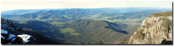
View from Mount Buffalo. |
Mount Bogong (1 986 m above sea level) is the highest peak in the Victorian alpine region. It is surrounded by several other peaks above 1 500 m, including Mt Feathertop (1 922 m), Mt Hotham (1 862 m) and Mt Buffalo (1 723 m). Just south of Mt Bogong are the Bogong High Plains and further south again lie the Dargo High Plains and Snowy Range. The highest peaks all rest in the southern part of the region. As elevation declines, gradually hill slopes develop. Moving further north towards the Murray River eventually the landscape grades into undulating plains. There are, however, exceptions to this trend, where Mt Burrowa (1 278 m) is accompanied by Mt Mitta Mitta (1 001 m) and Pine Mountain in the northern most section of the region, east of Lake Hume (Duncan, 1982).

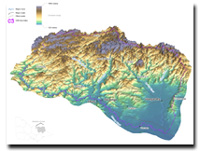
North East Elevation |
The Digital Elevation Model map is intended to provide a broad indication of the approximate elevation of land resources throughout the region. Elevation is an indicator to be used with other mapped data (such as geomorphic units and landform) to visually display landform within this region.
This Elevation map provides a broad-scale overview of the relief across the region. The Digital Elevation Model (DEM) was derived from 1:25 000 topographic data, including contours, spot heights, hydrology (stream enforced) and shore boundaries using ANUDEM software. The interpolation of topographic data is to a 20 m x 20 m grid, which has been resampled to 100 m cell size for display on this website.
|