Victorian Resources Online (archived)
Local Government
|
The following Local Government Authorities have offices in the North East Catchment Management region
|  Offices of the Wangaratta Shire |
The following Local Government Authorities do not have offices in the North East region, but their boundaries intersect those of the CMAs
- Shire of East Gippsland (external link)
- Shire of Wellington (external link)
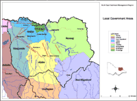 North East Local Government Areas | The Local Government Areas (LGAs) map shows the relative areas and boundaries of each Local Government Area located within the region. Data for this map is derived from the Local Government Area layer (L100) of the Department of Primary Industries Corporate Geospatial Data Library. This layer describes the post amalgamation LGA boundaries as defined by the Department of Finance. Place names (ie. towns) are provided by Vicroads and AUSLIG. |