Victorian Resources Online (archived)
NE16
| Group: Springhurst- Byawatha Hills Landcare Group | Australian Soil Classification: Bleached-Mottled, Mesotrophic, Red KUROSOL (thick, moderately gravelly, sandy/clayey) |
| Northcote Factual Key: Dr 3.41 | Great Soil Group: red podzolic |
| General Landscape Description: Upper slope (9% slope) of a granite hillslope. This site also contains Permian fluvioglacial deposits. Original vegetation included Red Box (Eucalyptus polyanthemos) and Red Gum (E. blakleyii). | |
Site Description:
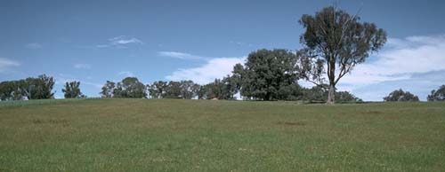 NE16 landscape |
Soil Profile Morphology:
Surface Soil
A11 | 0-5 cm | Brown (7.5YR4/4); loamy sand; structureless; firm consistence dry; contains many (40%) quartz gravels (4mm average size); pH 5.5; abrupt change to: | 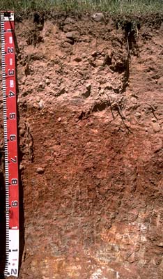 NE16 profile |
A12 | 5-20 cm | Brown (7.5YR4/4); sandy loam; firm consistence dry; contains many (40%) quartz gravels (4mm average size); pH 5.3; abrupt change to: | |
A2 | 20-40 cm | Yellowish red (5YR5/6) conspicuously bleached (5YR7/4d); sandy loam; very firm consistence dry; contains very many (50%) quartz gravels (4mm average size) as well as rounded pebbles of glacial origin; pH 5.3; abrupt and wavy change to: | |
| Subsoil | |||
| B21 | 40-70 cm | Dark red (2.5YR4/8); medium clay; moderate medium blocky, breaking down to moderate fine blocky structure (shiny faced peds); very firm consistence dry; contains many (40%) quartz gravels (4mm average size) as well as rounded pebbles of glacial origin; pH 5.5; gradual change to: | |
| B22 | 70-90 cm | Dark red (2.5YR3/6) with brownish yellow (10YR6/6) mottles; medium clay; strong medium blocky, breaking down to strong fine blocky structure (shiny faced peds); strong consistence dry; contains many (40%) quartz gravels (5mm average size); pH 5.5; abrupt and wavy change to: | |
| B3 | 90-110 cm | Light grey (10YR7/2) with dark red (2.5YR3/6) mottles; medium heavy clay; very firm consistence moist; contains weathered granite; pH 4.8: | |
| C | 110 cm+ | Weathered granite. | |
Key Profile Features:
- Strong texture contrast between surface horizons (<13% clay) and top of subsoil (65% clay).
- High (> 40%) gravel content throughout the soil profile.
Soil Profile Characteristics:
Horizon | pH | Salinity Rating | ||
Surface (A1 horizon) | strongly acid | very low | non-sodic | none |
Subsoil (B21 horizon) | strongly acid | very low | non-sodic | none |
Deeper subsoil (at 1 m) | very strongly acid | very low | non-sodic | none |
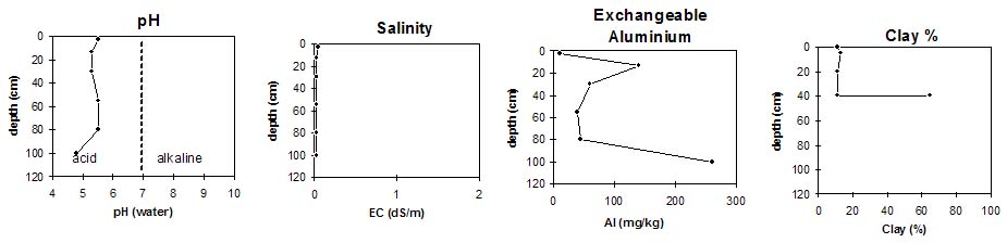
Horizon | Horizon Depth (cm) | pH (water) | pH (CaCl2) | EC 1:5 | Exchangeable Cations | |||
Ca | Mg | K | Na | |||||
meq/100g | ||||||||
A11 | 0-5 | 5.5 | 4.7 | 0.05 | 5.8 | 1.1 | 0.6 | <0.1 |
A12 | 5-20 | 5.3 | 4.4 | <0.05 | 2.1 | 0.7 | 0.6 | <0.1 |
A2 | 20-40 | 5.3 | 4.4 | <0.05 | 0.9 | 0.5 | 0.3 | <0.1 |
B21 | 40-70 | 5.5 | 4.7 | <0.05 | 2.7 | 3.5 | 1.1 | <0.1 |
B22 | 70-90 | 5.5 | 4.6 | <0.05 | 1.0 | 4.9 | 0.7 | 0.1 |
B/C | 90-110 | 4.8 | 3.9 | <0.05 | 0.2 | 8.5 | 0.7 | 0.3 |
Horizon | Horizon Depth (cm) | Exchangeable Aluminium mg/kg | Field Capacity pF 2.5 | Wilting Point pF 4.2 | Coarse Sand (0.2-2.0 mm) | Fine Sand (0.02-0.2 mm) | Silt (0.002-0.02 mm) | Clay (<0.002 mm) |
A11 | 0-5 | 10 | 18.7 | 9.7 | 32 | 40 | 10 | 11 |
A12 | 5-20 | 140 | 17.1 | 6.8 | 33 | 37 | 14 | 13 |
A2 | 20-40 | 60 | 12.9 | 4 | 34 | 41 | 16 | 11 |
B21 | 40-70 | 39 | 25.7 | 17.8 | 10 | 18 | 9 | 65 |
B22 | 70-90 | 44 | ||||||
B/C | 90-110 | 260 |
Management Considerations:
Whole Profile
- Plant available water capacity (PAWC) is considered to be relatively low (estimated at approximately 80 mm). This is based on available laboratory data and assumes an effective rooting depth of 90 cm. Rooting depth will be restricted in the magnesic and very strongly acid B3 horizon.
Surface (A) Horizons
- The surface (A1) horizon is strongly acid which indicates that aluminium and manganese toxicity may occur. The level of exchangeable aluminium as measured in the laboratory is, however, quite low for this horizon. This could be due to the effect of organic matter.
- The pH decreases at 5 cm (A12 horizon). Exchangeable aluminium levels have increased significantly in this horizon to a level (140 mg/kg) which is likely to restrict the growth of aluminium sensitive species (eg. barley, lucerne, phalaris, canola and some medic and wheat varieties). Ideally a pH/aluminium test should be done on a bulk sample taken across the paddock. At 20 cm depth (A2 horizon), exchangeable aluminium levels have decreased. There should be likely long term benefits of applying lime (preferably incorporated) at this site if the test results are representative of the paddock. Other factors need to be considered, however, before lime would be recommended (eg. pasture species grown; method of application; whether cropping will take place; local trial responses; soil surface structure; likely cost/benefits).
- Deficiencies in molybdenum, phosphorus and potassium may occur in the strongly acid surface horizons. If lime is required, an application may assist in alleviating any molybdenum deficiency and increase phosphorus availability.
- The high gravel content in the surface horizons are likely to interfere with cultivation, and prove abrasive to implements.
Subsoil (B) Horizons
- The upper subsoil is strongly acid. Levels of exchangeable aluminium are not high. The deeper subsoil (from 90cm depth) is, however, very strongly acid and exchangeable aluminium levels are very high (260 mg/kg). These levels are only likely to restrict the growth of deeper rooted aluminium sensitive species.
- The cation exchange is dominated by magnesium in the subsoil. This could result in a cation imbalance (eg. potassium and/or calcium deficiency). The high level of exchangeable magnesium in relation to calcium may also contribute to poor subsoil structure.