Victorian Resources Online (archived)
NE17
| Group: Springhurst-Byawatha Hills Landcare Group | Australian Soil Classification: Bleached, Eutrophic, Red KUROSOL (thick, sandy/clay loamy) |
| Northcote Factual Key: Dr 2.81 | Great Soil Group: red podzolic |
| General Landscape Description: Crest (slope <2%) of a granite hill. Original vegetation included Blakely’s Red Gum (Eucalyptus blakelyi). | |
Site Description:
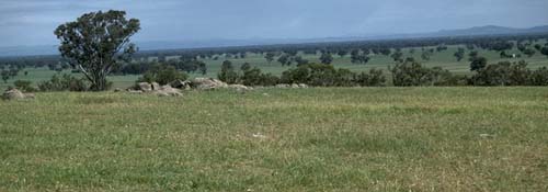 NE17 landscape |
Soil Profile Morphology:
Surface Soil
A1 | 0-10 cm | Brown (10YR4/3); loamy sand; hardsetting surface condition; structureless; firm consistence dry; contains a few (5%) quartz gravels (4mm average size); pH 5.6; abrupt change to: | 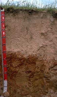 NE17 profile |
A2 | 10-60 cm | Yellowish red (5YR5/6) conspicuously bleached (5YR7/3d); loamy sand; structureless; weak consistence dry; contains a common (15%) amount of quartz gravel (4mm average size); pH 5.5; abrupt change to: | |
| Subsoil | |||
B2 | 60-90 cm | Dark red (2.5YR4/8) and red (2.5YR5/8); light sandy clay loam; weakly structured (some shiny faced peds evident); very firm consistence moderately moist; pH 5.3; sharp and tongued change to: | |
B3 | 90-120 cm | Brownish yellow (10YR6/6); sand (with pockets of light sandy clay loam); structureless; firm consistence dry: | |
C | 120 cm+ | Weathered granite. | |
Key Profile Features:
- Moderate texture contrast between surface (A) horizons (6% clay) and subsoil (B21) horizon (21% clay)
Soil Profile Characteristics:
Horizon | pH | Salinity Rating | ||
Surface (A1 horizon) | moderately acid | very low | non-sodic | none |
Subsoil (B21 horizon) | strongly acid | very low | non-sodic | none |
Deeper subsoil (at 1 m) | stronglyly acid | very low | non-sodic | none |
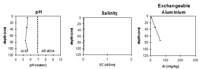
Horizon | Horizon Depth (cm) | pH (water) | pH (CaCl2) | EC 1:5 | Exchangeable Cations | |||
Ca | Mg | K | Na | |||||
meq/100g | ||||||||
A1 | 0-10 | 5.6 | 4.9 | <0.05 | 4.5 | 1.3 | 0.6 | <0.1 |
A2 | 10-60 | 5.5 | 4.5 | <0.05 | 0.5 | 0.1 | 0.3 | <0.1 |
B2 | 60-90 | 5.3 | 4.5 | <0.05 | 1.8 | 1.9 | 0.4 | <0.1 |
B3 | 90-120 | 5.6 | 4.7 | <0.05 | 0.9 | 1.5 | 0.2 | <0.1 |
Horizon | Horizon Depth (cm) | Exchangeable Aluminium mg/kg | Field Capacity pF 2.5 | Wilting Point pF 4.2 | Coarse Sand (0.2-2.0 mm) | Fine Sand (0.02-0.2 mm) | Silt (0.002-0.02 mm) | Clay (<0.002 mm) |
A1 | 0-10 | <10 | 14.5 | 8.2 | 39 | 41 | 9 | 6 |
A2 | 10-60 | 31 | 10.4 | 2.3 | ||||
B2 | 60-90 | 65 | 16 | 6.7 | 43 | 27 | 10 | 21 |
B3 | 90-120 |
Management Considerations:
Whole Profile
- Plant available water capacity (PAWC) is considered to be low to very low (estimated at approximately 50 mm). This is based on available laboratory data and assumes an effective rooting depth of 85 cm (depth to which roots were evident in the soil pit).
- The soil profile will be well drained due to the high coarse sand and quartz gravel content throughout the profile.
Surface (A) Horizons
- The surface (A1) horizon has a high coarse sand (39%) and fine sand (41%) content. Organic matter is vital for maintaining aggregation on such soils. These soils are susceptible to wind erosion if surface cover is reduced.
- The surface soil has a low water holding capacity. Such soils will become ‘droughty’ in periods of low rainfall. The low wilting point value (8%), however, indicates that plants will be able to utilise light rains falling on relatively dry soil.
- The surface soil is moderately acid and exchangeable aluminium levels measured for the bulked paddock sample around this site are not high (42 mg/kg) but may affect highly aluminium sensitive species.
- The phosphorus level (Olsen method) measured for the bulked paddock sample is low to moderate for a lightly stocked paddock. The State Chemistry Laboratory (SCL) recommends that this part of the paddock be sown with 12-13 kg/hectare of actual phosphorus. In the following year topdressing should occur at the same rate. The rate of phosphorus application could be increased by 2-3 kg/ha in the early years of pasture establishment.
- The level of potassium measured in the bulked paddock sample is relatively low at this site. SCL suggests that a test strip of 125 kg/hectare muriate of potash be considered before introducing potassium into the fertiliser program.
- The sulphur level measured in the bulked sample is low. SCL recommends assessing sulphur responses on the paddock by applying a gypsum (calcium sulphate) test strip (at 200-300 kg/ha) in early spring. On light textured surface soils such as these, consider applying at least some of the sulphur in the elemental form (rather than the sulphate form) as it is less prone to leaching. Elemental sulphur is also an acidifying fertiliser and should be used with caution.
- The deep subsurface (A2) horizon has a very low inherent fertility (based on the sum of the exchangeable cations) and does not provide favourable conditions for plant growth. Although strongly acid, the exchangeable aluminium level is not high (31 mg/kg) for the pit site sample.
Subsoil (B) Horizons
- The upper subsoil is only weakly structured which will restrict root growth to some extent. It is strongly acid and has a moderate level (65 mg/kg) of exchangeable aluminium which may restrict the growth of highly aluminium sensitive species (eg. lucerne and phalaris).