Victorian Resources Online (archived)
NE31
| Group: Tallangatta Valley Landcare Group | Australian Soil Classification: Acidic, Dystrophic, Red DERMOSOL |
| Northcote Factual Key: Gn | Great Soil Group: red podzolic |
| General Landscape Description: Midslope of a low hill (slope 12%) on Ordovician sediments. | |
| Site Description: | |
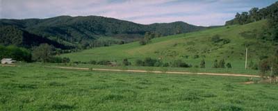 NE31 landscape |
Soil Profile Morphology:
Surface Soil
O | 0-2 cm | Organic mat: | 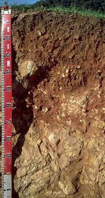 NE31 profile |
A1 | 2-12 cm | Dark brown (7.5YR3/4); fine sandy clay loam; firm consistence dry; contains many (25%) colluvial gravel (6 mm average diameter); pH 4.8; clear change to: | |
| Subsoil | |||
B1 | 12-25 cm | Yellowish red (5YR5/8); clay loam (fine sandy); moderate medium blocky structure; pH 5.0; clear change to: | |
B21 | 25-40 cm | Red (2.5YR5/8); light clay (fine sandy); moderate medium blocky, breaking down to weak fine blocky structure; pH 4.9. | |
B/C | 40-70 cm | Dark red (2.5YR4/8); light fine sandy clay loam ; moderate medium blocky, breaking down to weak fine blocky structure; pH 5.5: | |
C | 70+ cm | Base rock. Depth to bedrock varies across the pit from 25 cm to 1 metre depth. | |
Key Profile Features:
- Lack of clear texture change between surface (A) and subsoil (B21) horizon.
- Shallow soil profile.
Soil Profile Characteristics:
Horizon | pH | Salinity Rating | ||
Surface (A1 horizon) | very strongly acid | very low | non-sodic | none |
Subsoil (B21 horizon) | strongly acid | very low | non-sodic | none |
Deeper subsoil (at 60 cm) | moderately acid | very low | non-sodic | none |
Horizon | Horizon Depth (cm) | pH (water) | pH (CaCl2) | EC 1:5 | Exchangeable Cations | |||
Ca | Mg | K | Na | |||||
meq/100g | ||||||||
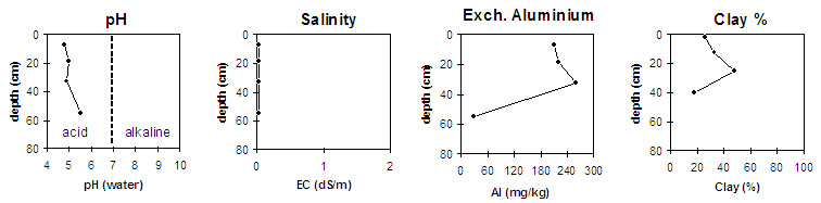
A1 | 2-12 | 4.8 | 4.1 | <0.05 | 2.3 | 0.3 | 0.2 | <0.1 |
B21 | 12-25 | 5.0 | 4.2 | <0.05 | 0.7 | 0.2 | 0.1 | <0.1 |
B22 | 25-40 | 4.9 | 4.2 | <0.05 | 1 | 0.3 | 0.3 | <0.1 |
B/C | 40-70 | 5.5 | 4.7 | <0.05 | 7.2 | 1.5 | 0.2 | <0.1 |
Horizon | Horizon Depth (cm) | Exchangeable Aluminium mg/kg | Field Capacity pF 2.5 | Wilting Point pF 4.2 | Coarse Sand (0.2-2.0 mm) | Fine Sand (0.02-0.2 mm) | Silt (0.002-0.02 mm) | Clay (<0.002 mm) |
A1 | 2-12 | 210 | 30.6 | 11.6 | 14 | 30 | 23 | 26 |
B21 | 12-25 | 220 | 28.2 | 10.9 | 10 | 33 | 23 | 33 |
B22 | 25-40 | 260 | 23.7 | 14.5 | 10 | 25 | 18 | 48 |
B/C | 40-70 | 30 | 33.7 | 12.4 | 12 | 38 | 23 | 18 |
Management Considerations:
Whole Profile
- Plant available water capacity (PAWC) is considered to be low (estimated at 60 mm) for this site. This is based on available laboratory data and assumes an effective rooting depth of 70 cm. Rooting depth will be restricted by the baserock.
- The soil profile will be relatively well drained. Subsoil drainage will be good as water will easily penetrate the fractured and well weathered fine-textured bedrock.
Surface (A) Horizon
- In the strongly acid surface horizon, the level of exchangeable aluminium measured in the laboratory (210 mg/kg) is high enough to restrict the growth of a range of aluminium sensitive species (eg. lucerne, phalaris, some clovers, tall fescue). A pH/aluminium test on a bulked sample taken across the paddock will give a better guide as to how much lime is needed to raise pH. Increasing soil pH will assist in reducing the level of aluminium toxicity. Other factors, however, need to be considered before lime is recommended (eg. pasture species grown, method of application, local trial responses, soil surface structure and likely cost/benefit).
- The surface soil has a low inherent nutrient status (based on the sum of the exchangeable basic cations). Organic carbon and total nitrogen levels are relatively high. Organic matter is important on surface soils such as these (with high fine sand and silt contents) for maintaining surface soil stability. Low levels of organic matter will promote slaking and subsequent aggregate breakdown, leading to exacerbated surface sealing and hardsetting.
Subsoil (B) Horizons
- Levels of exchangeable aluminium remain high in the upper subsoil. Surface lime application will have negligible benefit to subsoil acidity.
- Inherent fertility is very low in the upper subsoil horizons (based on the exchangeable basic cations).
Notes
Profile described by Mark Imhof, Paul Rampant and Karen De Plater (25/10/95).