Victorian Resources Online (archived)
Site NE38
Property: Rutherglen Research Institute.
Paddock #: F
Australian Soil Classification: Bleached-Sodic, Eutrophic, Red CHROMOSOL
Northcote Factual Key: Dy 3.43
Great Soil Group: No suitable group.
General Landscape Description: Higher area of plain.
Soil Mapping Unit: Type A.
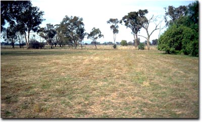 Site NE38 Landscape |
Soil Profile Morphology:
Surface Soil
| A1 | 0-12 cm | Brown (7.5YR4/4); light fine sandy clay loam; weak coarse blocky structure; weak consistence moist; pH 5.4; clear change to: | 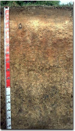 Site NE38 Profile |
| A2 | 12-30 cm | Pinkish brown (7.5YR6.5/4) conspicuously bleached (7.5YR8/2d); light fine sandy clay loam; structureless; firm consistence dry; pH 6.0; clear change to: | |
| Subsoil | |||
| B21 | 30-55 cm | Yellowish red (5YR5/8); light medium clay; weak medium polyhedral, parting to weak fine polyhedral structure; strong consistence dry; manganese stains occur in patches; pH 6.8; gradual change to: | |
| B22 | 55-80 cm | Brownish yellow (10YR6/6) with dark red (2.5YR4/6) mottles; light medium clay; moderate medium polyhedral, parting to fine polyhedral structure; strong consistence dry; pH 6.0; clear change to: | |
| B23 | 80-100 cm | Pale yellow (2.5Y7/4) [with yellowish red (5YR5/8) colours associated with root channels]; light medium clay; weakly structured; strong consistence dry; pH 6.8; clear change to: | |
| B24 | 100-140 cm | Very pale brown (10YR7/3) with brownish yellow (10YR6/8) mottles; light medium clay; moderate coarse polyhedral structure; strong consistence dry; contains many (30%) manganese stains along ped faces and very few nodules (up to 1 cm size); pH 7.0; clear change to: | |
| B3 | 140 cm+ | Light brownish grey (10YR6/2) with yellowish red (5YR5/8) mottles; light medium clay; strong coarse prismatic, breaking to strong coarse blocky structure; strong consistence dry; pH 8.0. | |
Key Profile Features:
- Strong texture contrast between surface (A) horizons (15% clay) and subsoil (B21) horizon (38% clay).
- Conspicuously bleached subsurface (A2) horizon.
Soil Profile Characteristics:
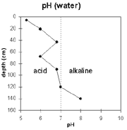 | The surface horizon is strongly acid. The upper subsoil is mainly slightly acid. The deeper subsoil is alkaline. | 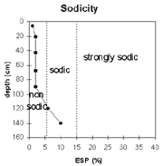 | The top metre of the soil profile is non-sodic. The deeper subsoil is sodic and dispersive. Note: prismatic structure occurs below 140 cm depth. |
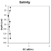 | The level of soluble salts is very low throughout the soil profile. | 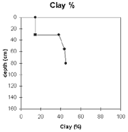 | The clay % increases sharply at the A/B horizon interface. |
Horizon | Horizon Depth (cm) | pH (water) | pH (CaCl2) | EC 1:5 | Exchangeable Cations | Exchangeable Aluminium mg/kg | Field Capacity pF 2.5 | Wilting Point pF 4.2 | Coarse Sand (0.2 - 2 mm) | Fine Sand (0.02 -0.2 mm) | Silt (0.002 -0.02 mm) | Clay (<0.002 mm) | |||
Ca | Mg | K | Na | ||||||||||||
meq/100g | |||||||||||||||
A1 | 0-12 | 5.3 | 4.4 | 0.11 | 2.9 | 0.56 | 1.5 | <0.05 | 10 | 28 | 7 | 2 | 53 | 22 | 15 |
A2 | 12-30 | 6 | 5.3 | 0.09 | 2.6 | 0.69 | 0.64 | <0.05 | 20 | 5 | 2 | 54 | 29 | 15 | |
B21 | 30-55 | 6.8 | 5.6 | <0.05 | 3.1 | 2.1 | 2.2 | 0.09 | 25 | 13 | 1 | 37 | 25 | 38 | |
B22 | 55-80 | 6 | 5.1 | 0.08 | 3.2 | 2.2 | 2.7 | 0.14 | 29 | 13 | 2 | 33 | 23 | 44 | |
B23 | 80-100 | 6.8 | 5.9 | 0.06 | 3.1 | 2.1 | 1.5 | 0.14 | |||||||
B24 | 100-140 | 7 | 6.1 | 0.09 | 3.9 | 4.8 | 0.9 | 0.56 | |||||||
B3 | 140+ | 8 | 6.8 | 0.11 | 6.9 | 9.9 | 0.74 | 1.8 | |||||||
Management Considerations:
Whole Profile
- Plant available water capacity (PAWC) is considered to be low (estimated at 85 mm) for the top metre of the soil profile. This is based on available laboratory data.
- Exchangeable potassium levels are relatively high throughout the soil profile. According to Baker and Eldershaw (1993) levels of exchangeable potassium (relative to Cation Exchange Capacity) above 10% can result in magnesium deficiency.
- Although the surface horizons are non-sodic, slight dispersion occurs after remoulding. This indicates that some structural degradation may occur if the soil is cultivated in a moist-wet condition.
- The surface horizon has high fine sand (53%) and silt (22%) content. Organic matter is therefore important for maintaining soil aggregation and preventing slaking. The soil is likely to become 'powdery' when cultivated dry, which may result in surface sealing occurring.
- The surface soil has a low nutrient status (based on the sum of the exchangeable basic cations).
- The upper subsoil is non-sodic but disperses completely after remoulding. Deep tillage should therefore be avoided if the soil is in a moist to wet condition.
- Upper subsoil drainage should be reasonable due to the non-sodic conditions. Water movement will be restricted to some degree at the A/B horizon interface due to the reasonably large increase in clay content.
- The subsoil has a low-medium nutrient status (based on the sum of the exchangeable basic cations).
- The large amount of manganese segregations in the deep subsoil may restrict the growth of deep rooted manganese sensitive plants.
- Deep profile drainage will be restricted by the sodic and strongly dispersive deeper subsoil.
- Pasture since 1969.
- Sown to Trikkala clover in 1990.
References:
Baker, D.E. and Eldershaw, V.J. (1993). Interpreting Soil Analysis for Agricultural Land Use in Queensland. Project Report Series. Queensland, Department of Primary Industries.