Victorian Resources Online (archived)
Site NE40
Property: Rutherglen Research Institute.
Paddock Number: 30
Australian Soil Classification: Haplic, Eutrophic, Red CHROMOSOL (gravelly surface).
Northcote Factual Key: Dr 2.42
Great Soil Group: No suitable group.
General Landscape Description: Ordovician sediments within the upper slope of a hill at 3% slope.
Soil Mapping Unit: Type H.
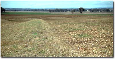 Site NE40 Landscape |
Soil Profile Morphology:
Surface Soil
| A1 | 0-15 cm | Dark reddish brown (5YR3/3); sandy clay loam; weak consistence moist; contains many (50%) quartz gravel fragments (4-40 mm size); pH 5.5; abrupt change to: | 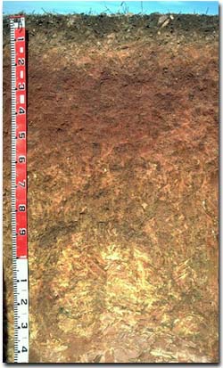 Site NE40 Profile |
| A2 | 15-20 cm | Yellowish red (5YR4/8); fine sandy clay loam; discontinuous; contains an abundant (70%) amount of quartz gravel (4-50 mm size); abrupt change to: | |
| Subsoil | |||
| B21 | 20-45 cm | Red (10R4/8); medium heavy clay; strong coarse blocky, parting to strong fine polyhedral structure; firm consistence moderately moist; contains a trace (< 2%) amount of quartz gravel (2 - 5 mm size); pH 6.2; gradual change to: | |
| B22 | 45-70 cm | Dark red (2.5YR4/8) with strong brown (7.5YR5/8) mottles; medium clay; strong coarse blocky, parting to strong fine polyhedral structure; very firm consistence, moderately moist; contains a few (2%) quartz gravel fragments (5-20 mm size); pH 6.9: | |
| B23 | 70-100 cm | Dark red (10R3/6) with yellowish brown (10YR5/8) mottles; medium clay; moderate very coarse prismatic, parting to moderate coarse blocky structure; very firm consistence moderately moist; contains a few (2%) quartz gravel fragments; pH 7.3: | |
| B3 | 100-130 cm | Yellow (10YR7/6) with dark red (2.5YR4/8) mottles; light clay; moderate coarse prismatic, parting to moderate coarse blocky to fine blocky structure; firm consistence, moderately moist; contains many (50%) weathered rock fragments; pH 7.7: | |
| C | 130 cm+ | Mudstone. |
Key Profile Features:
- Strong texture contrast between surface (A) horizons (18% clay) and subsoil (B21) horizon (82 % clay).
- Gravelly surface horizons.
Soil Profile Characteristics:
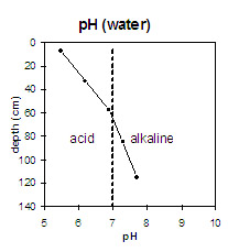 | The surface horizons are strongly acid. The upper subsoil is slightly acid and the deeper subsoil is slightly alkaline. | 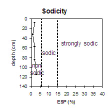 | The soil profile is non-sodic throughout. |
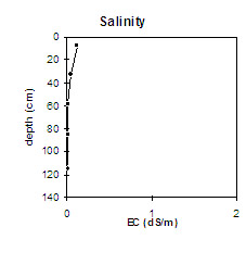 | The salinity rating is very low throughout. | 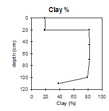 | There is a significant increase in clay percentage at the A/B horizon interface. |
Horizon | Horizon Depth (cm) | pH (water) | pH (CaCl2) | EC 1:5 | Exchangeable Cations | Exchangeable Aluminium mg/kg | Field Capacity pF 2.5 | Wilting Point pF 4.2 | Coarse Sand (0.2 - 2.0 mm) | Fine Sand (0.02 -0.2 mm) | Silt (0.002 -0.02 mm) | Clay (<0.002 mm) | |||
Ca | Mg | K | Na | ||||||||||||
meq/100g | |||||||||||||||
A1 | 0-15 | 5.5 | 4.8 | 0.12 | 4.5 | 1 | 0.98 | 0.12 | 10 | 26 | 10 | 13 | 47 | 15 | 19 |
B21 | 20-45 | 6.2 | 5.4 | 0.05 | 7.2 | 2.8 | 1.2 | 0.1 | 37 | 23 | 3 | 11 | 5 | 82 | |
B22 | 45-70 | 6.9 | 6.1 | <0.05 | 6.9 | 4.6 | 0.75 | 0.14 | 34 | 23 | 4 | 8 | 7 | 83 | |
B23 | 70-100 | 7.3 | 6.4 | <0.05 | 5.3 | 5.6 | 0.52 | 0.19 | 33 | 20 | 4 | 13 | 12 | 72 | |
B3 | 100-130 | 7.7 | 6.6 | <0.05 | 3.1 | 5.5 | 0.24 | 0.23 | 33 | 13 | 7 | 24 | 35 | 37 | |
Management Considerations:
Whole Profile
- Plant available water capacity (PAWC) is considered to be medium (estimated at 110 mm) for the top metre of the soil profile. This is based on available laboratory data. Most roots were evident in the top 50 cm of the profile which has an estimated PAWC of approximately 50 mm.
- Surface (A) Horizons
The level of exchangeable aluminium is low (10 mg/kg) in the strongly acid surface soil. These levels are not likely to affect plant rowth. However, a pH/aluminium test on a bulked sample (taken from across the paddock) would be most appropriate to determine if lime is needed to raise soil pH.
- The large amount of coarse gravel will be abrasive to farm implements.
- The subsoil is non-sodic and strongly structured (parting to many fine polyhedral shaped peds). This will provide suitable conditions for root and water movement. The reddish colour and lack of mottling in the upper subsoil indicates that drainage and aeration is good.
- The subsoil has a moderate nutrient status based on the sum of the exchangeable basic cations.
- Disc ploughed in 1986 and cultivated in 1987.
- Cultivated old winegrape area in 1984.
- Experimental pea plots planted in 1994.
- Sub clover sown in 1986.