Victorian Resources Online (archived)
Site NE44
Property: Rutherglen Research Institute.
Paddock Number: 31
Australian Soil Classification: Haplic, Eutrophic, Red CHROMOSOL (slightly gravelly) / Vertic Yellow Sodosol
Northcote Factual Key: Dr 2.23
Great Soil Group: no suitable group.
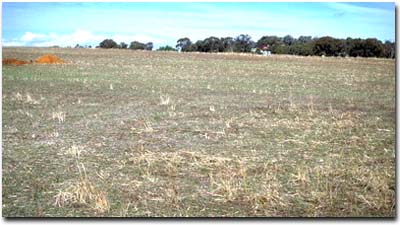
General Landscape Description: Lower midslope (3% slope) of hill, composed of Ordovician sediments.
Soil Mapping Unit: Type G.
 Site NE44 Landscape |
Soil Profile Morphology:
Surface Soil
| A1 | 0-10 cm | Dark brown (7.5YR3/4); fine sandy clay loam; hardsetting; weak coarse blocky, parting to weak medium blocky structure; firm consistence dry; pH 6.1; clear change to: | 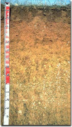 Site NE44 Profile |
| A2 | 10-20 cm | Yellow red (5YR4/6); fine sandy clay loam; structureless; strong consistence dry; pH 5.2; abrupt change to: | |
| Subsoil | |||
| B21 | 20-40 cm | Dark red (2.5YR4/8); medium clay; moderate coarse polyhedral, parting to moderate medium polyhedral strucure; very firm consistence dry; contains a few (2%) ferruginous nodules (2-5 mm size) and a common (10%) amount of quartz gravel (2-5 mm size); pH 6.0; clear change to: | |
| B22 | 40-60 cm | Strong brown (7.5YR5/8) with red (2.5YR4/6) mottles; light medium clay; moderate coarse polyhedral, parting to moderate medium polyhedral structure; very firm consistence dry; contains a few (2%) ferruginous nodules (2-5 mm size); pH 7.0; gradual change to: | |
| B23 | 60-90 cm | Yellowish brown (10YR5/8) with dark red (2.5YR4/6) mottles; medium clay; strong medium polyhedral, parting to moderate fine polyhedral structure; very firm consistence dry; pH 7.5; clear and wavy change to: | |
| B24 | 90-120 cm | Yellowish brown (10YR5/8) with dark red (2.5YR4.8) mottles; light medium clay; moderate medium polyhedral structure; strong consistence dry; contains manganese stains and very many (60%) quartz gravel fragments (2-20 mm size range); pH 7.8; clear wavy change to: | |
| B25 | 120-160 cm | Brownish yellow (10YR6/8) with dusky red (7.5R2.5/4) mottles; light medium clay; very firm consistence moist; contains many (20%) ferruginous nodules (6 mm size); gradual and wavy change to: | |
| 2B2b | 160 cm+ | Light olive brown (2.5Y6/4) with yellowish red (5YR5/8) mottles; medium heavy clay; strong consistence dry; slickensides; strong dispersion; pH 8.5. | |
Key Profile Features:
- Strong texture contrast between surface (A) horizons (< 30% clay) and subsoil (B21) horizon (52% clay).
- The deep subsoil from 160 cm depth, is part of an older Quaternary land surface. There is a characteristic lighter colour, strong prismatic structure (associated with strongly sodic conditions) and strong slickenside development (indicating different clay mineralogy).
Soil Profile Characteristics:
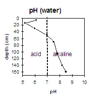 | The surface soil is slightly acid whereas the subsurface (A2) horizon is strongly acid. The upper subsoil is moderately acid and pH increases with depth. The deeper subsoil is moderately alkaline. | 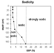 | The top metre of the soil profile is non-sodic. The deeper subsoil is sodic and the deep subsoil (from 160cm) is strongly sodic and dispersive. |
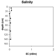 | The level of soluble salts is very low throughout the soil profile. | 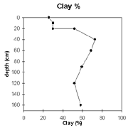 | The clay % increases significantly at the A/B horizon interface. |
Horizon | Horizon Depth (cm) | pH (water) | pH (CaCl2) | EC 1:5 | Exchangeable Cations | Exchangeable Aluminium mg/kg | Field Capacity pF 2.5 | Wilting Point pF 4.2 | Course Sand (0.2 - 2.0 mm) | Fine Sand (0.02 -0.2 mm) | Silt (0.002 -0.02 mm) | Clay (<0.002 mm) | |||
Ca | Mg | K | Na | ||||||||||||
meq/100g | |||||||||||||||
A1 | 0-10 | 6.1 | 5.3 | 0.08 | 4.6 | 1.1 | 1.3 | 0.12 | 25 | 10 | 10 | 47 | 16 | 26 | |
A2 | 10-20 | 5.2 | 4.4 | 0.1 | 3.4 | 0.82 | 0.96 | 0.08 | 33 | 25 | 9 | 10 | 46 | 12 | 30 |
B21 | 20-40 | 6 | 5.1 | <0.05 | 5 | 1.7 | 0.73 | 0.11 | 27 | 14 | 10 | 30 | 6 | 52 | |
B22 | 40-60 | 7 | 6.1 | 0.05 | 6.8 | 3.5 | 0.55 | 0.2 | 37 | 21 | 4 | 16 | 6 | 73 | |
B23 | 60-90 | 7.5 | 6.6 | 0.05 | 6.6 | 4.5 | 0.57 | 0.28 | 34 | 19 | 5 | 16 | 9 | 69 | |
B24 | 90-120 | 7.8 | 6.7 | 0.05 | 6.1 | 5.4 | 0.55 | 0.4 | 29 | 18 | 7 | 22 | 13 | 60 | |
B25 | 120-160 | 8.2 | 6.6 | 0.06 | 4.8 | 7.1 | 0.46 | 1.5 | 28 | 18 | 18 | 22 | 10 | 52 | |
B3 | 160+ | 8.5 | 7 | 0.08 | 7.5 | 12 | 0.45 | 3.5 | 43 | 22 | 5 | 21 | 12 | 59 | |
Management Considerations:
Whole Profile
- Plant available water capacity (PAWC) is considered to be medium (estimated at 115 mm) for the top metre of the soil profile. This is based on available laboratory data.
- The surface (A1) horizon has a very high fine sand and silt content (ie. 63 %). Organic matter is therefore important for maintaining aggregation and preventing slaking. Practices which increase soil organic matter (e.g. minimum tillage, stubble retention, pasture rotations, direct drilling) should be adopted.
- The surface (A1) horizon is only slightly acid (compared to a strongly acid A2 horizon) which reflects recent lime applications. The strongly acid subsurface (A2) horizon indicates that aluminium and manganese toxicity may occur. However, the level of exchangeable aluminium measured in the laboratory (33 mg/kg) is not high and unlikely to restrict plant growth. This is best assessed from samples taken across the paddock.
- The upper subsoil is reasonably structured (parting to medium sized polyhedral shaped peds), non-sodic and non-dispersive. Root and water movement in the upper subsoil is not likely to be significantly restricted as a result.
- The nutrient status of the subsoil (based on the sum of the exchangeable basic cations) is low-moderate.
- The deep subsoil is sodic and dispersive which will result in restricted water movement at depth.
- Cultivated in 1977 and disc cultivated in 1994.
- Lime applied at 1 cwt/acre (100 pounds/acre) in 1983 and at 1 t/ha in 1994.
- Lupins grown .
- Clover sown in 1995.