Victorian Resources Online (archived)
NE19
| Location: Tallangatta Valley Landcare Group. | Australian Soil Classification: Haplic, Mesotrophic, Red DERMOSOL |
| Northcote Factual Key: Gn 3.11 | Great Soil Group: red podzolic. |
| General Landscape Description: Lower terrace of the Tallangatta Creek. | |
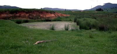 Site NE19 Landscape |
Soil Profile Morphology:
Surface Soil
| A11 | 0-10 cm | Dark yellowish brown (10YR3/4); fine sandy clay loam; weakly structured; very firm consistence dry; contains a common (10%) amount of quartz fragments (4 mm average diameter); pH 5.5; clear change to: | 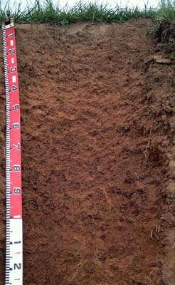 Site NE19 Profile |
| A12 | 10-25 cm | Reddish brown (5YR4/4); fine sandy clay loam; weak medium polyhedral structure; firm consistence dry; contains a common (10%) amount of quartz fragments (4 mm average diameter); pH 5.6; clear change to: | |
| Subsoil | |||
| B21 | 25-60 cm | Yellowish red (5YR4/6); light clay (fine sandy); moderate medium blocky, parting to moderate fine polyhedral structure; firm consistence dry; contains a few (5%) quartz fragments (4 mm average diameter); pH 6.0; gradual change to: | |
| B22 | 60-110 cm | Dark red (2.5YR4/6); medium clay; strong medium polyhedral parting to strong fine polyhedral structure; very firm consistence dry; contains a few (5%) amount of quartz fragments (4 mm average diameter); gradual change to: | |
| B23 | 110-130 cm | Yellowish red (5YR5/7); clay loam (fine sandy); moderate medium polyhedral, parting to moderate fine polyhedral structure; strong consistence dry; contains a common (15%) amount of quartz fragments (4 mm average diameter) as well as few (5%) alluvial materials (8 mm diameter); contains few (10%) soft manganese segregations; pH 5.8; abrupt change to: | |
| B3 | 130-180 cm | Cemented layer; abrupt change to: | |
| C | 180+ cm | Cemented coarse river gravels. | |
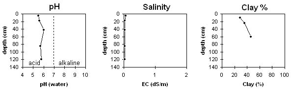
Key Profile Features:
- Gradual increase in clay content with depth, measured down to one metre.
Soil Profile Characteristics:
Horizon | pH | Salinity Rating | ||
Surface (A1 horizon) | strongly acid | very low | non-sodic | none |
Subsoil (B21 horizon) | moderately acid | very low | non-sodic | none |
Deeper subsoil (at 1 m) | moderately acid | very low | non-sodic | none |
Horizon | Horizon Depth (cm) | pH (water) | pH (CaCl2) | EC 1:5 | Exchangeable Cations | |||
Ca | Mg | K | Na | |||||
meq/100g | ||||||||
A11 | 0-10 | 5.5 | 4.5 | 0.06 | 2.0 | 0.5 | 0.8 | <0.1 |
A12 | 10-25 | 5.6 | 4.8 | <0.05 | 2.8 | 0.6 | 0.5 | <0.1 |
B21 | 25-60 | 6.0 | 5.0 | <0.05 | 3.8 | 0.9 | 0.5 | <0.1 |
B22 | 60-110 | 5.7 | 5 | <0.05 | 5.2 | 1.6 | 0.7 | 0.1 |
B23 | 110-130 | 5.8 | 5.1 | <0.05 | 4.2 | 1.6 | 0.4 | <0.1 |
Horizon | Horizon Depth (cm) | Exchangeable Aluminium mg/kg | Field Capacity pF 2.5 | Wilting Point pF 4.2 | Coarse Sand (0.2-2.0 mm) | Fine Sand (0.02-0.2 mm) | Silt (0.002-0.02 mm) | Clay (<0.002 mm) |
A11 | 0-10 | 47 | 29 | 8 | ||||
A12 | 10-25 | 8 | 39 | 27 | 29 | |||
B21 | 25-60 | 25 | 11 | 7 | 34 | 28 | 36 | |
B22 | 60-110 | 6 | 25 | 26 | 46 | |||
B23 | 110-130 |
Management Considerations:
Whole Profile
- Plant available water capacity (PAWC) is considered to be medium - high (estimated at 145 mm) for this site. This is based on available laboratory data and assumes an effective rooting depth of 130 cm. Rooting depth will be limited by the cemented horizon (B3) in the lower subsoil.
- The level of exchangeable aluminium measured in the strongly acid surface horizon is high enough (47 mg/kg) to possibly restrict the growth of highly aluminium sensitive species such as lucerne, phalaris and some medic species. Lime application would raise the pH and reduce the levels of exchangeable aluminium. However, other factors need to be considered before lime is recommended e.g. pasture species grown, method of application, local trial responses, soil surface structure and likely cost/benefits. Also, a pH/aluminium test should be carried out on a bulked paddock sample, to determine the application rate required.
- The level of exchangeable potassium is quite high (24%) in the surface horizon and remains at about 10 % throughout most of the profile. Such high levels may result in magnesium deficiency (Baker and Eldershaw, 1993).
- The inherent fertility of the surface horizons is low (based on the sum of the exchangeable basic cations).
- The surface soils have a high fine sand and silt content. Organic matter is important for maintaining aggregation on these soils. If cropping takes place then organic matter levels will decline. These levels should be built up again using green manure crops and pasture rotations.
- The pH increases slightly in the subsoil and aluminium levels will be negligible.
- The subsoil has a moderate inherent fertility (based on the sum of the exchangeable basic cations). Exchangeable calcium is relatively high in relation to exchangeable magnesium which will assist in maintaining good subsoil structure. The subsoils are relatively well structured and well drained, and provide good plant rooting conditions.
References:
Baker, D.E. and Eldershaw, V.J. (1993). Interpreting Soil Analysis for Agricultural Land Use in Queensland. Project Report Series. Queensland, Department of Primary Industries.