Victorian Resources Online (archived)
NE20
| Location: Tallangatta Valley Landcare Group. | Australian Soil Classification: Epihypersodic, Epipedal, Aquic (Brown) VERTOSOL |
| Northcote Factual Key: Ug 5.35 | Great Soil Group: brown clay. |
| General Landscape Description: Low level flood plain on the lower reaches of the Tallangatta Creek valley. | |
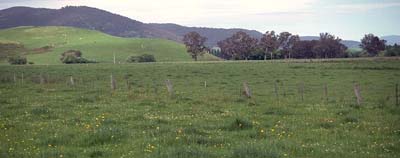 Site NE20 Landscape |
Soil Profile Morphology:
Surface Soil
| A1 | 0-10 cm | Very dark brown (10YR2/2); silty clay; cracking surface condition; moderate medium blocky, breaking down to strong fine blocky structure; very firm consistence dry; pH 5.1; clear change to: | 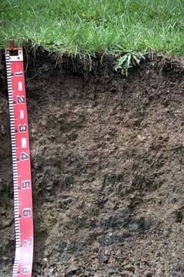 Site NE20 Profile |
| Subsoil | |||
| B21 | 10-20 cm | Dark brown (10YR3/3) mixed with brown (10YR5/3); silty clay; moderate medium blocky, parting to strong fine blocky structure; firm consistence dry; pH 5.2; abrupt change to: | |
| B22 | 20-40 cm | Brown (10YR5/3); silty clay; moderate medium blocky, parting to moderate fine blocky structure; firm consistence dry; pH 5.8; abrupt change to: | |
| B31 | 40-65 cm | Grey (10YR5/1) with yellow (10YR7/6) mottles; light medium clay (silty); moderate medium prismatic, parting to moderate medium blocky structure; slickensides present; dark root stains; pH 7.7; gradual and wavy change to: | |
| B32 | 65-80 cm | Grey (10YR5/1) with red (2.5YR5/6) mottled medium clay; dark root stains; pH 8.2; clear change to: | |
| B33 | 80-100 cm | Grey (7.5YR5/1) with reddish yellow (7.5YR6/8) mottles; medium clay (coarse sandy); very sticky consistence wet; contains a few (10%) quartz gravels (4 mm average size) and mica; pH 8.2. | |
Key Profile Features:
- High clay and silt content throughout most of the profile.
- Significant shrink-swell characteristics.
Soil Profile Characteristics:
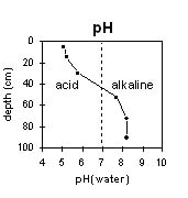
Horizon | pH | Salinity Rating | ||
Surface (A1 horizon) | strongly acid | very low | non-sodic | none |
Subsoil (B21 horizon) | strongly acid | very low | non-sodic | none |
Deeper subsoil (at 90 cm) | moderately alkaline | very low | strongly sodic | strong |
Horizon | Horizon Depth (cm) | pH (water) | pH (CaCl2) | EC 1:5 | Exchangeable Cations | |||
Ca | Mg | K | Na | |||||
meq/100g | ||||||||
A1 | 0-10 | 5.1 | 4.5 | 0.09 | 4.5 | 2.9 | 0.4 | 0.2 |
B21 | 10-20 | 5.2 | 4.4 | 0.05 | 2.4 | 2.1 | 0.4 | 0.2 |
B22 | 20-40 | 5.8 | 4.6 | 0.06 | 1.3 | 2.3 | 0.3 | 0.7 |
B31 | 40-65 | 7.7 | 5.8 | 0.12 | 2.6 | 5.5 | 0.3 | 2.7 |
B32 | 65-80 | 8.2 | 6.6 | 0.14 | 3.0 | 6.5 | 0.1 | 2.8 |
B33 | 80-100 | 8.2 | 6.8 | 0.08 | 2.1 | 4.3 | 0.1 | 1.4 |
Horizon | Horizon Depth (cm) | Exchangeable Aluminium mg/kg | Field Capacity pF 2.5 | Wilting Point pF 4.2 | Coarse Sand (0.2-2.0 mm) | Fine Sand (0.02-0.2 mm) | Silt (0.002-0.02 mm) | Clay (<0.002 mm) |
A1 | 0-10 | 86 | 52 | 24 | 1 | 14 | 36 | 36 |
B21 | 10-20 | 150 | 43 | 18 | 3 | 14 | 40 | 38 |
B22 | 20-40 | 38 | 15 | |||||
B31 | 40-65 | 1 | 12 | 47 | 43 | |||
B32 | 65-80 | |||||||
B33 | 80-100 |
Management Considerations:
Whole Profile
- Plant available water capacity (PAWC) is considered to be relatively low (estimated at 75 mm) for this soil profile. This is based on available laboratory data and assumes an effective rooting depth of 40 cm. Rooting depth is likely to be restricted by the strongly sodic and poorly drained deeper subsoil.
- The high wilting point value (24%) indicates that plants will be unable to utilise light rains falling on relatively dry soil.
- The level of exchangeable aluminium in the strongly acid surface soil is high enough to restrict the growth of highly aluminium sensitive species.
- Organic carbon and total nitrogen levels are high for this site.
- Excessive trafficking, overstocking, or cultivation should be avoided on cracking clay soils when they are moderately moist to wet. At such moisture conditions these practises can result in structural damage occurring e.g. compaction and smearing. Ideally, tillage and trafficking should take place when the soil is drier than the plastic limit down to about 20 cm depth.
- Cracking will occur when the soil is dry. This will allow heavy rains to move down into the subsoil. When wet, the soil will swell and further infiltration of water will be relatively slow. Waterlogging will occur in winter as a result.
- The deeper subsoil (from 20 cm depth) is sodic and becomes strongly sodic at depth. As a consequence dispersion occurs when the soil is wet. These conditions will result in restricted root and water movement down the profile due to blocked pore spaces and the soil becoming more dense.
- The top of the subsoil (10-20 cm horizon) is strongly acid and exchangeable aluminium levels are reasonably high (150 mg/kg). At these levels the growth of aluminium sensitive species will be restricted. From 20 cm depth, levels of exchangeable aluminium will be negligible as the pH rises above 5.5.
- The deeper subsoil is likely to have strong vertic properties which indicates that significant shrinking and swelling occurs on wetting and drying. This can disrupt the roots of some perennial plants and will have implications for engineering applications e.g. building foundations.
- Never cropped but it is good grazing country.
- The ground water level is high.
- Surface soil cracks in summer when dry.