Victorian Resources Online (archived)
NE25
| Location: Tallangatta Valley Landcare Group. | Australian Soil Classification: Haplic, Eutrophic, Red DERMOSOL |
| Northcote Factual Key: Gn 3.14 | Great Soil Group: red podzolic. |
| General Landscape Description: Lower terrace of the Tallangatta River. | |
| Native Vegetation: Original vegetation included Apple Box (Eucalyptus bridgesiana). | |
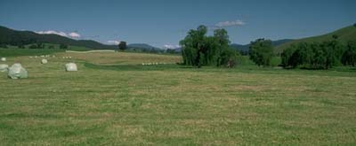 Site NE25 Landscape |
Soil Profile Morphology:
Surface Soil
| A1 | 0-15 cm | Very dark greyish brown (10YR3/2); fine sandy clay loam, moderate medium blocky parting to moderate fine blocky structure; firm consistence moist; pH 5.6; clear change to: | 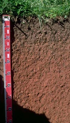 Site NE25 Profile |
| A2 | 15-30 cm | Strong brown (7.5YR4/6) with brown (7.5YR4/4) mixing due to worm activity; fine sandy clay loam; moderate coarse blocky, parting to moderate fine blocky structure; firm consistence moist; pH 5.7; clear change to: | |
| Subsoil | |||
| B21 | 30-50 cm | Yellowish red (5YR4/6); clay loam (fine sandy); moderate medium blocky, parting to strong fine blocky structure; firm consistence moist; pH 6.0; gradual change to: | |
| B22 | 50-70 cm | Yellowish red (5YR4/6); fine sandy light clay; moderate medium blocky, parting to strong fine blocky structure; firm consistence moist; pH 6.0; gradual change to: | |
| B23 | 70-85 cm | Yellowish red (5YR5/8); light clay; moderate medium blocky, parting to moderate fine blocky structure; firm consistence moist; pH 6.1; clear change to: | |
| B31 | 85+ cm | Strong brown (7.5YR5/6); light clay; moderate medium blocky, parting to moderate fine blocky structure; weak consistence moist; contains soft manganese segregations at 90 cm; pH 6.4. | |
| Note: At 150 cm depth a coarse river gravel layer is encountered. | |||
Key Profile Features:
- Gradual increase in clay content and pH with depth.
Horizon | pH | Salinity Rating | ||
Surface (A1 horizon) | moderately acid | very low | non-sodic | none |
Subsoil (B21 horizon) | moderately acid | very low | non-sodic | none |
Deeper Subsoil (at 90 cm) | slightly acid | very low | non-sodic | none |
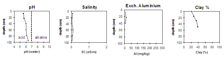
Horizon | Horizon Depth (cm) | pH (water) | pH (CaCl2) | EC 1:5 | Exchangeable Cations | |||
Ca | Mg | K | Na | |||||
meq/100g | ||||||||
A1 | 0-15 | 5.6 | 4.9 | 0.08 | 7.4 | 1.4 | 0.9 | <0.1 |
A2 | 15-30 | 5.7 | 4.8 | <0.05 | 3.6 | 0.8 | 0.8 | <0.1 |
B21 | 30-50 | 6.0 | 5.1 | <0.05 | 4.2 | 1.2 | 0.8 | <0.1 |
B22 | 50-70 | 6.0 | 5.3 | 0.09 | 4.5 | 1.6 | 1.0 | 0.1 |
B23 | 70-85 | 6.1 | 5.5 | 0.06 | 4.1 | 1.7 | 0.9 | <0.1 |
B31 | 85+ | 6.4 | 5.7 | <0.05 | 3.7 | 1.8 | 0.8 | <0.1 |
Horizon | Horizon Depth (cm) | Exchangeable Aluminium mg/kg | Field Capacity pF 2.5 | Wilting Point pF 4.2 | Coarse Sand (0.2-2.0 mm) | Fine Sand (0.02-0.2 mm) | Silt (0.002-0.02 mm) | Clay (<0.002 mm) |
A1 | 0-15 | <10 | 39 | 12 | 4 | 32 | 38 | 21 |
A2 | 15-30 | 13 | 31 | 10 | 3 | 33 | 41 | 27 |
B21 | 30-50 | <10 | 29 | 12 | 3 | 29 | 37 | 35 |
B22 | 50-70 | 30 | 14 | 2 | 27 | 36 | 39 | |
B23 | 70-85 | |||||||
B31 | 85+ |
Management Considerations:
Whole Profile
- Plant available water capacity (PAWC) is considered to be medium (estimated at approximately 120 mm). This is based on available laboratory data and assumes an effective rooting depth of 100 cm (depth to which plant roots were evident in the soil pit).
- The soil profile will be relatively well drained due to the gradual increase in clay with depth and reasonably well developed soil structure. The presence of coarse river gravels at 1.5 metres will ensure free drainage at depth.
- The surface soil has a high silt (38%) and fine sand (32%) content. Such soils are likely to slake upon rapid wetting if organic matter levels are low. This will result in surface sealing and exacerbate the hardsetting condition which will restrict seedling emergence and water infiltration. Organic matter levels are likely to decline if cultivation takes place.
- The surface horizons are moderately acid and exchangeable aluminium levels are low. Maintaining a surface soil pH above 5.5 should ensure that aluminium toxicity does not become a problem. However, the likelihood of aluminium toxicity is best assessed on a bulked sample taken from across the paddock.
- The upper subsoil horizons will provide a good plant rooting environment. They are reasonably well structured, non-sodic, have a relatively high calcium:magnesium ratio, are moderately acid and are also likely to be well drained.
- Annual subclover (~80%), annual ryegrass, barley grass.