Victorian Resources Online (archived)
NE26
| Location: Tallangatta Valley Landcare Group. | Australian Soil Classification: Bleached-Acidic, Mesotrophic, Red KUROSOL |
| Northcote Factual Key: Dr 2.41 | Great Soil Group: red podzolic. |
| General Landscape Description: Lower slope beneath rolling metamorphic hills. This site is most likely on an alluvial fan which has also been influenced by colluvium from higher areas. | |
| Native Vegetation: Original vegetation included Narrow-leaved peppermint (Eucalyptus radiata robertsonii), Broad-leaved peppermint (E. dives), Red stringybark (E. macrorhyncha). | |
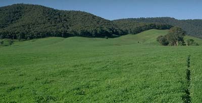 Site NE26 Landscape |
Soil Profile Morphology:
Surface Soil
| A1 | 0-10 cm | Dark brown (7.5YR3/2); fine sandy loam; weak coarse blocky structure; weak consistence moist; contains a few (2%) angular quartz gravels (4 mm diameter); pH 4.8; clear change to: | 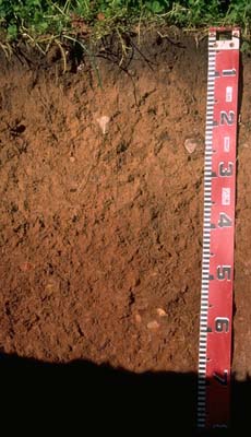 Site NE26 Profile |
| A2 | 10-40 cm | Strong brown (7.5YR5/6) conspicuously bleached (10YR7/4); fine sandy loam becoming light fine sandy clay loam with depth; weak consistence moist; contains a few (5%) angular quartz (5 mm diameter) and schist (60 mm diameter); pH 5.1; clear change to: | |
| Subsoil | |||
| B21 | 40-50 cm | Yellowish red (5YR5/8); fine sandy light clay; moderate medium blocky, parting to moderate fine blocky structure; firm consistence moist; pH 5.4; clear change to: | |
| B22 | 50-100 cm | Yellowish red (5YR5/6); fine sandy light clay; strong medium blocky, parting to moderate fine blocky structure; contains a few (5%) angular quartz and schist fragments (3-4 mm diameter); pH 5.5: | |
| B3 | 100-180 cm | Dark red (2.5YR4/8) with reddish yellow (7.5YR6/8) mottles; fine sandy clay loam; contains sandy pockets and mica; pH 5.3. | |
Key Profile Features:
- Texture contrast between surface (A) horizons and subsoil (B21) horizon.
- Strongly acid subsoil.
Soil Profile Characteristics:
Horizon | pH | Salinity Rating | ||
Surface (A1 horizon) | very strongly acid | very low | non-sodic | none |
Subsoil (B21 horizon) | strongly acid | very low | non-sodic | none |
Deeper Subsoil (at 1 m) | strongly acid | very low | non-sodic | none |
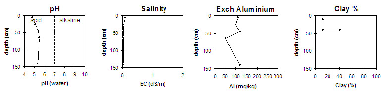
Horizon | Horizon Depth (cm) | pH (water) | pH (CaCl2) | EC 1:5 | Exchangeable Cations | |||
Ca | Mg | K | Na | |||||
meq/100g | ||||||||
A1 | 0-10 | 4.8 | 4.2 | 0.1 | 2.0 | 0.4 | 0.3 | <0.1 |
A2 | 10-40 | 5.1 | 4.4 | <0.05 | 0.3 | 0.1 | 0.2 | <0.1 |
B21 | 40-50 | 5.4 | 4.5 | <0.05 | 2.6 | 1.0 | 0.4 | <0.1 |
B22 | 50-80 | 5.5 | 4.8 | <0.05 | 3.1 | 3.6 | 0.5 | <0.1 |
B3 | 100-180 | 5.3 | 4.6 | <0.05 | 0.6 | 2.3 | 0.5 | <0.1 |
Horizon | Horizon Depth (cm) | Exchangeable Aluminium mg/kg | Field Capacity pF 2.5 | Wilting Point pF 4.2 | Coarse Sand (0.2-2.0 mm) | Fine Sand (0.02-0.2 mm) | Silt (0.002-0.02 mm) | Clay (<0.002 mm) |
A1 | 0-10 | 110 | 28 | 9 | ||||
A2 | 10-40 | 100 | 18 | 4 | 18 | 53 | 19 | 12 |
B21 | 40-50 | 120 | 26 | 14 | 10 | 35 | 15 | 41 |
B22 | 50-80 | 53 | 36 | 21 | ||||
B3 | 100-180 | 120 |
Management Considerations:
Whole Profile
- Plant available water capacity (PAWC) is considered to be medium (estimated at 110 mm). This is based on available laboratory data and assumes an effective rooting depth of 100 cm.
- The surface soil has a high fine sand content which indicates that significant slaking will occur if organic matter levels decline. Organic matter levels are reasonably high at this site.
- The surface soil is very strongly acid which indicates that aluminium and manganese toxicity may occur. The level of exchangeable aluminium (110 mg/kg) measured at this pit site is high enough to restrict the growth of aluminium sensitive species e.g. lucerne, phalaris, some medics. A pH/aluminium test on a bulked sample taken from across the paddock would be useful for determining the amount of lime needed to raise soil pH. Other factors that need to be considered before lime is recommended include: pasture species grown, method of application, local trial responses and likely cost/benefit.
- Deficiencies in molybdenum, phosphorous and potassium may occur in the very strongly acid surface soil. Lime application may assist in increasing phosphorous availability. Plant tissue analysis could provide a more accurate assessment of molybdenum requirements.
- The level of exchangeable aluminium (100 mg/kg) measured in the subsurface (A2) horizon is high similar to the surface (A1) horizon .
- The top of the subsoil is strongly acid and the level of exchangeable aluminium (120 mg/kg) is still likely to affect aluminium sensitive species. Surface liming will have a negligible impact on the pH in the subsoil due to the deepness of the subsoil.