Victorian Resources Online (archived)
NE29
| Location: Tallangatta Valley Landcare Group. | Australian Soil Classification: Acidic, Mesotrophic, Red DERMOSOL |
| Northcote Factual Key: Gn | Great Soil Group: red podzolic. |
| General Landscape Description: Road cutting in a lower-mid slope position on a rolling hill (Ordovician sediments). | |
| Native Vegetation: Original vegetation included Apple Box (Eucalyptus bridgesiana) and Broad-leaved Peppermint (E. dives). | |
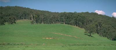 Site NE29 Landscape |
Soil Profile Morphology:
Surface Soil
| A1 | 0-5 cm | Dark brown (10YR3/3); light fine sandy clay loam; firm consistence moist; contains many (30%) angular gravels (6 mm average diameter); pH 5.4; abrupt change to: | 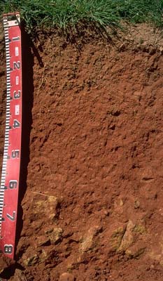 Site NE29 Profile |
| A2 | 5-20 cm | Yellowish red (5YR5/7); fine sandy clay loam; weak medium blocky structure; firm consistence moist; contains a common (15%) amount of gravel (5 mm average size); pH 5.3; clear change to: | |
| Subsoil | |||
| B21 | 20-35 cm | Dark red (2.5YR4.5/8); light clay (fine sandy); moderate medium blocky structure; firm consistence moderately moist; pH 5.3; gradual change to: | |
| B22 | 35-60 cm | Dark red (2.5YR4/8); light clay (fine sandy); weak medium blocky structure; weak consistence moist; pH 5.1; gradual change to: | |
| B/C | 60-90 cm | Weathered metamorphosed siltstone. | |
Key Profile Features:
- Shallow soil profile (i.e. 60 cm).
- Moderate texture contrast between surface (A) horizons and subsoil (B) horizons.
- Strongly acid throughout.
Soil Profile Characteristics:
Horizon | pH | Salinity Rating |
Surface (A1 horizon) | strongly acid | very low |
Subsoil (B21 horizon) | strongly acid | very low |
Deeper subsoil (at 45 cm) | strongly acid | very low |
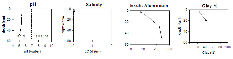
Horizon | Horizon Depth (cm) | pH (water) | pH (CaCl2) | EC 1:5 |
A1 | 0-5 | 5.4 | 4.6 | 0.07 |
A2 | 5-20 | 5.3 | 4.4 | <0.05 |
B21 | 20-35 | 5.3 | 4.4 | <0.05 |
B22 | 35-60 | 5.1 | 4.4 | <0.05 |
Horizon | Horizon Depth (cm) | Exchangeable Aluminium mg/kg | Field Capacity pF 2.5 | Wilting Point pF 4.2 | Coarse Sand (0.2-2.0 mm) | Fine Sand (0.02-0.2 mm) | Silt (0.002-0.02 mm) | Clay (<0.002 mm) |
A1 | 0-5 | 77 | 41 | 11 | ||||
A2 | 5-20 | 140 | 33 | 9 | 15 | 29 | 31 | 25 |
B21 | 20-35 | 220 | 28 | 13 | 12 | 25 | 22 | 43 |
B22 | 35-60 | 240 | 27 | 14 |
Management Considerations:
Whole Profile
- Plant available water capacity (PAWC) is considered to be low (estimated at 85 mm) for this site. This is based on available
- The surface (A1) horizon is strongly acid which indicates that aluminium and manganese toxicity may occur. The level of exchangeable aluminium in the A1 horizon as measured in the laboratory is 77 mg/kg and in the A2 horizon it is 140 mg/kg. This is high enough to affect the growth of highly aluminium sensitive species e.g. lucerne and phalaris. A pH/aluminium test on a bulked sample taken from across the paddock would be most appropriate for determining how much lime is needed to raise soil pH. However, other factors need to be considered before lime is recommended e.g. pasture species grown, method of application, local trial responses, likely cost/benefit.
- The surface soil has a high fine sand (29%) and silt (31%) content. As a result, structural degradation is likely to occur if organic matter levels become low. At low organic matter levels, slaking will be promoted which can result in surface sealing (reducing water infiltration) and increased hardsetting. Fortunately, organic matter levels are quite high at this site, as would be expected from permanent pasture. However, sheet erosion is likely if the surface soil is exposed.
- The subsoil is strongly acid and the level of exchangeable aluminium measured is high (240 mg/kg). Lime application to the surface soil will have a negligible effect on decreasing aluminium toxicity in the subsoil, due to the reliance on the lime being washed down the profile.
- The red colour of the subsoil indicates that it is well drained. Subsoil drainage will be promoted by the weathered and fractured fine grained bedrock.
- Superphosphate applied.