Victorian Resources Online (archived)
EGC205
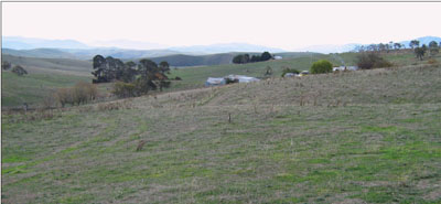
Location: Hinnomunjie
Australian Soil Classification: Eutrophic, Brown CHROMOSOL
Map Unit: Hinnomunjie (Component 2)
Previous Site Name: EG205
General Landscape Description: Rolling low hills
Site description: Lower north-west facing slope (8% slope)
Land Use: Grazing on annual pasture
Native Vegetation: Montane dry woodland
Geology: Ordovician metamorphosed sediments
Soil Profile Morphology:
| Surface soil | 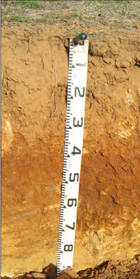 | ||
| A11 | 0 – 15 cm | Reddish brown (5YR4/3); clay loam; weak medium polyhedral structure; weak consistence dry; pH 5.2; clear change to: | |
| A12 | 15 – 25 cm | Reddish brown (5YR5/4); clay loam; weak medium (10 – 20 mm) polyhedral structure; weak consistence dry; many angular tabular pebbles; pH 5.2; clear change to: | |
| A13 | 25 – 30 cm | Red (2.5YR4/6); clay loam; strong fine granular structure; firm consistence dry; many angular tabular (20 – 60 mm) pebbles; pH 5.6; diffuse change to: | |
| Subsoil | |||
| B1 | 30 – 40 cm | Red (2.5YR4/6); light medium clay; strong fine granular structure; firm consistence dry; pH 6.0; clear change to: | |
| B21 | 40 – 65 cm | Reddish brown (7.5YR4/4); medium clay; strong fine granular structure; firm consistence dry; pH 6.0; clear change to: | |
| C | 65 – 85 cm | Brown (7.5YR4/4); medium clay with soft rock; common angular tabular (6 – 20 mm) pebbles; soft rock increasing with depth. |
Key Profile Features:
- Gradual increase in soil texture down the soil profile.
Soil Profile Characteristics:
- | pH | Salinity | ||
Surface soil (A1 horizon) | Strongly Acid | Very Low | Non-sodic | None |
Subsoil (B21 horizon) | Moderately Acid | Very Low | Non-sodic | None |
Deep subsoil (B22 horizon) | Slightly Acid | Very Low | Non-sodic | None |
Chemical and Physical Analysis:
Horizon | Horizon Depth (cm) | pH (water) | pH (CaCl2) | EC dS/m | Organic Carbon % | Total Nitrogen % | Free Fe2O3 % w/w | Exchangeable Aluminium ppm | Exchangeable Acididty meq/100g | Exchangeable Cations | Coarse Sand (0.2-2.0 mm) % | Fine Sand (0.02-0.2 mm) % | Silt (0.002-0.02 mm) % | Clay (<0.002 mm) % | Field Capacity % w/w | Wilting Point % w/w | |||
Ca | Mg | K | Na | ||||||||||||||||
meq/100g | |||||||||||||||||||
A11 | 0-15 | 5.2 | 4.7 | 0.13 | 2.5 | 0.19 | 3.4 | 12 | 5.7 | 3 | 1 | 0.5 | 0.07 | 16 | 51 | 10 | 16 | 19.7 | 6.1 |
A12 | 15-25 | 5.2 | 4.6 | 0.07 | 1.2 | 0.09 | 18 | 5.1 | 2.3 | 0.83 | 0.22 | 0.08 | 18 | 52 | 8 | 18 | 18.3 | 5.4 | |
A13 | 25-30 | 5.6 | 4.9 | <0.05 | 0.84 | 11 | 4.7 | 2.5 | 1.5 | 0.22 | 0.09 | 18 | 49 | 12 | 17 | 19.6 | 6.6 | ||
B21 | 30-40 | 6.0 | 5.2 | <0.05 | 0.68 | <10 | 6.2 | 3.3 | 3.8 | 0.25 | 0.16 | 7 | 46 | 13 | 31 | 24.5 | 11.4 | ||
B22 | 40-65 | 6.5 | 5.6 | <0.05 | 0.7 | 11.0 | 5.3 | 9 | 0.37 | 0.28 | 2 | 16 | 9 | 70 | 37.9 | 24.7 | |||
Management Considerations
Whole profile
- Infiltration of water though the upper part of the soil profile will be rapid due to porous nature of the surface horizons.
- Plant available water content for this profile is considered to be moderate, based on a plant root depth of 65 cm.
- The clay content increases quite markedly at 40 cm.
- The low wilting point (6.1, 5.4 and 6.6) of the surface soils indicates the plants are able to utilise very light rains when the soil is dry. However, due to the low water storage capacity, plants will soon suffer moisture stress unless further rains occur.
- The organic matter content of the soil is high. Such levels result in a good structural condition and good structural stability.
- The surface soil is strongly acid and a pasture response to lime additions would be quite likely. As the soil is also fairly high in iron oxide, deficiencies in phosphorus and molybdenum are likely and lime applications would increase nutrient availability.
- Potassium at a moderate level for pastures and no response to potassium fertiliser would be expected.
- Salinity is not a problem in the surface soil.
- The nutrient holding capacity of the surface horizons is low (based on the sum of the exchangeable calcium, magnesium, potassium and sodium cations). Organic matter is important for maintaining soil fertility on such soils.
- The subsoil and the deep subsoil are not sodic and do not disperse. However both slake considerably and if the subsoil is exposed, for example by a gully head, headward erosion is very highly likely.
Profile Described By: Heather Adams, Julieanne Sargant and Ian Sargeant, June 2009.