Victorian Resources Online (archived)
EGC211
Location: Benambra (East of township)
Australian Soil Classification: Eutrophic, Subnatric, Black SODOSOL
Map Unit: Benambra (Component 1)
Previous Site Name: EG211
General Landscape Description: Almost level plain
Land Use: Lucerne
Native Vegetation: Montane grassland
Geology: Pleistocene to recent alluvial deposits
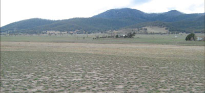
Photo taken from pit looking towards the north-east. The narrow present flood plain of
Morass Creek is in the middle ground
Soil Profile Morphology:
| Surface soil | 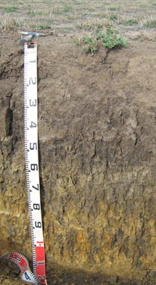 | ||
| A1 | 0 – 25 cm | Very dark greyish brown (10YR3/2); clay loam; strong medium (10 -20 mm) granular structure; weak consistence dry; pH 5.0; abrupt change to: | |
| Subsoil | |||
| B21 | 25 – 55 cm | Very dark greyish brown (10YR3/2); medium clay; coarse (20 – 50 mm) strong columnar structure; strong consistence dry; pH 6.5; diffuse change to: | |
| B22 | 55 – 90 cm | Very dark greyish brown (10YR3/2) mottled with yellowish brown (10YR5/4); medium clay; coarse (20 – 50 mm) moderate prismatic structure; strong consistence dry; pH 7.8; diffuse change to: | |
| B23 | 90 – 115 cm | Greyish brown (10YR5/2) and yellowish brown (10YR5/6) with distinct very dark greyish brown (10YR3/2) mottles; medium clay; moderate coarse (20 – 50 mm) prismatic structure; very firm consistence dry; pH 8.2. |
Key Profile Features:
- Texture contrast between the surface (A1) horizon and subsoil (B21) horizon
Soil Profile Characteristics:
- | pH | Salinity | ||
Surface soil (A1 horizon) | Strongly Acid | Low | Non-sodic | None |
Subsoil (B21 horizon) | Slightly Alkaline | Very low | Sodic | None1 |
Deeper subsoil 90-115 cm | Moderately Alkaline | Low | Strongly Aodic | Slight1 |
Chemical and Physical Analysis:
Horizon | Horizon Depth (cm) | pH (water) | EC dS/m | Organic Carbon % | Total Nitrogen % | Exchangeable Aluminium ppm | Exchangeable Acididty meq/100g | Exchangeable Cations | Coarse Sand (0.2-2.0 mm) % | Fine Sand (0.02-0.2 mm) % | Silt (0.002-0.02 mm) % | Clay (<0.002 mm) % | Field Capacity % w/w | Wilting Point % w/w | |||
Ca | Mg | K | Na | ||||||||||||||
meq/100g | |||||||||||||||||
A1 | 0-25 | 5.0 | 0.17 | 4.0 | 0.32 | 17 | 11.0 | 7.0 | 3.7 | 0.52 | 0.24 | 9 | 33 | 24 | 23 | 35.9 | 12.9 |
B21 | 25-55 | 6.5 | 0.06 | 1.1 | 0.08 | 7.4 | 6.0 | 6.9 | 0.2 | 1.3 | 11 | 29 | 19 | 36 | 30.9 | 15.9 | |
B22 | 55-90 | 7.8 | 0.09 | 0.66 | 6.2 | 7.3 | 0.25 | 2.2 | 3 | 27 | 23 | 41 | 38.9 | 18.9 | |||
B23 | 90-115 | 8.2 | 0.16 | 0.39 | 6.1 | 6.4 | 0.16 | 3.3 | 12 | 36 | 17 | 34 | 33.4 | 16.2 | |||
Management Considerations
Whole profile
- Plant available water is considered to be moderate, based on an effective rooting depth of 55 cm.
- The surface soil is strongly acid. However the level of exchangeable aluminium is low (17 mg/kg) and is unlikely to affect the growth of aluminium sensitive species, particularly as the soil becomes alkaline with depth. Lime can be used to increase soil pH but a pH/aluminium test is best performed by taking samples across the paddock and bulked together. The use of test strips to observe lime response could be used as an aid in evaluating its cost/benefit. At a pH of 5.0, a pH response would be expected.
- Potassium levels in the surface soil are moderate and plant responses to potassium fertiliser is unlikely.
- Salinity is not a problem in the surface soil.
- Deficiencies of molybdenum and phosphorus may occur in the strongly acid surface soils and increasing the pH by lime application should enable the phosphorus (from superphosphate) and molybdenum to become more available.
- The nutrient holding capacity of the surface (A1) horizon is moderate (based on the sum of the exchangeable calcium, magnesium, potassium and sodium cations).
- The pH increases with depth, thus allowing the successful growing of deep rooting aluminium sensitive species (e.g. lucerne).
- The coarse strong prismatic nature of the clay B horizon confines the roots to cracks and makes it difficult for the roots to fully exploit the soil. As the subsoil is sodic and the deep subsoil strongly sodic, root and downward water movement may be restricted.
Soil Profile Described By: Heather Adams, Julieanne Sargant and Ian Sargeant, June 2009.