Victorian Resources Online (archived)
EGC212
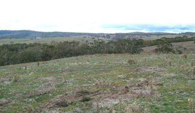
Location: Benambra
Australian Soil Classification: Bleached, Eutrophic, Red KANDOSOL
Map Unit: Cobungra (Component 1)
Previous Site Name: EG212
General Landscape Description: Rounded low hills
Site Description: Upper north facing slope (5% slope)
Land Use: Grazing on annual pasture
Native Vegetation: Montane grassy woodland and herb rich woodland
Geology: Palaeozoic granite
Soil Profile Morphology:
| Surface soil | 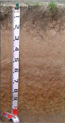 | ||
| A1 | 0 – 15 cm | Dark brown (10YR4/3); coarsesandy loam; weak medium (10 – 20 mm) granular structure; very weak consistence dry; pH 5.1; clear change to: | |
| A21 | 15 – 35 cm | Light brown (7.5YR6/4), conspicuously beached (7.5YR7/2d); coarse sandy loam; apedal; very weak consistence dry; pH 5.3; diffuse change to: | |
| A22 | 35 – 60 cm | Brown (7.5YR5/4); coarse sandy loam; apedal; weak consistence dry; pH 6.2; clear change to: | |
| Subsoil | |||
| B21 | 60 – 100 cm | Yellowish red (5YR5/6); sandy clay loam; apedal; firm consistence dry; pH 6.6; diffuse change to: | |
| B22 | 100 – 110 cm | Yellowish red (5YR5/6) with white flecks of feldspar; clayey sand; apedal; firm consistence dry |
Key Profile Features:
- Lack of a marked texture contrast between the surface (A) horizon and the subsoil (B) horizon.
- The sandy and hard setting nature of the soil profile.
Soil Profile Characteristics:
- | pH | Salinity | ||
Surface soil (A1 horizon) | Strongly Acid | Very Low | Non-sodic | None |
Subsurface soil (A21 horizon) | Strongly Acid | Very Low | Non-sodic | Slight |
Deeper subsoil (B21 horizon) | Slightly Acid | Very Low | Non-sodic | None |
Chemical and Physical Analysis:
Horizon | Horizon Depth (cm) | pH (water) | EC dS/m | Organic Carbon % | Total Nitrogen % | Exchangeable Aluminium ppm | Exchangeable Acididty meq/100g | Exchangeable Cations | Coarse Sand (0.2-2.0 mm) % | Fine Sand (0.02-0.2 mm) % | Silt (0.002-0.02 mm) % | Clay (<0.002 mm) % | Field Capacity % w/w | Wilting Point % w/w | |||
Ca | Mg | K | Na | ||||||||||||||
meq/100g | |||||||||||||||||
A1 | 0-15 | 5.1 | 0.08 | 2.2 | 0.12 | 20 | 7.2 | 2.5 | 0.4 | 0.4 | <0.05 | 40 | 34 | 12 | 8 | 23.1 | 4.9 |
A21 | 15-35 | 5.3 | <0.05 | 0.56 | <0.05 | 19 | 2.1 | 0.84 | 0.13 | 0.16 | <0.05 | 37 | 36 | 11 | 13 | 16.6 | 2.3 |
A22 | 35-60 | 6.2 | <0.05 | 0.39 | 1.3 | 1.2 | 0.19 | 0.11 | <0.05 | 43 | 31 | 12 | 13 | 14.2 | 2.5 | ||
B21 | 60-110 | 6.6 | <0.05 | 0.3 | 1.2 | 4 | 1.7 | 0.27 | 0.07 | 39 | 26 | 11 | 20 | 29.0 | 9.7 | ||
Management Considerations
Whole profile
- Plant available water is considered to be very low. Effective rooting depth is largely confined to the surface 25 cm because of the dense and hard-setting nature of the soil below this layer.
- The deep subsoil slakes considerably when wet and, as a result, would be prone to tunnel and gully erosion in the wetter parts of the landscape.
- The soil has good external and internal drainage and is not likely to become waterlogged during wetter periods.
- The surface soil is strongly acid. However the level of exchangeable aluminium is reasonably low (20 mg/kg) and is unlikely to affect the growth of aluminium sensitive species, except the most sensitive. Lime can be used to increase soil pH but a pH/aluminium test is best performed by taking samples across the paddock and bulked together. The use of test strips to observe lime response could be used as an aid in evaluating its cost/benefit. For this soil a response to lime (about 1-2 tonnes/ha) would be expected.
- Potassium levels are moderate and plant responses to potassium fertiliser are unlikely given the present grazing management practices.
- Salinity is not a problem in the surface soil.
- Deficiencies of molybdenum and phosphorus may occur in the strongly acid surface soils and increasing the pH by lime application should enable the phosphorus (from superphosphate) and molybdenum to become more available.
- The nutrient holding capacity of the surface (A1 and A21) horizons is very low (based on the sum of the exchangeable calcium, magnesium, potassium and sodium cations).
- Root growth would be severely restricted because of the dense and hard nature.
- The deep subsoil slakes considerably when wet, making it prone to tunnel and gully erosion.
Soil Profile Described By: Heather Adams, Julieanne Sargant and Ian Sargeant, June 2009.